Search Results
Howard Hughes standing in the doorway of his plane at the Grand Central Air Terminal in Los Angeles, 1938
Level of Description
File
Archival Collection
Howard Hughes Public Relations Photograph Collection
To request this item in person:
Collection Number: PH-00373
Collection Name: Howard Hughes Public Relations Photograph Collection
Box/Folder: Folder 15
Collection Name: Howard Hughes Public Relations Photograph Collection
Box/Folder: Folder 15
Archival Component
View of Waldorf Astoria, St. Bartholomew's Church, and Pan Am building from Park Avenue, New York City, New York: panoramic photograph, 1981 May 24
Level of Description
Item
Archival Collection
Bob Paluzzi Panoramic Photographs
To request this item in person:
Collection Number: PH-00414
Collection Name: Bob Paluzzi Panoramic Photographs
Box/Folder: Box 07, Digital File 00
Collection Name: Bob Paluzzi Panoramic Photographs
Box/Folder: Box 07, Digital File 00
Archival Component

Map of California and territories of New Mexico and Utah, circa 1861
Date
1856 to 1866
Description
40 x 60 cm. Relief shown by hachures and spot heights. Prime meridians: Greenwich and Washington. Atlas plate numbers 54 and 55 in the upper corners. Shows forts, trails, exploration routes, drainage, mail steamship routes, physical features, Indian tribes, and historic sites. The geographic region of Southwest is referred to as the New Southwest. Original publisher: Johnson .
Image
T-Shirt Color: Navy Blue; Front: In Memory Of Our Fallen Heroes 9-11-01, Twin Towers; Back: Freedom Is Never Free Port Authority Police New York New Jersey 37, Fire Department City Of New York 34, Police Department City Of New York 23, Dept. Emblems, approximately 2001-2012
Level of Description
File
Archival Collection
New York-New York Hotel and Casino 9-11 Heroes Tribute Collection
To request this item in person:
Collection Number: MS-00459
Collection Name: New York-New York Hotel and Casino 9-11 Heroes Tribute Collection
Box/Folder: Box 234
Collection Name: New York-New York Hotel and Casino 9-11 Heroes Tribute Collection
Box/Folder: Box 234
Archival Component
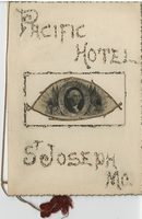
New York's Day Banquet, Saturday, February 22, 1890, menu, Pacific Hotel
Date
1890-02-22
Archival Collection
Description
Note: New York's Day Banquet, Saturday, February 22, '90--p. 2. Cover has oval portrait of George Washington surrounded by American flags, a drum, a sickle and a compass, set in an eye-shaped, raised frame. Lettering on the cover is raised and pasted with glitter. Menu bound with red cord; scalloped edges Restaurant: Pacific Hotel Location: St. Joseph, Missouri, United States
Text
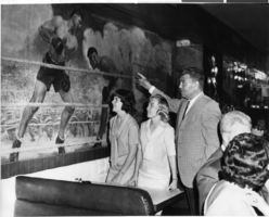
Photograph of two Las Vegas High School Rhythmettes and Jack Dempsey, New York City, June 1964
Date
1964-06
Archival Collection
Description
Two of the Las Vegas High School Rhythmettes with Jack Dempsey in his restaurant in New York City, New York.
Image

Map of California, Utah, Nevada, Colorado, New Mexico and Arizona, 1864
Date
1864
Description
'Johnson's California, with Utah, Nevada, Colorado, New Mexico, and Arizona, published by Johnson and Ward.' 'Entered according to Act of Congress in the Year 1864 by A.J. Johnson in the Clerks Office of the District Court of the United States for the southern district of New York.' Atlas page numbers in upper margin: 66-67. This is probably plate 67 from Johnson's New Illustrated Family Atlas, published in New York by Johnson & Ward in 1864. Shows natural features, locations of Indian tribes, proposed railroad routes, routes of explorers, trails, county boundaries and populated places ; "." ; Relief shown by hachures ; Prime meridians: Greenwich and Washington ; In top margin: 66-67 ; Hand colored ; On verso: Historical and statistical view of Mexico and central America (p. 79) and Historical and statistical view of the United States, 1860 (p. 78) Scale [ca. 1:3,484,800]. 1 in. to ca. 55 miles (W 124°--W 102°/N 42°--N 32°)
Text
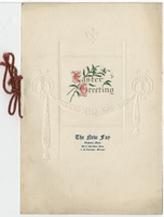
The New Fay Easter dinner menu, Sunday, April 7, 1912
Date
1912-04-07
Archival Collection
Description
Restaurant: The New Fay (Virginia, Minn.) Location: Virginia, Minnesota, United States
Text
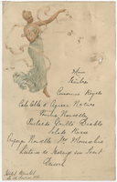
Hôtel Bristol menu, February 15, 1890
Date
1890-02-15
Archival Collection
Description
Note: Handwritten menu Restaurant: Hôtel Bristol
Text
Lottery ticket from Honduras National Lottery Company in Louisiana; lottery ticket-beneficencia; New York state lottery advertisement; New York state Olympic lottery, 1904-1979
Level of Description
File
Archival Collection
UNLV University Libraries Collection on International Lotteries
To request this item in person:
Collection Number: MS-00619
Collection Name: UNLV University Libraries Collection on International Lotteries
Box/Folder: Oversized Box 01
Collection Name: UNLV University Libraries Collection on International Lotteries
Box/Folder: Oversized Box 01
Archival Component