Search Results
Howard Hughes in the Lockheed 14, Los Angeles, California, 1938 July 04
Level of Description
File
Archival Collection
Howard Hughes Public Relations Photograph Collection
To request this item in person:
Collection Number: PH-00373
Collection Name: Howard Hughes Public Relations Photograph Collection
Box/Folder: Folder 05
Collection Name: Howard Hughes Public Relations Photograph Collection
Box/Folder: Folder 05
Archival Component
#57839: Nusbaum, Julie - Alumni, 1989 April 15
Level of Description
File
Archival Collection
University of Nevada, Las Vegas Creative Services Records (1980s)
To request this item in person:
Collection Number: PH-00388-02
Collection Name: University of Nevada, Las Vegas Creative Services Records (1980s)
Box/Folder: N/A
Collection Name: University of Nevada, Las Vegas Creative Services Records (1980s)
Box/Folder: N/A
Archival Component
Hotel Europa, Cartina, menu, 1969 July 15
Level of Description
File
Archival Collection
UNLV University Libraries Menu Collection
To request this item in person:
Collection Number: MS-00436
Collection Name: UNLV University Libraries Menu Collection
Box/Folder: Box 157
Collection Name: UNLV University Libraries Menu Collection
Box/Folder: Box 157
Archival Component
The Daily Telegraph, 1940 July 15
Level of Description
Item
Archival Collection
Mavis Eggle "Books as They Were Bought" Collection
To request this item in person:
Collection Number: MS-01144
Collection Name: Mavis Eggle "Books as They Were Bought" Collection
Box/Folder: Oversized Box 42
Collection Name: Mavis Eggle "Books as They Were Bought" Collection
Box/Folder: Oversized Box 42
Archival Component
Howard Hughes and Edward Lund at the Newark, New Jersey airport, 1937 January 19
Level of Description
File
Archival Collection
Howard Hughes Public Relations Photograph Collection
To request this item in person:
Collection Number: PH-00373
Collection Name: Howard Hughes Public Relations Photograph Collection
Box/Folder: Folder 02
Collection Name: Howard Hughes Public Relations Photograph Collection
Box/Folder: Folder 02
Archival Component
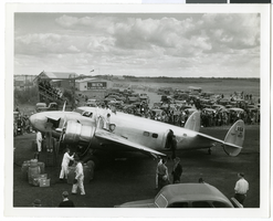
Photograph of the Lockheed 14 aircraft, Fairbanks, Alaska, July 15, 1938
Date
1938-07-15
Archival Collection
Description
The black and white view of several unidentified people and mechanics surrounding the Lockheed 14 aircraft for Howard Hughes' Around the World flight. Description printed on photograph's accompanying sheet of paper: "Ground crew refueling Lockheed 14. Crowd and hangar in background."
Image
Galt House, luncheon menu, 1883 July 15
Level of Description
Item
Archival Collection
Bohn-Bettoni Menu Collection
To request this item in person:
Collection Number: MS-00793
Collection Name: Bohn-Bettoni Menu Collection
Box/Folder: Box 06
Collection Name: Bohn-Bettoni Menu Collection
Box/Folder: Box 06
Archival Component
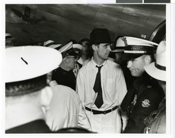
Photograph of Howard Hughes next to an airplane and surrounded by crowds at Houston Airport, Texas, July, 30, 1938
Date
1938-07-30
Archival Collection
Description
Howard Hughes (in hat) surrounded by crowd at Houston Airport, Houston, Texas.
Image
Raymond A. Cook, Mortimer Caplin, R. J. Cordiner, and Howard Hughes letters arguing against a claim deeming HHMI's assets as excessive, 1954 July 15 to 1956 March 26
Level of Description
File
Archival Collection
Howard Hughes Film Production Records
To request this item in person:
Collection Number: MS-01036
Collection Name: Howard Hughes Film Production Records
Box/Folder: Box 551 (Restrictions apply)
Collection Name: Howard Hughes Film Production Records
Box/Folder: Box 551 (Restrictions apply)
Archival Component
#04975: Cannon, Howard - signing over papers, 1983 April 15
Level of Description
File
Archival Collection
University of Nevada, Las Vegas Creative Services Records (1980s)
To request this item in person:
Collection Number: PH-00388-02
Collection Name: University of Nevada, Las Vegas Creative Services Records (1980s)
Box/Folder: N/A
Collection Name: University of Nevada, Las Vegas Creative Services Records (1980s)
Box/Folder: N/A
Archival Component