Search Results

Map of the territories of New Mexico, Arizona, Colorado, Nevada, and Utah, 1855
Date
1855
Description
29 x 36 cm. Relief shown by hachures. Prime meridians: Greenwich and Washington. "Entered according to act of Congress in the year 1855 by J.H. Colton & Co. in the Clerk's Office of the Dist. Office of the U.S. for the Southern. Dist. of New York." Hand colored. Decorative border. Atlas p. number in lower-right margin: 67. Shows routes of explorers, proposed railroad routes, wagon route, mail route, Indian reserves and mines. On verso: History and statistical view of Mexico. Original publisher: J.H. Colton.
Image
Howard Hughes sitting in the Northrop Gamma Racer in New York after setting new Miami-New York speed record, 1936 April 21
Level of Description
File
Archival Collection
Howard Hughes Public Relations Photograph Collection
To request this item in person:
Collection Number: PH-00373
Collection Name: Howard Hughes Public Relations Photograph Collection
Box/Folder: Folder 01
Collection Name: Howard Hughes Public Relations Photograph Collection
Box/Folder: Folder 01
Archival Component
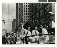
Photograph of Howard Hughes waving to crowds in a parade, Houston, Texas, July 30, 1938
Date
1938-07-30
Archival Collection
Description
Howard Hughes waving to crowds in a parade in Houston, Texas in 1938.
Image
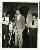
Photograph of Howard Hughes at a press conference beside his Douglas DC-3, New York, April, 1947
Date
1947-04
Archival Collection
Description
Howard Hughes giving a news Conference beside his airplane after landing in New York. This was his first flight after the nearly fatal XF-11 prototype crash in 1946.
Image
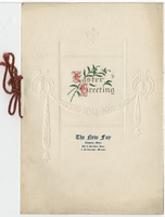
The New Fay Easter dinner menu, Sunday, April 7, 1912
Date
1912-04-07
Archival Collection
Description
Restaurant: The New Fay (Virginia, Minn.) Location: Virginia, Minnesota, United States
Text
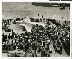
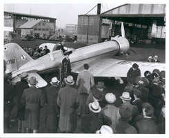
Photograph of crowds at Floyd Bennett Airfield, New York, July 14, 1938
Date
1938-07-14
Archival Collection
Description
The black and white view of Howard Hughes' Lockheed 14 aircraft after performing its final landing on the Round the World flight at Floyd Bennett Airport, New York. Description printed on photograph's accompanying sheet of paper: "Journey's end for world fliers! Floyd Bennett Airport, N.Y.--- The plane which carried Howard Hughes and four companions on their dramatic dash around the world, is shown shortly after it landed here at the conclusion of the flight. Crowds swarmed about the craft as the fliers hesitantly prepared to leave the ship. 7/14/1938."
Image
Photograph of Howard Hughes with Lockheed-14 plane, Le Bourget, France, July 11, 1938
Date
1938-07-11
Archival Collection
Description
Howard Hughes surrounded by a crowd at Le Bourget Field in France, in front of a Lockheed-14, July 11, 1938. Le Bourget (Airport : Le Bourget, France)
Image
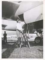
Photograph of Howard Hughes climbing into the XF-11, Culver City, California, July 7, 1946
Date
1946-07-07
Archival Collection
Description
Howard Hughes on a ladder, climbing into the XF-11. A police officer is seen in the background.
Image
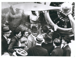
Photograph of Howard Hughes leaving the Northrop Gamma Racer, Newark, New Jersey, January 13, 1936
Date
1936-01-13
Archival Collection
Description
Howard Hughes leaving the cockpit of a Northrop Gamma, surrounded by a crowd at Newark New Jersey Airport. Hughes set a coast-to-coast speed record. A bank of microphones and a movie camera are seen beside the plane.
Image

Map of California, Utah, Nevada, Colorado, New Mexico and Arizona, 1864
Date
1864
Description
'Johnson's California, also Utah, Nevada, Colorado, New Mexico, and Arizona, published by A.J. Johnson, New York.' 'Entered according to Act of Congress in the Year 1864, by A.J. Johnson in the Clerks Office of the District Court of the United States for the Southern District of New York.' Atlas page numbers in upper margin: 66-67. Relief shown by hachures. Prime meridians: Greenwich and Washington, D.C. Shows proposed railroads, locations of Indian tribes, natural features, counties, mines, mail routes, trails and routes of exploring expeditions. On verso: History and statistics of Mexico and Central America and statistics of national finances and the Post Office of the United States, 1860. Scale [ca. 1:3,484,800. 1 in. to ca. 55 miles] (W 123°--W 103°/N 42°--N 32°)
Text