Search Results
Edward P. Mulrooney, City of New York, New York Police Commissioner, foreword on gun control, approximately 1930 to 1931
Level of Description
File
Archival Collection
Howard Hughes Film Production Records
To request this item in person:
Collection Number: MS-01036
Collection Name: Howard Hughes Film Production Records
Box/Folder: Box 056 (Restrictions apply)
Collection Name: Howard Hughes Film Production Records
Box/Folder: Box 056 (Restrictions apply)
Archival Component
Wilbur and Toni Clark at a formal dinner at the Hotel Astor in New York City, New York, 1958
Level of Description
File
Archival Collection
Toni and Wilbur Clark Photographs
To request this item in person:
Collection Number: PH-00302
Collection Name: Toni and Wilbur Clark Photographs
Box/Folder: Folder 10
Collection Name: Toni and Wilbur Clark Photographs
Box/Folder: Folder 10
Archival Component

Map of California, Utah, Nevada, Colorado, New Mexico and Arizona, circa 1867
Date
1865 to 1869
Description
39 x 56 cm. Relief shown by hachures. "Entered according to act of Congress in the year 1864, by A.J. Johnson in the Clerks Office of the United States for the Southern District of New York." Atlas page numbers in upper margin: 67-68. Primer meridians: Greenwich and Washington, D.C. On verso: History and statistical view of the West India islands or Columbian Archipelago and Historical and statistical view of Mexico and Central America. Shows proposed railroads, locations of Indian tribes, natural features, counties, mines, mail routes, trails and routes of exploring expeditions. Has decorative border. Southern part of Nevada was added to the state in 1867 and is part of Nevada on this map, but Lincoln County was established in 1867 and is not on this map. This map was still probably published in 1867 in spite of someone's having written "1864" in pencil in the lower right corner of the Library's copy. Original publisher: A.J. Johnson.
Image
#69800: UNLV Libraries employees pose for portraits July 15, 2014 at the University of Nevada, Las Vegas, 2014 July 15
Level of Description
File
Archival Collection
University of Nevada, Las Vegas Creative Services Records (2010s)
To request this item in person:
Collection Number: PH-00388-05
Collection Name: University of Nevada, Las Vegas Creative Services Records (2010s)
Box/Folder: Digital File 00
Collection Name: University of Nevada, Las Vegas Creative Services Records (2010s)
Box/Folder: Digital File 00
Archival Component
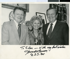
Photograph of Assemblywoman Eileen Brookman, Senator Howard Cannon and D.C. McSweeny, Nevada, March 15, 1978
Date
1978-03-15
Archival Collection
Description
The photograph depicts D.C. McSweeney, Nevada Assemblywoman Eileen Brookman and Nevada Senator Howard Cannon on the right. The photo was taken on March 15, 1978; location is unspecified. The picture is autographed to Eileen by Cannon. The inscriptions says: "To Eileen - with very best wishes. Howard Cannon, U.S.S. Nev."
Image
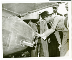
Photograph of Howard Hughes behind his plane at Le Bourget Airfield, France, July 1938
Date
1938-07
Archival Collection
Description
Description printed on accompanying strip of paper: "Howard Hughes inspects his machine on arrival at Le Bourget, France, on his round-the-world flight."
Image

City of Las Vegas map, 1952
Date
1952
Description
General information on Las Vegas and index on verso ; Copyright held by Redwood Publishing Co. ; Includes inset map of the Strip (U.S. 91 or Los Angeles Highway) ; Redwood Publishing Company
Text
Del Webb's Sahara Boardwalk-Atlantic City, New Jersey
Level of Description
File
Archival Collection
Martin Stern Architectural Records
To request this item in person:
Collection Number: MS-00382
Collection Name: Martin Stern Architectural Records
Box/Folder: N/A
Collection Name: Martin Stern Architectural Records
Box/Folder: N/A
Archival Component
Harrah's Marina Hotel Casino: Atlantic City, New Jersey
Level of Description
Series
Archival Collection
Martin Stern Architectural Records
To request this item in person:
Collection Number: MS-00382
Collection Name: Martin Stern Architectural Records
Box/Folder: N/A
Collection Name: Martin Stern Architectural Records
Box/Folder: N/A
Archival Component
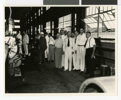
Photograph of Howard Hughes and men at Hughes Tool Company, Houston, Texas, July 30, 1938
Date
1938-07-30
Archival Collection
Description
Howard Hughes (2nd from right) with group of men inside the Hughes Tool Company shop in Houston.
Image