Search the Special Collections and Archives Portal
Search Results
New York Mine, Silver City, Nevada
Level of Description
File
Archival Collection
Mary Griffith Toleno Photograph Collection
To request this item in person:
Collection Number: PH-00021
Collection Name: Mary Griffith Toleno Photograph Collection
Box/Folder: N/A
Collection Name: Mary Griffith Toleno Photograph Collection
Box/Folder: N/A
Archival Component

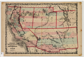
Map of California and territories of New Mexico and Utah, circa 1861
Date
1859 to 1862
Description
'Compiled, drawn, and engraved under the supervision of J.H. Colton and A.J. Johnson.' Relief shown by hachures and spot heights. Scale [ca. 1:3,041,280]. 1 in. to approx. 48 miles (W 124°--W 103°/N 42°--N 31°). Hand colored
Prime meridians: Greenwich and Washington
Plates 54 & 55 removed from Johnson's New illustrated family atlas of the world, with descriptions geographical, statistical and historical ... New York, 1862
Title page of atlas.
Prime meridians: Greenwich and Washington
Plates 54 & 55 removed from Johnson's New illustrated family atlas of the world, with descriptions geographical, statistical and historical ... New York, 1862
Title page of atlas.
Image

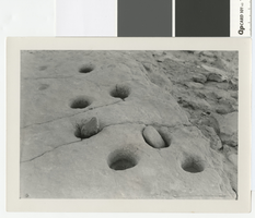
Photograph of a grinding slab metate at the Lost City, Clark County, before 1938
Date
1930 to 1938
Archival Collection
Description
Grinding slab metate at the Lost City with numerous holes
Transcribed Notes: Notes on photo sleeve Los City, Nevada. Holes and stones were used to grind grains, etc. (Credit: W.A. Davis); 'Gypsum Cave, bedrock mortars near cave' - W.A. Davis
Image
New Jersey: Atlantic City, 1989 to 1995
Level of Description
File
Archival Collection
UNLV Libraries Collection of Regional History Files
To request this item in person:
Collection Number: MS-00547
Collection Name: UNLV Libraries Collection of Regional History Files
Box/Folder: Box 27
Collection Name: UNLV Libraries Collection of Regional History Files
Box/Folder: Box 27
Archival Component
WFAN New York City radio, 1995
Level of Description
File
Archival Collection
Arnie and Sheila Wexler Professional Papers
To request this item in person:
Collection Number: MS-00579
Collection Name: Arnie and Sheila Wexler Professional Papers
Box/Folder: Box 01
Collection Name: Arnie and Sheila Wexler Professional Papers
Box/Folder: Box 01
Archival Component
WRFM New York City radio, 1976
Level of Description
File
Archival Collection
Arnie and Sheila Wexler Professional Papers
To request this item in person:
Collection Number: MS-00579
Collection Name: Arnie and Sheila Wexler Professional Papers
Box/Folder: Box 01
Collection Name: Arnie and Sheila Wexler Professional Papers
Box/Folder: Box 01
Archival Component

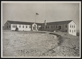
Photograph of a museum building, Boulder City (Nev.), January 10, 1938
Date
1938-01-10
Archival Collection
Description
Museum and Administration Building stands in a vacant dirt field. An American flag waves in front of the structure.
Image

Photograph of Anna Bailey at the Paramount Theatre, New York City
Date
Unknown year
Archival Collection
Description
Black and white photograph of Anna Bailey dancing onstage in front of a piano player at the Paramount Theatre in New York City.
Image
Howard Hughes and employees visiting Hughes Tool Company in Houston, Texas, 1938 July 30
Level of Description
File
Archival Collection
Howard Hughes Professional and Aeronautical Photographs
To request this item in person:
Collection Number: PH-00321
Collection Name: Howard Hughes Professional and Aeronautical Photographs
Box/Folder: Folder 08
Collection Name: Howard Hughes Professional and Aeronautical Photographs
Box/Folder: Folder 08
Archival Component
Howard Hughes with two others inside the Hughes Tool Company factory, 1938 July 30
Level of Description
File
Archival Collection
Howard Hughes Professional and Aeronautical Photographs
To request this item in person:
Collection Number: PH-00321
Collection Name: Howard Hughes Professional and Aeronautical Photographs
Box/Folder: Folder 05
Collection Name: Howard Hughes Professional and Aeronautical Photographs
Box/Folder: Folder 05
Archival Component
Pagination
Refine my results
Content Type
Creator or Contributor
Subject
Archival Collection
Digital Project
Resource Type
Year
Material Type
Place
Language
Records Classification
