Search Results
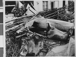
Photograph of crash of Howard Hughes' XF-11, Culver City, California, July 07, 1946
Date
1946-07-07
Archival Collection
Description
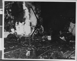
A view of the near-fatal crash of Howard Hughes' XF-11 in Culver City, California.
Image
Photograph of crash of Howard Hughes' XF-11, Culver City, California, July 07, 1946
Date
1946-07-07
Archival Collection
Description
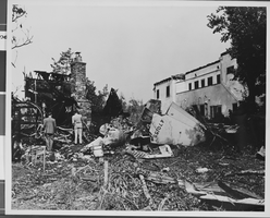
A view of the near-fatal crash of Howard Hughes' XF-11 in Culver City, California.
Image
Photograph of crash of Howard Hughes' XF-11, Culver City, California, July 07, 1946
Date
1946-07-07
Archival Collection
Description
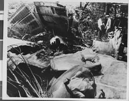
A view of the near-fatal crash of Howard Hughes' XF-11 in Culver City, California.
Image
Photograph of crash of Howard Hughes' XF-11, Culver City, California, July 07, 1946
Date
1946-07-07
Archival Collection
Description
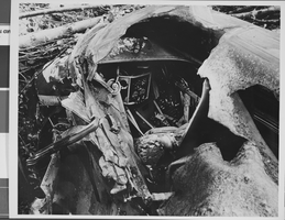
A view of the near-fatal crash of Howard Hughes' XF-11 in Culver City, California.
Image
Photograph of crash of Howard Hughes' XF-11, Culver City, California, July 07, 1946
Date
1946-07-07
Archival Collection
Description
A view of the near-fatal crash of Howard Hughes' XF-11 in Culver City, California.
Image
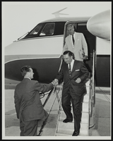
Howard Cannon visits Grumman Aircraft Engineering Plant at Bethpage, Long Island, New York: photographic print
Date
1962-08
Archival Collection
Description
From the Howard Cannon Photograph Collection (PH-00192)
Image
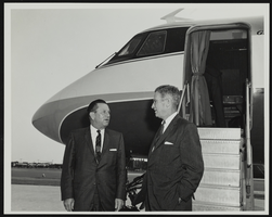
Howard Cannon visits Grumman Aircraft Engineering Plant at Bethpage, Long Island, New York: photographic print
Date
1962-08
Archival Collection
Description
From the Howard Cannon Photograph Collection (PH-00192)
Image
Howard Cannon visits Grumman Aircraft Engineering Plant at Bethpage, Long Island, New York: photographic print
Date
1962-08
Archival Collection
Description
From the Howard Cannon Photograph Collection (PH-00192)
Image
Proposed Hotel, Atlantic City Convention Center: Atlantic City, New Jersey, 1976 November 22
Level of Description
Series
Archival Collection
Martin Stern Architectural Records
To request this item in person:
Collection Number: MS-00382
Collection Name: Martin Stern Architectural Records
Box/Folder: N/A
Collection Name: Martin Stern Architectural Records
Box/Folder: N/A
Archival Component
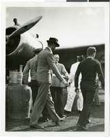
Photograph of Howard Hughes and the Lockheed 14 aircraft, Fairbanks, Alaska, July 15, 1938
Date
1938-07-15
Archival Collection
Description
The black and white view of Howard Hughes walking with other unidentified men toward the Lockheed 14 aircraft that was then being refueled. Hughes was then on his Around the World Flight where he visited Paris, Moscow, Fairbanks, and Alaska.
Image