Search the Special Collections and Archives Portal
Search Results

Photograph of the landing of Howard Hughes' Lockheed 14 aircraft, New York, July 14, 1938
Date
1938-07-14
Archival Collection
Description
The black and white, aerial view of Howard Hughes' Lockheed 14 aircraft after performing its final landing on the Round the World flight at Floyd Bennett Airport, New York.
Image
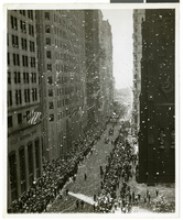
Photograph of a parade procession, New York, July 15, 1938
Date
1938-07-15
Archival Collection
Description
An overhead view of people looking up and waving during a parade procession.
Image
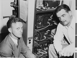
Photograph of Howard Hughes installing radar, Culver City, California, May 03, 1947
Date
1947-05-03
Archival Collection
Description
Description given with photo: "Radar Installed on Passenger Planes Culver City, Calif. -- Radar safety control system (cabinet, left, center) for passenger planes, demonstrated by Howard Hughes in a trans-world airline plane, at Culver City, May 1st. Radar, with 500 and 2,000 foot warning signals, tells the pilot when he is approaching obstacles. Equipment is being installed in planes flying routes from San Francisco eastward to Shanghai. Credit (ACME) 5/3/47."
Image
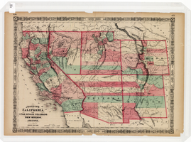
Map of California, Utah, Nevada, Colorado, New Mexico and Arizona, 1864
Date
1864
Description
'Johnson's California, with Utah, Nevada, Colorado, New Mexico, and Arizona, published by Johnson and Ward.' 'Entered according to Act of Congress in the Year 1864 by A.J. Johnson in the Clerks Office of the District Court of the United States for the southern district of New York.' Atlas page numbers in upper margin: 66-67. This is probably plate 67 from Johnson's New Illustrated Family Atlas, published in New York by Johnson & Ward in 1864. Shows natural features, locations of Indian tribes, proposed railroad routes, routes of explorers, trails, county boundaries and populated places ; "." ; Relief shown by hachures ; Prime meridians: Greenwich and Washington ; In top margin: 66-67 ; Hand colored ; On verso: Historical and statistical view of Mexico and central America (p. 79) and Historical and statistical view of the United States, 1860 (p. 78) Scale [ca. 1:3,484,800]. 1 in. to ca. 55 miles (W 124°--W 102°/N 42°--N 32°)
Text
Crowd gathered for the Howard Hughes parade, 1938 July 15
Level of Description
File
Archival Collection
Howard Hughes Public Relations Photograph Collection
To request this item in person:
Collection Number: PH-00373
Collection Name: Howard Hughes Public Relations Photograph Collection
Box/Folder: Folder 10
Collection Name: Howard Hughes Public Relations Photograph Collection
Box/Folder: Folder 10
Archival Component
Howard Hughes in Grover Whalen's car, 1938 July 15
Level of Description
File
Archival Collection
Howard Hughes Public Relations Photograph Collection
To request this item in person:
Collection Number: PH-00373
Collection Name: Howard Hughes Public Relations Photograph Collection
Box/Folder: Folder 11
Collection Name: Howard Hughes Public Relations Photograph Collection
Box/Folder: Folder 11
Archival Component
Howard Hughes during parade procession, 1938 July 15
Level of Description
File
Archival Collection
Howard Hughes Public Relations Photograph Collection
To request this item in person:
Collection Number: PH-00373
Collection Name: Howard Hughes Public Relations Photograph Collection
Box/Folder: Folder 11
Collection Name: Howard Hughes Public Relations Photograph Collection
Box/Folder: Folder 11
Archival Component
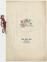
The New Fay Easter dinner menu, Sunday, April 7, 1912
Date
1912-04-07
Archival Collection
Description
Restaurant: The New Fay (Virginia, Minn.) Location: Virginia, Minnesota, United States
Text

Photograph of the landing of Howard Hughes' Lockheed 14 aircraft, New York, July 14, 1938
Date
1938-07-14
Archival Collection
Description
The black and white, aerial view of Howard Hughes' Lockheed 14 aircraft after performing its final landing on the Round the World flight at Floyd Bennett Airport, New York. Typed onto a piece of paper attached to the image: "Crowd greeting Howard Hughes and crew at floyd Bennett Airport after completing Round-the-World flight."
Image
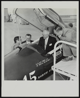
Howard Cannon and others examining an X-15 aircraft at Air Force Ballistic Missile Headquarters: photographic print
Date
1963-10-26
Archival Collection
Description
From the Howard Cannon Photograph Collection (PH-00192)
Image
Pagination
Refine my results
Content Type
Creator or Contributor
Subject
Archival Collection
Digital Project
Resource Type
Year
Material Type
Place
Language
Records Classification
