Search Results
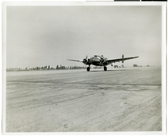
Photograph of the Lockheed 14, July, 3, 1938
Date
1938-07-03
Archival Collection
Description
Howard Hughes taking off in the Lockheed 14 aircraft. Typed on a piece of paper attached to the image: "Howard Hughes' plane taking off from Union Air Terminal July 3, 1938, on first left of round-the-world flight. Released for personal use only. Not to be reprinted or employed commercially without the permission of the undersigned. L. A. Times New Bureau."
Image
Simon, Howard, downtown apartment, 1972 November 15
Level of Description
File
Archival Collection
Frank Mitrani Photographs
To request this item in person:
Collection Number: PH-00332
Collection Name: Frank Mitrani Photographs
Box/Folder: Box 06
Collection Name: Frank Mitrani Photographs
Box/Folder: Box 06
Archival Component
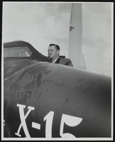
Howard Cannon in an X-15 aircraft at the World Congress of Flight, Las Vegas, Nevada: photographic print
Date
1959-04-12 (approximate) to 1959-04-19 (approximate)
Archival Collection
Description
From the Howard Cannon Photograph Collection (PH-00192)
Image

Map of California, with territories of Utah, Nevada, Colorado, New Mexico, and Arizona, 1864
Date
1864
Description
40 x 62 cm. Relief shown by hachures. Prime meridians: Greenwich and Washington. Page numbers at top: 58-59. "Entered according to act of Congress in the year 1864 by A. J. Johnson in the Clerk's Office of the District Court of the United States for the Southern District of New York." Original publisher: Johnson and Ward.
Image
Howard Hughes and co-pilot Joseph Bartles at the controls of their Lockheed Constellation after landing at LaGuardia Field in New York City, 1946 February 15
Level of Description
File
Archival Collection
Howard Hughes Public Relations Photograph Collection
To request this item in person:
Collection Number: PH-00373
Collection Name: Howard Hughes Public Relations Photograph Collection
Box/Folder: Folder 20
Collection Name: Howard Hughes Public Relations Photograph Collection
Box/Folder: Folder 20
Archival Component
Samuels, Howard J., "The Off-track Betting Experiment in New York", 1973
Level of Description
File
Archival Collection
Eugene Martin Christiansen Papers
To request this item in person:
Collection Number: MS-00561
Collection Name: Eugene Martin Christiansen Papers
Box/Folder: Box 089
Collection Name: Eugene Martin Christiansen Papers
Box/Folder: Box 089
Archival Component
Howard Hughes shaking the hand of a pilot of the airliner he was boarding that was heading to Washington, 1938 July 20
Level of Description
File
Archival Collection
Howard Hughes Public Relations Photograph Collection
To request this item in person:
Collection Number: PH-00373
Collection Name: Howard Hughes Public Relations Photograph Collection
Box/Folder: Folder 13
Collection Name: Howard Hughes Public Relations Photograph Collection
Box/Folder: Folder 13
Archival Component
Howard Hughes at a banquet held for him in the Biltmore Hotel in Los Angeles, California, 1938 August 01
Level of Description
File
Archival Collection
Howard Hughes Public Relations Photograph Collection
To request this item in person:
Collection Number: PH-00373
Collection Name: Howard Hughes Public Relations Photograph Collection
Box/Folder: Folder 16
Collection Name: Howard Hughes Public Relations Photograph Collection
Box/Folder: Folder 16
Archival Component

Map of California, Utah, Nevada, Colorado, New Mexico and Arizona, 1864
Date
1864
Description
'Johnson's California, with Utah, Nevada, Colorado, New Mexico, and Arizona, published by Johnson and Ward.' 'Entered according to Act of Congress in the Year 1864 by A.J. Johnson in the Clerks Office of the District Court of the United States for the southern district of New York.' Atlas page numbers in upper margin: 66-67. This is probably plate 67 from Johnson's New Illustrated Family Atlas, published in New York by Johnson & Ward in 1864. Shows natural features, locations of Indian tribes, proposed railroad routes, routes of explorers, trails, county boundaries and populated places ; "." ; Relief shown by hachures ; Prime meridians: Greenwich and Washington ; In top margin: 66-67 ; Hand colored ; On verso: Historical and statistical view of Mexico and central America (p. 79) and Historical and statistical view of the United States, 1860 (p. 78) Scale [ca. 1:3,484,800]. 1 in. to ca. 55 miles (W 124°--W 102°/N 42°--N 32°)
Text

Map of the territories of New Mexico, Arizona, Colorado, Nevada, and Utah, 1855
Date
1855
Description
29 x 36 cm. Relief shown by hachures. Prime meridians: Greenwich and Washington. "Entered according to act of Congress in the year 1855 by J.H. Colton & Co. in the Clerk's Office of the Dist. Office of the U.S. for the Southern. Dist. of New York." Hand colored. Decorative border. Atlas p. number in lower-right margin: 67. Shows routes of explorers, proposed railroad routes, wagon route, mail route, Indian reserves and mines. On verso: History and statistical view of Mexico. Original publisher: J.H. Colton.
Image