Search Results
New York reception for Howard Hughes and his four crew members after they completed an around-the-world flight, 1938 July 15
Level of Description
File
Archival Collection
Howard Hughes Public Relations Photograph Collection
To request this item in person:
Collection Number: PH-00373
Collection Name: Howard Hughes Public Relations Photograph Collection
Box/Folder: Folder 10
Collection Name: Howard Hughes Public Relations Photograph Collection
Box/Folder: Folder 10
Archival Component
Howard Hughes and his crew at a parade after he completed his around-the-world flight in New York, 1938 July 15
Level of Description
File
Archival Collection
Howard Hughes Public Relations Photograph Collection
To request this item in person:
Collection Number: PH-00373
Collection Name: Howard Hughes Public Relations Photograph Collection
Box/Folder: Folder 10
Collection Name: Howard Hughes Public Relations Photograph Collection
Box/Folder: Folder 10
Archival Component

Photograph of Howard Hughes at Floyd Bennett Airfield, New York, July 14, 1938
Date
1938-07-14
Archival Collection
Description
The view of a crowd of people watch Howard Hughes walk through Floyd Bennett Airfield in New York. Description printed on photograph's accompanying sheet of paper: "A scene at Floyd Bennett Field as Howard Hughes and his crew landed after completing a round the world hop. 7-14-38 (Press Association)."
Image
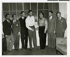
Photograph of Howard Hughes and other men, New York, July 14, 1938
Date
1938-07-14
Archival Collection
Description
Description printed on back of photograph: "At Grover Whalen's home, 48 Washington Mews [sic]. From left to right: L. Thomas Thurlow, Comm. Hl Flannigan, Edward Lund, Howard Hughes, Grover Whalen, R. Stoddart, and Harry Connor. 6/38."
Image
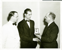
Photograph of Howard Hughes and Col. Moss, New York, July 20, 1938
Date
1938-07-20
Archival Collection
Description
Handwritten on the back of the image: "Col. Moss, Pres-Gen. of U. S. Flag Association, presenting Cross of Honor at World's Fair dinner. 7/20/38."
Image
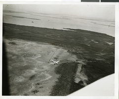
Photograph of the landing of Howard Hughes' Lockheed 14 aircraft, New York, July 14, 1938
Date
1938-07-14
Archival Collection
Description
The black and white, aerial view of Howard Hughes' Lockheed 14 aircraft preparing for its final landing on its Round the World flight in Floyd Bennett Field, New York. Typed onto a piece of paper attached to the image: "Aerial New of landing, 7-14-38. (Daily News.)" Typed onto a second piece of paper attached to the image: "Howard Hughes plane from a welcoming plane as the Round the World flight ended at Floyd Bennett Field."
Image