Search Results
Hall, Beverly J, "Creativity: Children's Creative Writing, and Teacher Evaluation", 1976 July
Level of Description
Item
Archival Collection
University of Nevada, Las Vegas Theses, Dissertations, and Honors Papers
To request this item in person:
Collection Number: UA-00082
Collection Name: University of Nevada, Las Vegas Theses, Dissertations, and Honors Papers
Box/Folder: Box 435
Collection Name: University of Nevada, Las Vegas Theses, Dissertations, and Honors Papers
Box/Folder: Box 435
Archival Component

Map of California, Utah, Nevada, Colorado, New Mexico and Arizona, 1864
Date
1864
Description
'Johnson's California, also Utah, Nevada, Colorado, New Mexico, and Arizona, published by A.J. Johnson, New York.' 'Entered according to Act of Congress in the Year 1864, by A.J. Johnson in the Clerks Office of the District Court of the United States for the Southern District of New York.' Atlas page numbers in upper margin: 66-67. Relief shown by hachures. Prime meridians: Greenwich and Washington, D.C. Shows proposed railroads, locations of Indian tribes, natural features, counties, mines, mail routes, trails and routes of exploring expeditions. On verso: History and statistics of Mexico and Central America and statistics of national finances and the Post Office of the United States, 1860. Scale [ca. 1:3,484,800. 1 in. to ca. 55 miles] (W 123°--W 103°/N 42°--N 32°)
Text
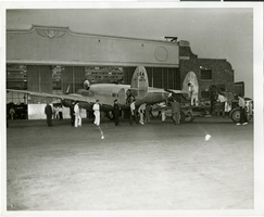
Photograph of people surrounding the Lockheed 14 aircraft, New York, July 9, 1938
Date
1938-07-09
Archival Collection
Description
The black and white view of unidentified people surrounding the Lockheed 14 aircraft. Typed on a piece of paper attached to the image: "Rolling Howard Hughes' plane out of hangar at Floyd Bennett Field, with Lt. Thomas Thurlow, one of the navigators, calibrating the compass. 7/9/38."
Image
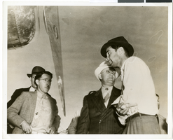
Photograph of Howard Hughes and three men, Minneapolis, Minnesota, July 14, 1938
Date
1938-07-14
Archival Collection
Description
The black and white view of Howard Hughes (far right) and three unidentified men standing in front of the Lockheed 14 aircraft after landing.
Image
Howard Hughes and Mayor Fiorello La Guardia seated in their parade car as Grover Whalen enters it just before the procession gets underway, 1938 July 15
Level of Description
File
Archival Collection
Howard Hughes Public Relations Photograph Collection
To request this item in person:
Collection Number: PH-00373
Collection Name: Howard Hughes Public Relations Photograph Collection
Box/Folder: Folder 13
Collection Name: Howard Hughes Public Relations Photograph Collection
Box/Folder: Folder 13
Archival Component
#67675: UNLV-TV Studios Inside Greenspun Hall, 2010 July 28
Level of Description
File
Archival Collection
University of Nevada, Las Vegas Creative Services Records (2010s)
To request this item in person:
Collection Number: PH-00388-05
Collection Name: University of Nevada, Las Vegas Creative Services Records (2010s)
Box/Folder: Digital File 00
Collection Name: University of Nevada, Las Vegas Creative Services Records (2010s)
Box/Folder: Digital File 00
Archival Component
Holiday Inn Hotel and Casino, Marina Associates:, 1979 November 15; 1980 July 15
Level of Description
Series
Archival Collection
Martin Stern Architectural Records
To request this item in person:
Collection Number: MS-00382
Collection Name: Martin Stern Architectural Records
Box/Folder: N/A
Collection Name: Martin Stern Architectural Records
Box/Folder: N/A
Archival Component

Letter from A. S. Halsted to W. H. Comstock, July 15, 1922
Date
1922-07-15
Archival Collection
Description
Halsted advises on legal interpretations of use of force in guarding railroad property.
Text

Savoy Restaurant menu, June 15, 1898
Date
1898-06-15
Archival Collection
Description
Note: Handwritten menu. "Déposé [registered] AD" [printer's monogram] printed under illustration on page 2. Illustration on page 2 shows a woman wearing a toga and sandals, with a raised wine glass and a scepter, riding atop a barrel being pulled by two oversized snails Restaurant: Savoy Restaurant
Text
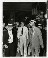
Photograph of Howard Hughes being escorted into the Rico Hotel, Houston, Texas, July 30, 1938
Date
1938-07-30
Archival Collection
Description
Howard Hughes (center) is escorted into the lobby of the Rico Hotel, Houston, Texas
Image