Search Results
Unidentified group of people standing outside of a house, Rochester, New York: photographic print, approximately 1880 to 1899
Level of Description
Item
Archival Collection
Leon Rockwell Photograph Collection
To request this item in person:
Collection Number: PH-00008
Collection Name: Leon Rockwell Photograph Collection
Box/Folder: Oversized Box SH-054 (Restrictions apply)
Collection Name: Leon Rockwell Photograph Collection
Box/Folder: Oversized Box SH-054 (Restrictions apply)
Archival Component
Don Schlesinger interview, taped over the phone from Bardonia, New York with Ruchman, approximately 1999 to 2001
Level of Description
File
Archival Collection
Penelope Ruchman Collection of Las Vegas, Nevada Casino Professionals Oral Histories
To request this item in person:
Collection Number: MS-00907
Collection Name: Penelope Ruchman Collection of Las Vegas, Nevada Casino Professionals Oral Histories
Box/Folder: Box 01, Digital File 00
Collection Name: Penelope Ruchman Collection of Las Vegas, Nevada Casino Professionals Oral Histories
Box/Folder: Box 01, Digital File 00
Archival Component
Resorts International Hotel: Atlantic City, New Jersey, 1982-07-22
Level of Description
Series
Archival Collection
Martin Stern Architectural Records
To request this item in person:
Collection Number: MS-00382
Collection Name: Martin Stern Architectural Records
Box/Folder: N/A
Collection Name: Martin Stern Architectural Records
Box/Folder: N/A
Archival Component

Map of the city of Las Vegas, Nevada, June 1, 1946
Date
1946-06-01
Description
Scale [ca. 1:9,600. 1 in. to approx. 800 ft.]. Cadastral map. 'Compiled by Pioneer Title Insurance &Trust Company.' 'By Jack Asher, State Nev. Reg. Engr. No. 305.' 'Issue 5, 6/1/46.' Includes indexes. Pioneer Title Insurance &
Trust Company
Trust Company
Image

Map of California, territories of New Mexico, Arizona, Colorado, Nevada and Utah, circa 1863
Date
1861 to 1865
Description
40 x 62 cm. Relief shown by hachures and spot heights. Prime meridians: Greenwich and Washington. "Historical and statistical view of the United States, 1860"--Verso. Atlas page numbers at top: 58-59. Arizona became a territory in 1863, and Nevada became a state on October 31, 1864, so this map was either published in 1863 or in 1864 before the end of October. Original publisher: Johnson and Ward.
Image
T-Shirt Color: White; Front: New York State Old Fashioned Tournament Engine 4 2000 RVCFD Champions, Fire Emblem W/Fire Equip; Back: RVC Woodlands 2000 New York State Old Fashioned Tournament Champions, NY State, approximately 2001-2012
Level of Description
File
Archival Collection
New York-New York Hotel and Casino 9-11 Heroes Tribute Collection
To request this item in person:
Collection Number: MS-00459
Collection Name: New York-New York Hotel and Casino 9-11 Heroes Tribute Collection
Box/Folder: Box 416
Collection Name: New York-New York Hotel and Casino 9-11 Heroes Tribute Collection
Box/Folder: Box 416
Archival Component
Sahara Boardwalk, Atlantic City, New Jersey, 1980; 1980 July 14
Level of Description
Series
Archival Collection
Martin Stern Architectural Records
To request this item in person:
Collection Number: MS-00382
Collection Name: Martin Stern Architectural Records
Box/Folder: N/A
Collection Name: Martin Stern Architectural Records
Box/Folder: N/A
Archival Component
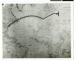
Photograph of a flight path map, 1938
Date
1938
Archival Collection
Description
Description printed on back of photograph: "Map of Howard Hughes' flight."
Image
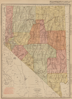
Rand-McNally new commercial atlas map of Nevada, 1912
Date
1912
Description
Original publisher: Rand, McNally & Co. Scale [ca. 1:1,203,840). 1 inch to 19 miles. Originally published as p. 316-317 of Rand McNally's commercial atlas of America. Title in right margin: Nevada : commercial atlas of America. Includes township and range grid. Includes index to Nevada railroads and index to principal cities with their populations. Index on verso to counties, towns and natural features in Oregon and Nevada.
Image
Valley of Fire, Mount Charleston, Lost City, and Fremont Street, 1937 November 26-1938 February 14
Level of Description
File
Archival Collection
Robert Woodruff Papers
To request this item in person:
Collection Number: MS-00455
Collection Name: Robert Woodruff Papers
Box/Folder: Box 08
Collection Name: Robert Woodruff Papers
Box/Folder: Box 08
Archival Component