Search Results

Map of California and territories of New Mexico and Utah, circa 1861
Date
1856 to 1866
Description
40 x 60 cm. Relief shown by hachures and spot heights. Prime meridians: Greenwich and Washington. Atlas plate numbers 54 and 55 in the upper corners. Shows forts, trails, exploration routes, drainage, mail steamship routes, physical features, Indian tribes, and historic sites. The geographic region of Southwest is referred to as the New Southwest. Original publisher: Johnson .
Image
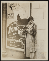
Grace Hayes in front of a playbill posted on the 44th Street Theatre in New York: photographic print
Date
1927
Archival Collection
Description
Grace Hayes in front of a playbill posted on the 44th Street Theatre in New York. She is wearing a patterned coat and small black hat and is holding a small dog.
Image

Map of California, Utah, Nevada, Colorado, New Mexico and Arizona, 1864
Date
1864
Description
'Johnson's California, with Utah, Nevada, Colorado, New Mexico, and Arizona, published by Johnson and Ward.' 'Entered according to Act of Congress in the Year 1864 by A.J. Johnson in the Clerks Office of the District Court of the United States for the southern district of New York.' Atlas page numbers in upper margin: 66-67. This is probably plate 67 from Johnson's New Illustrated Family Atlas, published in New York by Johnson & Ward in 1864. Shows natural features, locations of Indian tribes, proposed railroad routes, routes of explorers, trails, county boundaries and populated places ; "." ; Relief shown by hachures ; Prime meridians: Greenwich and Washington ; In top margin: 66-67 ; Hand colored ; On verso: Historical and statistical view of Mexico and central America (p. 79) and Historical and statistical view of the United States, 1860 (p. 78) Scale [ca. 1:3,484,800]. 1 in. to ca. 55 miles (W 124°--W 102°/N 42°--N 32°)
Text
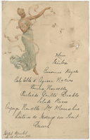
Hôtel Bristol menu, February 15, 1890
Date
1890-02-15
Archival Collection
Description
Note: Handwritten menu Restaurant: Hôtel Bristol
Text
Lottery ticket from Honduras National Lottery Company in Louisiana; lottery ticket-beneficencia; New York state lottery advertisement; New York state Olympic lottery, 1904-1979
Level of Description
File
Archival Collection
UNLV University Libraries Collection on International Lotteries
To request this item in person:
Collection Number: MS-00619
Collection Name: UNLV University Libraries Collection on International Lotteries
Box/Folder: Oversized Box 01
Collection Name: UNLV University Libraries Collection on International Lotteries
Box/Folder: Oversized Box 01
Archival Component
New York World's Fair visit. Includes correspondence and various supplemental materials, 1964
Level of Description
File
Archival Collection
Howard Cannon Papers
To request this item in person:
Collection Number: MS-00002
Collection Name: Howard Cannon Papers
Box/Folder: Box 03 (Trips)
Collection Name: Howard Cannon Papers
Box/Folder: Box 03 (Trips)
Archival Component
Salk, M. S.; Tolbert, V.R.; and Dickerman, J.A. 1999. "Guidelines and Techniques for Improving the NEPA Process." Environmental Management. 23, (4). 467-476. New York, New York: Springer-Verlag, 1999
Level of Description
File
Archival Collection
Environmental Radiation Protection Standards for Yucca Mountain, Nevada
To request this item in person:
Collection Number: MS-00603
Collection Name: Environmental Radiation Protection Standards for Yucca Mountain, Nevada
Box/Folder: Box 44
Collection Name: Environmental Radiation Protection Standards for Yucca Mountain, Nevada
Box/Folder: Box 44
Archival Component
Davies. J. B., and C. B. Archambeau, 1997, "Geohydrological models and earthquake effects at Yucca Mountain, Nevada," Environmental Geology, Volume 32. Number 1. pp. 23-35. New York, New York, 1997
Level of Description
File
Archival Collection
Environmental Radiation Protection Standards for Yucca Mountain, Nevada
To request this item in person:
Collection Number: MS-00603
Collection Name: Environmental Radiation Protection Standards for Yucca Mountain, Nevada
Box/Folder: Box 05
Collection Name: Environmental Radiation Protection Standards for Yucca Mountain, Nevada
Box/Folder: Box 05
Archival Component
Florman, Samuel C. Gee, This is Magnificent, New York Times Magazine, 1989 February 12
Level of Description
File
Archival Collection
UNLV Libraries Collection of Articles on Gaming and Las Vegas, Nevada Topics
To request this item in person:
Collection Number: MS-00626
Collection Name: UNLV Libraries Collection of Articles on Gaming and Las Vegas, Nevada Topics
Box/Folder: Box 15
Collection Name: UNLV Libraries Collection of Articles on Gaming and Las Vegas, Nevada Topics
Box/Folder: Box 15
Archival Component