Search Results
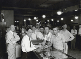
Photograph of Laubach's Recreation Tavern, Boulder City, Nevada, July 1932
Date
1932-07
Archival Collection
Description
An inside view of Laubach's Recreation Tavern, Boulder City, Nevada. The only two identified individuals in the image include Jack Laubach, far left, and Guy Edward "Whataman" Hudson, positioned in the center and behind the counter.
Image
National City Bank of New York account transactions, 1932 April to 1933 February
Level of Description
File
Archival Collection
Howard Hughes Film Production Records
To request this item in person:
Collection Number: MS-01036
Collection Name: Howard Hughes Film Production Records
Box/Folder: Box 089 (Restrictions apply)
Collection Name: Howard Hughes Film Production Records
Box/Folder: Box 089 (Restrictions apply)
Archival Component
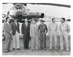
Photograph of Howard Hughes with XH-17 helicopter, Culver City, California, October 23, 1952
Date
1952-10-23
Archival Collection
Description
L-R: Rea Hopper, Director of the Aeronautical Division, Hughes Aircraft Company; Howard Hughes; Clyde Jones, Director of Engineering, Hughes Tool Company Aeronautical Division; Warren Reed, Assistant; Col. Carl E. Jackson, Air Research and Development Headquarters, Baltimore; Gale J. Moore, pilot; and unidentified pilot in front of the experimental helicopter XH-17 Flying Crane on October 23, 1952. This was one of Hughes' last public appearances.
Image
Aid to New York City. Contains memo to HWC from Aubrey, 1975 December
Level of Description
File
Archival Collection
Howard Cannon Papers
To request this item in person:
Collection Number: MS-00002
Collection Name: Howard Cannon Papers
Box/Folder: Box 03 (Las Vegas files)
Collection Name: Howard Cannon Papers
Box/Folder: Box 03 (Las Vegas files)
Archival Component
Third Avenue, New York by John McNulty, 1946 July
Level of Description
File
Archival Collection
Beverly Rogers Collection of Armed Services Editions
To request this item in person:
Collection Number: MS-00913
Collection Name: Beverly Rogers Collection of Armed Services Editions
Box/Folder: Box 05
Collection Name: Beverly Rogers Collection of Armed Services Editions
Box/Folder: Box 05
Archival Component
Hilton Hotel and Casino: Atlantic City, New Jersey, 1980 March 31
Level of Description
Series
Archival Collection
Martin Stern Architectural Records
To request this item in person:
Collection Number: MS-00382
Collection Name: Martin Stern Architectural Records
Box/Folder: N/A
Collection Name: Martin Stern Architectural Records
Box/Folder: N/A
Archival Component

Map of city of Las Vegas, Nevada, October 1, 1940
Date
1940-10-01
Description
'Compiled by C.D. Baker, Oct. 1, 1940.' Scale [ca. 1:11,400]. 1 in. to 950 ft. Cadastral map.
Image
Resorts International Hotel: Atlantic City, New Jersey, 1982-07-22
Level of Description
Series
Archival Collection
Martin Stern Architectural Records
To request this item in person:
Collection Number: MS-00382
Collection Name: Martin Stern Architectural Records
Box/Folder: N/A
Collection Name: Martin Stern Architectural Records
Box/Folder: N/A
Archival Component

Map of the city of Las Vegas, Nevada, June 1, 1946
Date
1946-06-01
Description
Scale [ca. 1:9,600. 1 in. to approx. 800 ft.]. Cadastral map. 'Compiled by Pioneer Title Insurance &Trust Company.' 'By Jack Asher, State Nev. Reg. Engr. No. 305.' 'Issue 5, 6/1/46.' Includes indexes. Pioneer Title Insurance &
Trust Company
Trust Company
Image

Map of California, territories of New Mexico, Arizona, Colorado, Nevada and Utah, circa 1863
Date
1861 to 1865
Description
40 x 62 cm. Relief shown by hachures and spot heights. Prime meridians: Greenwich and Washington. "Historical and statistical view of the United States, 1860"--Verso. Atlas page numbers at top: 58-59. Arizona became a territory in 1863, and Nevada became a state on October 31, 1864, so this map was either published in 1863 or in 1864 before the end of October. Original publisher: Johnson and Ward.
Image