Search the Special Collections and Archives Portal
Search Results
Howard Hughes after arriving in Minneapolis, Minnesota, 1938 July 14
Level of Description
File
Archival Collection
Howard Hughes Public Relations Photograph Collection
To request this item in person:
Collection Number: PH-00373
Collection Name: Howard Hughes Public Relations Photograph Collection
Box/Folder: Folder 08
Collection Name: Howard Hughes Public Relations Photograph Collection
Box/Folder: Folder 08
Archival Component
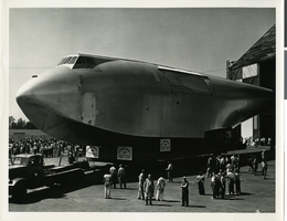
Photograph of the fuselage of the Howard Hughes' Flying Boat, Culver City, California, 1946
Date
1946
Archival Collection
Description
A section of Howard Hughes' "Spruce Goose" or "Flying Boat" being moved (with a police escort) from the Hughes Aircraft plant in Culver City, California to Terminal Island in the Los Angeles Harbor where the plane was assembled in June of 1946.
Image
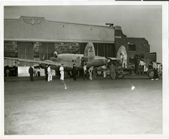
Photograph of people surrounding the Lockheed 14 aircraft, New York, July 9, 1938
Date
1938-07-09
Archival Collection
Description
The black and white view of unidentified people surrounding the Lockheed 14 aircraft. Typed on a piece of paper attached to the image: "Rolling Howard Hughes' plane out of hangar at Floyd Bennett Field, with Lt. Thomas Thurlow, one of the navigators, calibrating the compass. 7/9/38."
Image
Howard Hughes in Seattle near the tail of a Stratoliner, 1939 July 05
Level of Description
File
Archival Collection
Howard Hughes Public Relations Photograph Collection
To request this item in person:
Collection Number: PH-00373
Collection Name: Howard Hughes Public Relations Photograph Collection
Box/Folder: Folder 17
Collection Name: Howard Hughes Public Relations Photograph Collection
Box/Folder: Folder 17
Archival Component
Howard Hughes in the Lockheed 14, Wichita, Kansas, 1938 July 03
Level of Description
File
Archival Collection
Howard Hughes Public Relations Photograph Collection
To request this item in person:
Collection Number: PH-00373
Collection Name: Howard Hughes Public Relations Photograph Collection
Box/Folder: Folder 05
Collection Name: Howard Hughes Public Relations Photograph Collection
Box/Folder: Folder 05
Archival Component
"Bobby the K." interview with Ruchman, 1999 July 15
Level of Description
File
Archival Collection
Penelope Ruchman Collection of Las Vegas, Nevada Casino Professionals Oral Histories
To request this item in person:
Collection Number: MS-00907
Collection Name: Penelope Ruchman Collection of Las Vegas, Nevada Casino Professionals Oral Histories
Box/Folder: Box 01, Digital File 00
Collection Name: Penelope Ruchman Collection of Las Vegas, Nevada Casino Professionals Oral Histories
Box/Folder: Box 01, Digital File 00
Archival Component
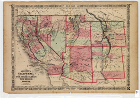
Map of California, Utah, Nevada, Colorado, New Mexico and Arizona, 1864
Date
1864
Description
'Johnson's California, also Utah, Nevada, Colorado, New Mexico, and Arizona, published by A.J. Johnson, New York.' 'Entered according to Act of Congress in the Year 1864, by A.J. Johnson in the Clerks Office of the District Court of the United States for the Southern District of New York.' Atlas page numbers in upper margin: 66-67. Relief shown by hachures. Prime meridians: Greenwich and Washington, D.C. Shows proposed railroads, locations of Indian tribes, natural features, counties, mines, mail routes, trails and routes of exploring expeditions. On verso: History and statistics of Mexico and Central America and statistics of national finances and the Post Office of the United States, 1860. Scale [ca. 1:3,484,800. 1 in. to ca. 55 miles] (W 123°--W 103°/N 42°--N 32°)
Text
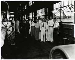
Photograph of Howard Hughes and employees at the Hughes Tool Company, Houston, Texas, July 30, 1938
Date
1938-07-30
Archival Collection
Description
Howard Hughes (second from right) and employees, visiting Hughes Tool Company in Houston Texas in 1938.
Image
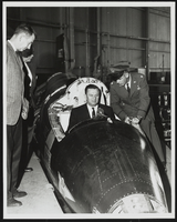
Howard Cannon in the cockpit of the X-15 with Major Robert M. White on the right: photographic print
Date
1950 (year approximate) to 1983 (year approximate)
Archival Collection
Description
From the Howard Cannon Photograph Collection (PH-00192). Stamped on verso: "Released by: Office of Information Air Force Flight Test Center Edwards Air Force Base Edwards, California".
Image
Pagination
Refine my results
Content Type
Creator or Contributor
Subject
Archival Collection
Digital Project
Resource Type
Year
Material Type
Place
Language
Records Classification
