Search Results
Coalition for Casino Gambling: plan for New York City, undated
Level of Description
File
Archival Collection
Eugene Martin Christiansen Papers
To request this item in person:
Collection Number: MS-00561
Collection Name: Eugene Martin Christiansen Papers
Box/Folder: Box 163
Collection Name: Eugene Martin Christiansen Papers
Box/Folder: Box 163
Archival Component
New York City Council news reports and correspondence, 1990
Level of Description
File
Archival Collection
Eugene Martin Christiansen Papers
To request this item in person:
Collection Number: MS-00561
Collection Name: Eugene Martin Christiansen Papers
Box/Folder: Box 163
Collection Name: Eugene Martin Christiansen Papers
Box/Folder: Box 163
Archival Component
"The Meadowlands and New York City's Harness Racing Industry", 1987
Level of Description
File
Archival Collection
Eugene Martin Christiansen Papers
To request this item in person:
Collection Number: MS-00561
Collection Name: Eugene Martin Christiansen Papers
Box/Folder: Box 049
Collection Name: Eugene Martin Christiansen Papers
Box/Folder: Box 049
Archival Component
New York City Pizza, menu, approximately 1961 to 1990
Level of Description
File
Archival Collection
UNLV University Libraries Menu Collection
To request this item in person:
Collection Number: MS-00436
Collection Name: UNLV University Libraries Menu Collection
Box/Folder: Box 35
Collection Name: UNLV University Libraries Menu Collection
Box/Folder: Box 35
Archival Component
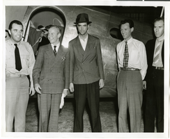
Photograph of Howard Hughes, Tom Thurlow, Harry Connor, Richard Staddart, and Dale Powers, New York, July 4, 1938
Date
1938-07-04
Archival Collection
Description
Howard Hughes, Tom Thurlow, Harry Connor, Richard Staddart, and Dale Powers with an unidentified aircraft behind them in New York. Typed on a piece of paper attached to the image: "Hughes flies to New York for hop to Paris. L to R L. Tom Thurlow and Harry Connor, Hughes, Richard Stoddart and Dale Powers. 7/4/1938."
Image
Howard Hughes's XF-11 near Culver City, California, 1946
Level of Description
File
Archival Collection
Howard Hughes Public Relations Photograph Collection
To request this item in person:
Collection Number: PH-00373
Collection Name: Howard Hughes Public Relations Photograph Collection
Box/Folder: Folder 21
Collection Name: Howard Hughes Public Relations Photograph Collection
Box/Folder: Folder 21
Archival Component
Howard Hughes's XF-11 near Culver City, California, 1946
Level of Description
File
Archival Collection
Howard Hughes Public Relations Photograph Collection
To request this item in person:
Collection Number: PH-00373
Collection Name: Howard Hughes Public Relations Photograph Collection
Box/Folder: Folder 22
Collection Name: Howard Hughes Public Relations Photograph Collection
Box/Folder: Folder 22
Archival Component