Search Results
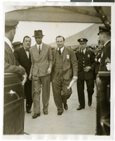
Photograph of Howard Hughes and Grover Whalen at Floyd Bennett Airfield, New York, July 14, 1938
Date
1938-07-14
Archival Collection
Description
A view of Howard Hughes being escorted by Grover Whalen and several guards at Floyd Bennett Airfield.
Image
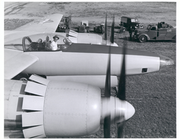
Photograph of Howard Hughes in cockpit of the XF-11, Culver City, California, July 7, 1946
Date
1946-07-07
Archival Collection
Description
Howard Hughes in the cockpit of the XF-11. Trucks and emergency vehicles are seen nearby.
Image
Edward P. Mulrooney, City of New York, New York Police Commissioner, foreword on gun control, approximately 1930 to 1931
Level of Description
File
Archival Collection
Howard Hughes Film Production Records
To request this item in person:
Collection Number: MS-01036
Collection Name: Howard Hughes Film Production Records
Box/Folder: Box 056 (Restrictions apply)
Collection Name: Howard Hughes Film Production Records
Box/Folder: Box 056 (Restrictions apply)
Archival Component
Wilbur and Toni Clark at a formal dinner at the Hotel Astor in New York City, New York, 1958
Level of Description
File
Archival Collection
Toni and Wilbur Clark Photographs
To request this item in person:
Collection Number: PH-00302
Collection Name: Toni and Wilbur Clark Photographs
Box/Folder: Folder 10
Collection Name: Toni and Wilbur Clark Photographs
Box/Folder: Folder 10
Archival Component
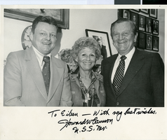
Photograph of Assemblywoman Eileen Brookman, Senator Howard Cannon and D.C. McSweeny, Nevada, March 15, 1978
Date
1978-03-15
Archival Collection
Description
The photograph depicts D.C. McSweeney, Nevada Assemblywoman Eileen Brookman and Nevada Senator Howard Cannon on the right. The photo was taken on March 15, 1978; location is unspecified. The picture is autographed to Eileen by Cannon. The inscriptions says: "To Eileen - with very best wishes. Howard Cannon, U.S.S. Nev."
Image

Photograph of a crowd of people awaiting the arrival of Howard Hughes, New York, July 14, 1938
Date
1938-07-14
Archival Collection
Description
The black and white view of members of the Aeronautical Association awaiting the arrival of Howard Hughes and his Lockheed 12 aircraft at the Floyd Bennett Airport in New York. Typed onto a piece of paper attached to the image: "Official timers of Aeronautical Association compare their precision chronometers as Lockheed-14 roars overhead, marking end of Round-the-World flight at Floyd Bennett Airport." Typed onto a second piece of paper also attached to the image: "Official timers of the Aeronautical Association shown at Floyd Bennett Field comparing their precision chronometers as Howard Hughes' plane roared overhead marking the end of his Flight Around The World. July 1938."
Image

Map of California, Utah, Nevada, Colorado, New Mexico and Arizona, 1864
Date
1864
Description
'Johnson's California, also Utah, Nevada, Colorado, New Mexico, and Arizona, published by A.J. Johnson, New York.' 'Entered according to Act of Congress in the Year 1864, by A.J. Johnson in the Clerks Office of the District Court of the United States for the Southern District of New York.' Atlas page numbers in upper margin: 66-67. Relief shown by hachures. Prime meridians: Greenwich and Washington, D.C. Shows proposed railroads, locations of Indian tribes, natural features, counties, mines, mail routes, trails and routes of exploring expeditions. On verso: History and statistics of Mexico and Central America and statistics of national finances and the Post Office of the United States, 1860. Scale [ca. 1:3,484,800. 1 in. to ca. 55 miles] (W 123°--W 103°/N 42°--N 32°)
Text
Del Webb's Sahara Boardwalk-Atlantic City, New Jersey
Level of Description
File
Archival Collection
Martin Stern Architectural Records
To request this item in person:
Collection Number: MS-00382
Collection Name: Martin Stern Architectural Records
Box/Folder: N/A
Collection Name: Martin Stern Architectural Records
Box/Folder: N/A
Archival Component
Harrah's Marina Hotel Casino: Atlantic City, New Jersey
Level of Description
Series
Archival Collection
Martin Stern Architectural Records
To request this item in person:
Collection Number: MS-00382
Collection Name: Martin Stern Architectural Records
Box/Folder: N/A
Collection Name: Martin Stern Architectural Records
Box/Folder: N/A
Archival Component
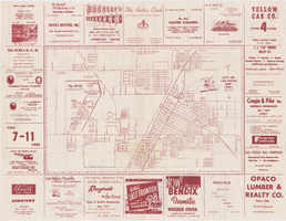
Map of the city of Las Vegas, 1953
Date
1953
Description
24 x 38 cm. on sheet 43 x 56 cm., folded to 28 x 13 cm. Includes advertisements for Las Vegas businesses. Advertisements for Las Vegas businesses, inset map of North Las Vegas, and index on verso. Copyright held by Redwood Pub. Co. Includes inset map of the Strip (U.S. 91 or Los Angeles Highway). Map is irregularly shaped. Original publisher: Redwood Pub. Co..
Image