Search Results
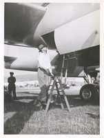
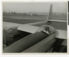
Photograph of Howard Hughes climbing into the XF-11, Culver City, California, July 7, 1946
Date
1946-07-07
Archival Collection
Description
Howard Hughes on a ladder, climbing into the XF-11. A police officer is seen in the background.
Image
Howard Hughes at Floyd Bennett Field, New York, 1938 July 09
Level of Description
File
Archival Collection
Howard Hughes Public Relations Photograph Collection
To request this item in person:
Collection Number: PH-00373
Collection Name: Howard Hughes Public Relations Photograph Collection
Box/Folder: Folder 05
Collection Name: Howard Hughes Public Relations Photograph Collection
Box/Folder: Folder 05
Archival Component
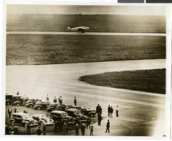
Photograph of the landing of Howard Hughes' Lockheed 14 aircraft, New York, July 14, 1938
Date
1938-07-14
Archival Collection
Description
The black and white, aerial view of Howard Hughes' Lockheed 14 aircraft performing its final landing on the Round the World flight at Floyd Bennett Airport, New York. Typed onto a piece of paper attached to the image: "Howard Hughes big silver monoplane landing at Floyd Bennett Field his afternoon completing a record flight around the world in 3 days, 13 hours, and 17 minutes. 7/14/38 (Press Association)."
Image
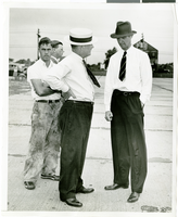
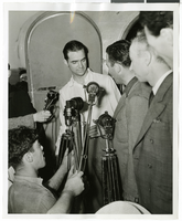
Photograph of Howard Hughes and W.D. "Jim" Guthrive at Roosevent Field, New York, July 18, 1938
Date
1938-07-18
Archival Collection
Description
Handwritten on the back of the image: "Talking to W.D. "Jim" Guthrive at Roosevelt Field. 7/18/38."
Image
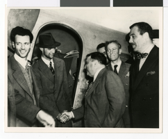
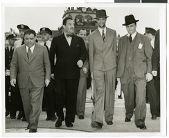
Photograph of Howard Hughes with Fiorello La Guardia and Grover Whalen, New York, July 12, 1938
Date
1938-07-12
Archival Collection
Description
Howard Hughes (wearing hat) receives congratulations from Mayor Fiorello La Guardia at Floyd Bennett Airport in Brooklyn. The gentleman wearing a polka dot bow tie, standing behind the mayor is Grover Whalen. Mr. Whalen was president of the 1939 New York World's Fair.
Image
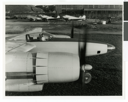
Photograph of Howard Hughes in the cockpit of the first XF-11, Culver City, California, 1946
Date
1946
Archival Collection
Description
Howard Hughes in the cockpit of his XF-11 before its first test flight.
Image

Map of California, Utah, Nevada, Colorado, New Mexico and Arizona, 1864
Date
1864
Description
'Johnson's California, with Utah, Nevada, Colorado, New Mexico, and Arizona, published by Johnson and Ward.' 'Entered according to Act of Congress in the Year 1864 by A.J. Johnson in the Clerks Office of the District Court of the United States for the southern district of New York.' Atlas page numbers in upper margin: 66-67. This is probably plate 67 from Johnson's New Illustrated Family Atlas, published in New York by Johnson & Ward in 1864. Shows natural features, locations of Indian tribes, proposed railroad routes, routes of explorers, trails, county boundaries and populated places ; "." ; Relief shown by hachures ; Prime meridians: Greenwich and Washington ; In top margin: 66-67 ; Hand colored ; On verso: Historical and statistical view of Mexico and central America (p. 79) and Historical and statistical view of the United States, 1860 (p. 78) Scale [ca. 1:3,484,800]. 1 in. to ca. 55 miles (W 124°--W 102°/N 42°--N 32°)
Text
Howard Hughes in cockpit of the first XF-11, Culver City, California, July 7, 1946
Date
1946-07-07
Archival Collection
Description
Howard Hughes warming up the first XF-11 prototype.
Image
Photograph of Howard Hughes and Grover Whalen at Floyd Bennett Field, New York, July 10, 1938
Date
1938-07-10
Archival Collection
Description
The black and white view of Howard Hughes and Grover Whalen at Floyd Bennett Airport just before Hughes takes off for Paris.
Image
Photograph of Howard Hughes and Grover Whalen at Floyd Bennett Airfield, New York, July 14, 1938
Date
1938-07-14
Archival Collection
Description
A view of Howard Hughes and Grover Whalen leaving Floyd Bennett Airfield.
Image