Search Results

Photograph of a crowd of people awaiting the arrival of Howard Hughes, New York, July 14, 1938
Date
1938-07-14
Archival Collection
Description
The black and white view of a crowd of people awaiting the arrival of Howard Hughes in his Lockheed 14 aircraft at Floyd Bennett Airport, New York. This final landing for Hughes marked the end of his Round The World flight.
Image
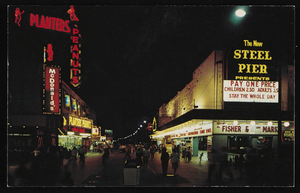
Nighttime view of Atlantic City, New Jersey: postcard
Date
1940 (year approximate) to 1990 (year approximate)
Archival Collection
Description
From Harvey's Hotel and Casino Postcard Collection (PH-00367)
Image

Photograph of a contract signing at City Hall, Las Vegas (Nev.), August 25, 1967
Date
1967-08-25
Archival Collection
Description
Signing of contracts for Lake Mead water pipeline at the Las Vegas City Hall. Sitting in the top row from left to right: unidentified individual, Arleigh West, Bureu of Reclamation, Oran Gragson, Mayor of Las Vegas, Paul Laxalt, Governor of Nevada, Robert Griffith, Chairman Colorado River Commission, William Taylor, Mayor of North Las Vegas, Leonard Fayle, President of Las Vegas Valley Water District, Mr. Hampton, Mayor of Henderson, Robert Broadbent, Mayor of Boulder City. Site Name: Clark County Court House, Las Vegas (Nev.)
Image

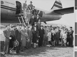
Photograph of the landing of Howard Hughes' Lockheed 14 aircraft, New York, July 14, 1938
Date
1938-07-14
Archival Collection
Description
The black and white view of Howard Hughes' Lockheed 14 aircraft performing its final landing on the Round the World flight at Floyd Bennett Airport, New York. Typed onto a piece of paper attached to the image: "Scene at Floyd Bennett Field as Howard Hughes and his crew landed after completing a round the world flight..... 7-14-38. (Press Association)"
Image

Photograph of the landing of Howard Hughes' Lockheed 14 aircraft, New York, July 14, 1938
Date
1938-07-14
Archival Collection
Description
The black and white, view of Howard Hughes' Lockheed 14 aircraft performing its final landing on the Round the World flight at Floyd Bennett Airport, New York. Typed onto a piece of paper attached to the image: "Scene at Floyd Bennett Field as Howard Hughes and his crew landed after completing a round the world flight..... 7-14-38. (Press Association)"
Image
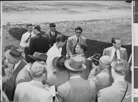
Photograph of Howard Hughes installing radar, Culver City, California, May 03, 1947
Date
1947-05-03
Archival Collection
Description
A view of Howard Hughes conversing with an unidentified group of people in Calfornia.
Image
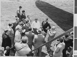
Photograph of Howard Hughes installing radar, Culver City, California, May 03, 1947
Date
1947-05-03
Archival Collection
Description
A view of Howard Hughes conversing with an unidentified group of people in California.
Image
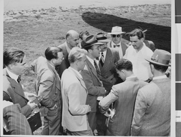
Photograph of Howard Hughes installing radar, Culver City, California, May 03, 1947
Date
1947-05-03
Archival Collection
Description
A view of Howard Hughes conversing with an unidentified group of people in California.
Image
Photograph of Howard Hughes installing radar, Culver City, California, May 03, 1947
Date
1947
Archival Collection
Description
A view of Howard Hughes conversing with an unidentified group of people in Calfornia.
Image
Music Hall New Years Eve Gala Dinner 1969-1970, menu, 1969
Level of Description
File
Archival Collection
UNLV University Libraries Menu Collection
To request this item in person:
Collection Number: MS-00436
Collection Name: UNLV University Libraries Menu Collection
Box/Folder: Box 13
Collection Name: UNLV University Libraries Menu Collection
Box/Folder: Box 13
Archival Component