Search Results
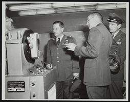
Howard Cannon during visit to Holloman Air Force Base, New Mexico with two other men: photographic print
Date
1964
Archival Collection
Description
From the Howard Cannon Photograph Collection (PH-00192). Stamped on verso: "Official Air Force Photo - Base Photo Branch - Holloman AFB, New Mexico"
Image
Las Vegas, city of, parcel of land adjoining American Legion Hall, 1962
Level of Description
File
Archival Collection
Elmo C. Bruner Architectural and Real Estate Appraisal Records
To request this item in person:
Collection Number: MS-00177
Collection Name: Elmo C. Bruner Architectural and Real Estate Appraisal Records
Box/Folder: Box 06
Collection Name: Elmo C. Bruner Architectural and Real Estate Appraisal Records
Box/Folder: Box 06
Archival Component
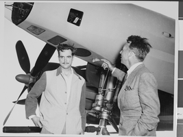
Photograph of Howard Hughes with Senator Harry P. Cain, Culver City, California, August 16, 1947
Date
1947-08-16
Archival Collection
Description
A view of Howard Hughes (left) being asked about his controversial XF-11 photo reconnaissance plane by Senator Harry Cain (right), Republican of Washington, in Culver City, California.
Image
Negative: Oran K. Gragson in his office at City Hall, 1961 December 21
Level of Description
File
Archival Collection
Oran K. Gragson Photographs
To request this item in person:
Collection Number: PH-00310
Collection Name: Oran K. Gragson Photographs
Box/Folder: Box SH-032
Collection Name: Oran K. Gragson Photographs
Box/Folder: Box SH-032
Archival Component
#65841: Howard, Lisa (IT Tech) - New Faces Article, 2007 August 27
Level of Description
File
Archival Collection
University of Nevada, Las Vegas Creative Services Records (2000s)
To request this item in person:
Collection Number: PH-00388-04
Collection Name: University of Nevada, Las Vegas Creative Services Records (2000s)
Box/Folder: N/A
Collection Name: University of Nevada, Las Vegas Creative Services Records (2000s)
Box/Folder: N/A
Archival Component
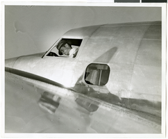
Photograph of Howard Hughes in his Lockheed 14 aircraft, Floyd Bennett Field, New York, July 10, 1938
Date
1938-07-10
Archival Collection
Description
The black and white view of Howard Hughes in his Lockheed 14 aircraft at Floyd Bennett Field in New York. Text printed on accompanying paper strip: "Hughes takes off on flight to Paris. Floyd Bennett Field, New York City-- Howard Hughes, multi-millionaire speed flyer, pictured in the nose of his Hughes Lockheed "Flying Laboratory" as Hughes and his picked crew of four prepared for the take-off to Paris and probably around the world on July 10th. A few minutes after this picture was taken, the giant ship lifted from the field to follow the trail blazed by Chrales A. Lindbergh. Credit Line (ACME) 7/10/38."
Image
Photograph Howard Hughes arrival at Floyd Bennett Airport, New York, July 14, 2013
Date
1938-07-14
Archival Collection
Description
The black and white view of a crowd of people awaiting the arrival of Howard Hughes at Floyd Bennett Airport in New York. Typed onto a piece of paper attached to the image: "Just before world fliers landed, Floyd Bennett Airport, N.Y. -- A small army of policemen pictured on the runway here shortly before Howard Hughes and his four companions landed, ending their Round-The-World flight. Note newsreel photographers on the right. In the background is the tent from which Hughes and his fellow fliers spoke to a vast radio audience. Credit line (ACME) 7(3/4)/14/38."
Image
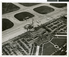
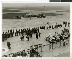
Photograph of the landing of Howard Hughes' Lockheed 14 aircraft, New York, July 14, 1938
Date
1938-07-14
Archival Collection
Description
The black and white, aerial view of Howard Hughes' Lockheed 14 aircraft performing its final landing on the Round the World flight at Floyd Bennett Airport, New York. Typed onto a piece of paper attached to the image: "Journey's End for World Fliers! Floyd Bennett Airport, N. Y. ---- The "World's Fair 1939.," Howard Hughes' silver monoplane, shown on the ground just after it landed here, concluding an amazing globe-girdling flight in total elapsed time of 3 days, 19 hours, 10 seconds. A crowd of officials surround the plane. Credit Line (ACME) 7/14/38."
Image
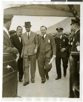
Photograph of Howard Hughes and Grover Whalen at Floyd Bennett Airfield, New York, July 14, 1938
Date
1938-07-14
Archival Collection
Description
A view of Howard Hughes being escorted by Grover Whalen and several guards at Floyd Bennett Airfield.
Image