Search Results
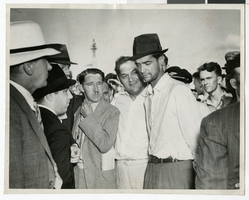
Photograph of Howard Hughes after arriving in Minneapolis, Minnesota, July 14, 1938
Date
1938-07-14
Archival Collection
Description
The black and white view of Howard Hughes in Minneapolis, Minnesota. Description written on back of photograph: "July 14, 1938: Tired and bearded, Howard Hughes was surrounded as he left his plane at the municipal airport (World-Chamberlain Field) to secure weather information before leaving Minneapolis to complete his record-breaking around-the-world flight-- the fastest flight ever made in circumnavigating the globe. Photo-courtesy "The Minneapolis Star" Board of Park Commissions 325 City Hall Minneapolis, Minn."
Image

Map of California, Utah, Nevada, Colorado, New Mexico and Arizona, 1864
Date
1864
Description
'Johnson's California, with Utah, Nevada, Colorado, New Mexico, and Arizona, published by Johnson and Ward.' 'Entered according to Act of Congress in the Year 1864 by A.J. Johnson in the Clerks Office of the District Court of the United States for the southern district of New York.' Atlas page numbers in upper margin: 66-67. This is probably plate 67 from Johnson's New Illustrated Family Atlas, published in New York by Johnson & Ward in 1864. Shows natural features, locations of Indian tribes, proposed railroad routes, routes of explorers, trails, county boundaries and populated places ; "." ; Relief shown by hachures ; Prime meridians: Greenwich and Washington ; In top margin: 66-67 ; Hand colored ; On verso: Historical and statistical view of Mexico and central America (p. 79) and Historical and statistical view of the United States, 1860 (p. 78) Scale [ca. 1:3,484,800]. 1 in. to ca. 55 miles (W 124°--W 102°/N 42°--N 32°)
Text
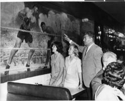
Photograph of two Las Vegas High School Rhythmettes and Jack Dempsey, New York City, June 1964
Date
1964-06
Archival Collection
Description
Two of the Las Vegas High School Rhythmettes with Jack Dempsey in his restaurant in New York City, New York.
Image
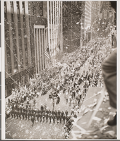
Photograph of a parade for Howard Hughes, Chicago, July 30, 1938
Date
1938-07-30
Archival Collection
Description
Description given on piece of paper attached to the image: "Chicago reception for Howard Hughes after completing his Round the World flight. Hughes is in the center of the car leading the parade."
Image
Howard Hawks director contracts and correspondence, 1931 July 14 to 1932 July 20
Level of Description
File
Archival Collection
Howard Hughes Film Production Records
To request this item in person:
Collection Number: MS-01036
Collection Name: Howard Hughes Film Production Records
Box/Folder: Box 516 (Restrictions apply)
Collection Name: Howard Hughes Film Production Records
Box/Folder: Box 516 (Restrictions apply)
Archival Component
Howard Hughes, Los Angeles, California Security Pacific tri-party agreement, 1985 July 01 to 1986 November 15
Level of Description
File
Archival Collection
Thomas L. Morgan Real Estate Development Records
To request this item in person:
Collection Number: MS-01091
Collection Name: Thomas L. Morgan Real Estate Development Records
Box/Folder: Box 02
Collection Name: Thomas L. Morgan Real Estate Development Records
Box/Folder: Box 02
Archival Component
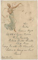
Hôtel Bristol menu, February 15, 1890
Date
1890-02-15
Archival Collection
Description
Note: Handwritten menu Restaurant: Hôtel Bristol
Text
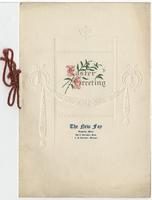
The New Fay Easter dinner menu, Sunday, April 7, 1912
Date
1912-04-07
Archival Collection
Description
Restaurant: The New Fay (Virginia, Minn.) Location: Virginia, Minnesota, United States
Text

Map of California, Utah, Nevada, Colorado, New Mexico and Arizona, 1864
Date
1864
Description
'Johnson's California, also Utah, Nevada, Colorado, New Mexico, and Arizona, published by A.J. Johnson, New York.' 'Entered according to Act of Congress in the Year 1864, by A.J. Johnson in the Clerks Office of the District Court of the United States for the Southern District of New York.' Atlas page numbers in upper margin: 66-67. Relief shown by hachures. Prime meridians: Greenwich and Washington, D.C. Shows proposed railroads, locations of Indian tribes, natural features, counties, mines, mail routes, trails and routes of exploring expeditions. On verso: History and statistics of Mexico and Central America and statistics of national finances and the Post Office of the United States, 1860. Scale [ca. 1:3,484,800. 1 in. to ca. 55 miles] (W 123°--W 103°/N 42°--N 32°)
Text
National City Bank of New York account transactions, 1932 April to 1933 February
Level of Description
File
Archival Collection
Howard Hughes Film Production Records
To request this item in person:
Collection Number: MS-01036
Collection Name: Howard Hughes Film Production Records
Box/Folder: Box 089 (Restrictions apply)
Collection Name: Howard Hughes Film Production Records
Box/Folder: Box 089 (Restrictions apply)
Archival Component