Search Results
T-Shirt Color: Navy Blue; Front: Always Honored Never Forgotten 09-11-01, Port Authority Police New York , New Jersey, Twin Towers, American Flag, Dept. Emblem; Back: Port Authority Police New York, New Jersey, (Several Names Listed), Dept. Emblem, approximately 2001-2012
Level of Description
File
Archival Collection
New York-New York Hotel and Casino 9-11 Heroes Tribute Collection
To request this item in person:
Collection Number: MS-00459
Collection Name: New York-New York Hotel and Casino 9-11 Heroes Tribute Collection
Box/Folder: Box 140
Collection Name: New York-New York Hotel and Casino 9-11 Heroes Tribute Collection
Box/Folder: Box 140
Archival Component
T-Shirt Color: Navy Blue; Front: Always Honored Never Forgotten 09-11-01, Port Authority Police New York New Jersey, Police Badge And Twin Towers; Back: Port Authority Police New York New Jersey, Numerous Names, Police Badge And Twin Towers, approximately 2001-2012
Level of Description
File
Archival Collection
New York-New York Hotel and Casino 9-11 Heroes Tribute Collection
To request this item in person:
Collection Number: MS-00459
Collection Name: New York-New York Hotel and Casino 9-11 Heroes Tribute Collection
Box/Folder: Box 37
Collection Name: New York-New York Hotel and Casino 9-11 Heroes Tribute Collection
Box/Folder: Box 37
Archival Component

Map of California, Utah, Nevada, Colorado, New Mexico and Arizona, circa 1867
Date
1865 to 1869
Description
39 x 56 cm. Relief shown by hachures. "Entered according to act of Congress in the year 1864, by A.J. Johnson in the Clerks Office of the United States for the Southern District of New York." Atlas page numbers in upper margin: 67-68. Primer meridians: Greenwich and Washington, D.C. On verso: History and statistical view of the West India islands or Columbian Archipelago and Historical and statistical view of Mexico and Central America. Shows proposed railroads, locations of Indian tribes, natural features, counties, mines, mail routes, trails and routes of exploring expeditions. Has decorative border. Southern part of Nevada was added to the state in 1867 and is part of Nevada on this map, but Lincoln County was established in 1867 and is not on this map. This map was still probably published in 1867 in spite of someone's having written "1864" in pencil in the lower right corner of the Library's copy. Original publisher: A.J. Johnson.
Image
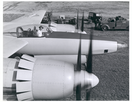
Photograph of Howard Hughes in cockpit of the XF-11, Culver City, California, July 7, 1946
Date
1946-07-07
Archival Collection
Description
Howard Hughes in the cockpit of the XF-11. Trucks and emergency vehicles are seen nearby.
Image

Photograph of Howard Hughes after arriving in Minneapolis, Minnesota, July 14, 1938
Date
1938-07-14
Archival Collection
Description
The black and white view of the Lockheed 14 aircraft in Minneapolis, Minnesota. Description written on back of photograph: "World-fame drops on City out of blue, sunny skies: Fame came to the municipal airport and the city of Minneapolis in a flash of silver and a roar at 7:38 am, July 14, 1938 when Howard Hughes swooped to Earth in his Droning Silver Bullet on his record breaking round-the-world flight. Photo-courtesy "The Minneapolis Star" Board of Park Commissions. 325 City Hall Minneapolis Minn."
Image
Photograph of Howard Hughes, Los Angeles, September 11, 1946
Date
1946-09-11
Archival Collection
Description
Description given with photo: "Before Hughes Took Off For New York, Los Angeles, Calif. - Multi-millionaire movie producer and aviator Howard Hughes is shown in front of this B-23 converted bomber before taking off for New York Sept. 10th. Hughes, piloting the plane, landed at Kansas City to rest before continuing with the flight. He is the seal of approval on a film he made. Creditline (ACME) 9/11/46."
Image
Powell's personal photographs taken on a trip from New York to the west coast, including desert landscape throughout the Southwest, Northern Nevada, and Lake Champlain in Essex, New York: photograph album, approximately 1910 to 1920
Level of Description
File
Archival Collection
Emily Higby Powell Photograph Album
To request this item in person:
Collection Number: PH-00114
Collection Name: Emily Higby Powell Photograph Album
Box/Folder: Oversized Box 01
Collection Name: Emily Higby Powell Photograph Album
Box/Folder: Oversized Box 01
Archival Component
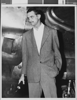
Howard Hughes after landing in New York after a high-altitude flight from Los Angeles during which he tested a new two-ounce oxygen mask; with him were Charles Perrine, Glenn Odekirk, and Harry Connor, 1938 August 20
Level of Description
File
Archival Collection
Howard Hughes Public Relations Photograph Collection
To request this item in person:
Collection Number: PH-00373
Collection Name: Howard Hughes Public Relations Photograph Collection
Box/Folder: Folder 17
Collection Name: Howard Hughes Public Relations Photograph Collection
Box/Folder: Folder 17
Archival Component