Search Results
Seinfeld, J. H., 1986, Atmospheric Chemistry and Physics of Air Pollution, pp. 26-31, John Wiley and Sons, Inc., New York, New York, 1986
Level of Description
File
Archival Collection
Environmental Radiation Protection Standards for Yucca Mountain, Nevada
To request this item in person:
Collection Number: MS-00603
Collection Name: Environmental Radiation Protection Standards for Yucca Mountain, Nevada
Box/Folder: Box 22
Collection Name: Environmental Radiation Protection Standards for Yucca Mountain, Nevada
Box/Folder: Box 22
Archival Component

Map of California and territories of New Mexico and Utah, circa 1861
Date
1859 to 1862
Description
'Compiled, drawn, and engraved under the supervision of J.H. Colton and A.J. Johnson.' Relief shown by hachures and spot heights. Scale [ca. 1:3,041,280]. 1 in. to approx. 48 miles (W 124°--W 103°/N 42°--N 31°). Hand colored
Prime meridians: Greenwich and Washington
Plates 54 & 55 removed from Johnson's New illustrated family atlas of the world, with descriptions geographical, statistical and historical ... New York, 1862
Title page of atlas.
Prime meridians: Greenwich and Washington
Plates 54 & 55 removed from Johnson's New illustrated family atlas of the world, with descriptions geographical, statistical and historical ... New York, 1862
Title page of atlas.
Image

Photograph of Howard Hughes and the Lockheed 14, July 3, 1938
Date
1938-07-03
Archival Collection
Description
Howard Hughes in the Lockheed 14. Typed on a piece of paper attached to the image: "Howard Hughes, lifting his plane and headed for Wichita, Kansas, on the first leg of his flight to Newark, N.J. from where he will hop-off for Paris."
Image
T-Shirt Color: Gray; Front: City Of New York Fire Dept. FDNY, Dept. Badge W/ New York City Sky Line, approximately 2001-2012
Level of Description
File
Archival Collection
New York-New York Hotel and Casino 9-11 Heroes Tribute Collection
To request this item in person:
Collection Number: MS-00459
Collection Name: New York-New York Hotel and Casino 9-11 Heroes Tribute Collection
Box/Folder: Box 357
Collection Name: New York-New York Hotel and Casino 9-11 Heroes Tribute Collection
Box/Folder: Box 357
Archival Component
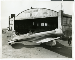
Photograph of Howard Hughes' Northrop Gamma Racer in Newark, New Jersey, January 14, 1936
Date
1936-01-04
Archival Collection
Description
A view of the side of Howard Hughes' Northrop Gamma Racer.
Image
Howard Hughes and co-pilot Joseph Bartles at the controls of their Lockheed Constellation after landing at LaGuardia Field in New York City, 1946 February 15
Level of Description
File
Archival Collection
Howard Hughes Public Relations Photograph Collection
To request this item in person:
Collection Number: PH-00373
Collection Name: Howard Hughes Public Relations Photograph Collection
Box/Folder: Folder 20
Collection Name: Howard Hughes Public Relations Photograph Collection
Box/Folder: Folder 20
Archival Component
Howard Hughes sitting inside of a B-23 converted bomber before taking off for New York City in Los Angeles, California, 1946 September 11
Level of Description
File
Archival Collection
Howard Hughes Public Relations Photograph Collection
To request this item in person:
Collection Number: PH-00373
Collection Name: Howard Hughes Public Relations Photograph Collection
Box/Folder: Folder 22
Collection Name: Howard Hughes Public Relations Photograph Collection
Box/Folder: Folder 22
Archival Component
Howard Hughes, Albert Lodwick, and an unidentified man at Floyd Bennett Field after record flight from Miami to New York, 1936 April 21
Level of Description
File
Archival Collection
Howard Hughes Public Relations Photograph Collection
To request this item in person:
Collection Number: PH-00373
Collection Name: Howard Hughes Public Relations Photograph Collection
Box/Folder: Folder 01
Collection Name: Howard Hughes Public Relations Photograph Collection
Box/Folder: Folder 01
Archival Component