Search Results
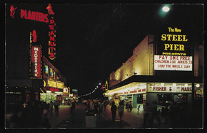
Nighttime view of Atlantic City, New Jersey: postcard
Date
1940 (year approximate) to 1990 (year approximate)
Archival Collection
Description
From Harvey's Hotel and Casino Postcard Collection (PH-00367)
Image

Photograph of the landing of Howard Hughes' Lockheed 14 aircraft, New York, July 14, 1938
Date
1938-07-14
Archival Collection
Description
The black and white, aerial view of Howard Hughes' Lockheed 14 aircraft preparing for its final landing on its Round the World flight in Floyd Bennett Field, New York.
Image

Photograph of the landing of Howard Hughes' Lockheed 14 aircraft, New York, July 14, 1938
Date
1938-07-14
Archival Collection
Description
The black and white, aerial view of Howard Hughes' Lockheed 14 aircraft after performing its final landing on the Round the World flight at Floyd Bennett Airport, New York.
Image

City map of Las Vegas, 1973
Date
1905-05-26
Description
Color; 55 x 45 cm., on sheet 95 x 47 cm., folded to 24 x 10 cm. Panel title: Las Vegas city map. Copyright held by Cardinal Publishing Company. Relief shown by hachures. Includes illustrations and advertisements. Index, text, illustrations, advertisements, and map of "Lake Mead National Recreation Area, lower basin section" on verso. Original publisher: Cardinal Publishing Company.
Image

Map of California and Territories of New Mexico and Utah, 1862
Date
1862
Description
Scale [ca. 1:3,231,360. 1 in. to approx. 51 miles] (W 125°00--W 103°30/N 42°00--N 31°45) ; 1 map : hand col. ; 40 x 60 cm., on sheet 46 x 68 cm ; Relief indicated by hachures and spot heights ; Prime meridians: Greenwich and Washington, D.C ; Decorative border ; Hand colored ; Atlas p. numbers in upper margin: 58-59 ; Date est. from territorial borders and county configuration ; Shows natural features, locations of Indian tribes, proposed railroad routes, routes of explorers, trails, county boundaries and populated places ; Johnson and Ward
Image

Trinity Church and lower Manhattan from Financial District, New York City, New York: panoramic photograph
Date
1981-05-24
Archival Collection
Description
From the Bob Paluzzi Panoramic Photographs
Image
Vassili Sulich and dance partner, New York City, New York, approximately 1960-1969
Level of Description
File
Archival Collection
Vassili Sulich Photographs
To request this item in person:
Collection Number: PH-00353
Collection Name: Vassili Sulich Photographs
Box/Folder: Folder 13
Collection Name: Vassili Sulich Photographs
Box/Folder: Folder 13
Archival Component
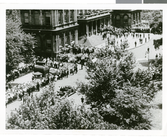
Photographs of crowds at Around-the-World-Flight Parade, New York City (N.Y.), July 15, 1938
Date
1938-07-15
Archival Collection
Description
Crowd at a parade in New York City celebrating the completion of Howard Hughes' Around-the-World Flight!
Image

Photograph of the landing of Howard Hughes' Lockheed 14 aircraft, New York, July 14, 1938
Date
1938-07-14
Archival Collection
Description
The black and white, aerial view of Howard Hughes' Lockheed 14 aircraft after performing its final landing on the Round the World flight at Floyd Bennett Airport, New York. Typed onto a piece of paper attached to the image: "Crowd greeting Howard Hughes and crew at floyd Bennett Airport after completing Round-the-World flight."
Image
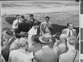
Photograph of Howard Hughes installing radar, Culver City, California, May 03, 1947
Date
1947-05-03
Archival Collection
Description
A view of Howard Hughes conversing with an unidentified group of people in Calfornia.
Image