Search Results
Howard Hughes leaves Newark, New Jersey Airport with party en route to Washington, D.C., 1938 July 21
Level of Description
File
Archival Collection
Howard Hughes Public Relations Photograph Collection
To request this item in person:
Collection Number: PH-00373
Collection Name: Howard Hughes Public Relations Photograph Collection
Box/Folder: Folder 13
Collection Name: Howard Hughes Public Relations Photograph Collection
Box/Folder: Folder 13
Archival Component
Howard Hughes, Tom Thurlow, Harry Connor, Richard Stoddart, and Dale Powers in New York, 1938 July 04
Level of Description
File
Archival Collection
Howard Hughes Public Relations Photograph Collection
To request this item in person:
Collection Number: PH-00373
Collection Name: Howard Hughes Public Relations Photograph Collection
Box/Folder: Folder 05
Collection Name: Howard Hughes Public Relations Photograph Collection
Box/Folder: Folder 05
Archival Component
Howard Hughes at the controls of plane before leaving Glendale, California, on a nonstop flight to New York, 1938 August 20
Level of Description
File
Archival Collection
Howard Hughes Public Relations Photograph Collection
To request this item in person:
Collection Number: PH-00373
Collection Name: Howard Hughes Public Relations Photograph Collection
Box/Folder: Folder 17
Collection Name: Howard Hughes Public Relations Photograph Collection
Box/Folder: Folder 17
Archival Component
Howard Cannon visits the new Savage Mine at Virginia City, Nevada: photographic print and photographic negative, 1981 January
Level of Description
Item
Archival Collection
Howard Cannon Photograph Collection
To request this item in person:
Collection Number: PH-00192
Collection Name: Howard Cannon Photograph Collection
Box/Folder: Folder 18, Box SH-026
Collection Name: Howard Cannon Photograph Collection
Box/Folder: Folder 18, Box SH-026
Archival Component

Geologic map of the northeast quarter of the Bullfrog 15-minute quadrangle, Nye County, Nevada, 1990
Date
1990
Description
58 x 46 cm., on sheet 87 x 102 cm., folded in envelope 30 x 24 cm. Relief shown by contours and spot heights. "Contour interval 40 feet." "Base from U.S. Geological Survey 1:62,500. 1954." "Geology mapped in 1985 and 1988." Includes text, bibliography, 4 col. cross sections, and location and index maps. "Prepared in cooperation with the U. S. Atomic Commission." Original publisher: U. S. Geological Survey, Series: Miscellaneous investigations series, map I, Scale: 1:24 000.
Image
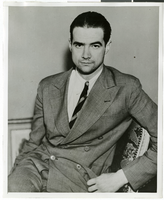
Photograph of Howard Hughes, 1936
Date
1936-01
Archival Collection
Description
A portrait of Howard Hughes.
Image
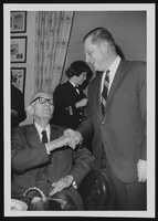
Howard Cannon with a man in a wheelchair: photographic print
Date
1970-12-09
Archival Collection
Description
From the Howard Cannon Photograph Collection (PH-00192)
Image

Map showing U.S. Bureau of Reclamation Region 3 projects in Arizona, California, Nevada, New Mexico and Utah, September 1967
Date
1967-09
Description
'United States, Department of the Interior, Stewart L. Udall, Secretary. Bureau of Reclamation, Floyd E. Dominy, Commissioner.' 'Map. No. X-300-738. September 1967.' Scale [ca. 1:1,774,080] (W 119°--W 108°/N 39°--N 32°). Relief shown pictorially. Shows completed, under construction and proposed dams and reservoirs, canals, and aqueducts, power plants, pumping plants, substations, transmission lines, tunnels and siphons. Also shows non-Bureau of Reclamation dams, reservoirs, tunnels, pipelines and irrigated lands. Includes inset map of location of Region 3 and key map of drainage basins. Bureau of Reclamation, [Region 3?].
Image

Hotel Construction: Monte Carlo, New York-New York, and Stratosphere, Culinary Union, Las Vegas (Nev.), 1996 June (folder 1 of 1), image 15
Date
1996-06
Description
Arrangement note: Series III. Internal: Work
Image
Hong Kong Tourist Association's Lunar New Year Dinner, menu, 1996 February 15
Level of Description
File
Archival Collection
UNLV University Libraries Menu Collection
To request this item in person:
Collection Number: MS-00436
Collection Name: UNLV University Libraries Menu Collection
Box/Folder: Box 56
Collection Name: UNLV University Libraries Menu Collection
Box/Folder: Box 56
Archival Component