Search Results
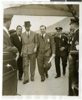
Photograph of Howard Hughes and Grover Whalen at Floyd Bennett Airfield, New York, July 14, 1938
Date
1938-07-14
Archival Collection
Description
A view of Howard Hughes being escorted by Grover Whalen and several guards at Floyd Bennett Airfield.
Image
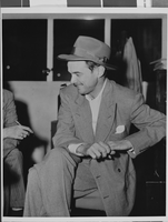
Photograph of Howard Hughes after hearing, Culver City, California, August 15, 1947
Date
1947-08-15
Archival Collection
Description
A view of Howard Hughes attending an informal press conference in Culver City, California, after Hughes left the Senate War Investigating Subcommittee hearing in Washington.
Image
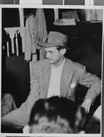
Photograph of Howard Hughes after hearing, Culver City, California, August 15, 1947
Date
1947-08-15
Archival Collection
Description
A view of Howard Hughes attending an informal press conference in Culver City, California, after Hughes left the Senate War Investigating Subcommittee hearing in Washington.
Image
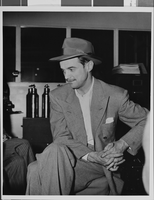
Photograph of Howard Hughes after hearing, Culver City, California, August 15, 1947
Date
1947-08-15
Archival Collection
Description
A view of Howard Hughes attending an informal press conference in Culver City, California, after Hughes left the Senate War Investigating Subcommittee hearing in Washington.
Image

Photograph of a crowd of people awaiting the arrival of Howard Hughes, New York, July 14, 1938
Date
1938-07-14
Archival Collection
Description
The black and white view of members of the Aeronautical Association awaiting the arrival of Howard Hughes and his Lockheed 12 aircraft at the Floyd Bennett Airport in New York. Typed onto a piece of paper attached to the image: "Official timers of Aeronautical Association compare their precision chronometers as Lockheed-14 roars overhead, marking end of Round-the-World flight at Floyd Bennett Airport." Typed onto a second piece of paper also attached to the image: "Official timers of the Aeronautical Association shown at Floyd Bennett Field comparing their precision chronometers as Howard Hughes' plane roared overhead marking the end of his Flight Around The World. July 1938."
Image

Map of California, Utah, Nevada, Colorado, New Mexico and Arizona, 1864
Date
1864
Description
'Johnson's California, also Utah, Nevada, Colorado, New Mexico, and Arizona, published by A.J. Johnson, New York.' 'Entered according to Act of Congress in the Year 1864, by A.J. Johnson in the Clerks Office of the District Court of the United States for the Southern District of New York.' Atlas page numbers in upper margin: 66-67. Relief shown by hachures. Prime meridians: Greenwich and Washington, D.C. Shows proposed railroads, locations of Indian tribes, natural features, counties, mines, mail routes, trails and routes of exploring expeditions. On verso: History and statistics of Mexico and Central America and statistics of national finances and the Post Office of the United States, 1860. Scale [ca. 1:3,484,800. 1 in. to ca. 55 miles] (W 123°--W 103°/N 42°--N 32°)
Text
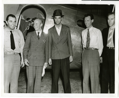
Photograph of Howard Hughes, Tom Thurlow, Harry Connor, Richard Staddart, and Dale Powers, New York, July 4, 1938
Date
1938-07-04
Archival Collection
Description
Howard Hughes, Tom Thurlow, Harry Connor, Richard Staddart, and Dale Powers with an unidentified aircraft behind them in New York. Typed on a piece of paper attached to the image: "Hughes flies to New York for hop to Paris. L to R L. Tom Thurlow and Harry Connor, Hughes, Richard Stoddart and Dale Powers. 7/4/1938."
Image
Photograph of Howard Hughes after hearing, Culver City, California, August 15, 1947
Date
1947-08-15
Archival Collection
Description
A view of Howard Hughes attending an informal press conference in Culver City, California, after Hughes left the Senate War Investigating Subcommittee hearing in Washington.
Image

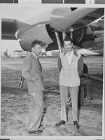
Photograph of Howard Hughes and the Lockheed 14 aircraft, Fairbanks, Alaska, July 15, 1938
Date
1938-07-15
Archival Collection
Description
The black and white view of Howard Hughes walking with other unidentified men toward the Lockheed 14 aircraft that was then being refueled. Hughes was then on his Around the World Flight where he visited Paris, Moscow, Fairbanks, and Alaska.
Image
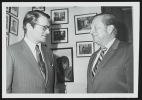
Elliott Richardson, new ambassador to Britain meets with Howard Cannon in his Washington, D.C. office: photographic print
Date
1950 (year approximate) to 1983 (year approximate)
Archival Collection
Description
From the Howard Cannon Photograph Collection (PH-00192)
Image