Search the Special Collections and Archives Portal
Search Results
Howard Hughes at Floyd Bennett Airfield, New York, 1938 July 14
Level of Description
File
Archival Collection
Howard Hughes Public Relations Photograph Collection
To request this item in person:
Collection Number: PH-00373
Collection Name: Howard Hughes Public Relations Photograph Collection
Box/Folder: Folder 09
Collection Name: Howard Hughes Public Relations Photograph Collection
Box/Folder: Folder 09
Archival Component

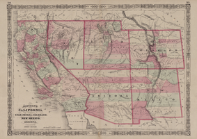
Map of California, with territories of Utah, Nevada, Colorado, New Mexico, and Arizona, 1864
Date
1864
Description
40 x 62 cm. Relief shown by hachures. Prime meridians: Greenwich and Washington. Page numbers at top: 58-59. "Entered according to act of Congress in the year 1864 by A. J. Johnson in the Clerk's Office of the District Court of the United States for the Southern District of New York." Original publisher: Johnson and Ward.
Image

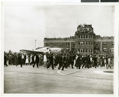
Photograph of the landing of Howard Hughes' Lockheed 14 aircraft, New York, July 14, 1938
Date
1938-07-14
Archival Collection
Description
The black and white view of Howard Hughes' Lockheed 14 aircraft performing its final landing on the Round the World flight at Floyd Bennett Airport, New York. Typed onto a piece of paper attached to the image: "Howard Hughes two-motored monoplane is shown here being taken past the administration building at Floyd Bennett Airport after Hughes completed a round the world trip. 7-14-38. (Press Association)."
Image
Howard Hughes at Floyd Bennett Field, New York, 1938 July 09
Level of Description
File
Archival Collection
Howard Hughes Public Relations Photograph Collection
To request this item in person:
Collection Number: PH-00373
Collection Name: Howard Hughes Public Relations Photograph Collection
Box/Folder: Folder 05
Collection Name: Howard Hughes Public Relations Photograph Collection
Box/Folder: Folder 05
Archival Component

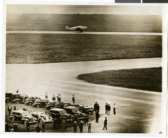
Photograph of the landing of Howard Hughes' Lockheed 14 aircraft, New York, July 14, 1938
Date
1938-07-14
Archival Collection
Description
The black and white, aerial view of Howard Hughes' Lockheed 14 aircraft performing its final landing on the Round the World flight at Floyd Bennett Airport, New York. Typed onto a piece of paper attached to the image: "Howard Hughes big silver monoplane landing at Floyd Bennett Field his afternoon completing a record flight around the world in 3 days, 13 hours, and 17 minutes. 7/14/38 (Press Association)."
Image
Pagination
Refine my results
Content Type
Creator or Contributor
Subject
Archival Collection
Digital Project
Resource Type
Year
Material Type
Place
Language
Records Classification
