Search Results
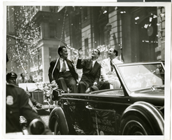
Photograph of a parade procession for Howard Hughes, New York, July 15, 1938
Date
1938-07-15
Archival Collection
Description
A view of Grover Whalen, Howard Hughes, and Al Lodwick riding in the back of an automobile during a parade procession.
Image
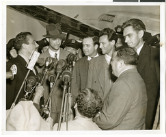
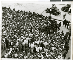
Photograph of Howard Hughes at Floyd Bennett Airfield, New York, July 14, 1938
Date
1938-07-14
Archival Collection
Description
The black and white view of Howard Hughes and his crew being surrounded by crowds as they exit the Lockheed 14 aircraft after finishing the Around the World flight at Floyd Bennett Airfield in New York. Description printed on photograph's accompanying sheet of paper: "Howard Hughes (with hat) as he arrived in New York after completing a round the world flight is shown with Grover Whalen (left) members of his crew and Mayor La Guardia (right front) 7-14-38 (Press Association)."
Image
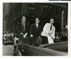
Photograph of a parade procession for Howard Hughes, New York, July 15, 1938
Date
1938-07-15
Archival Collection
Description
Photograph of Grover Whalen, Howard Hughes, and Al Lodwick during a parade procession for the completion of Hughes' Round-the-World flight.
Image
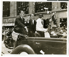
Photograph of a parade procession for Howard Hughes, New York, July 15, 1938
Date
1938-07-15
Archival Collection
Description
Photograph of Grover Whalen, Howard Hughes, and Al Lodwick during a parade procession for the completion of Hughes' Round-the-World flight.
Image
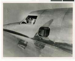
Photograph of Howard Hughes in the cockpit of a Lockheed-14 plane, New York, July 10, 1938
Date
1938-07-10
Archival Collection
Description
Howard Hughes in cockpit of Lockheed-14 before take-off from Floyd Bennet Field in New York.
Image
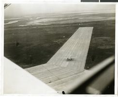
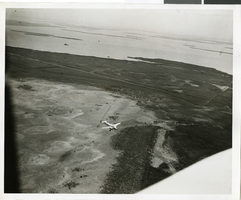
Photograph of the landing of Howard Hughes' Lockheed 14 aircraft, New York, July 14, 1938
Date
1938-07-14
Archival Collection
Description
The black and white, aerial view of Howard Hughes' Lockheed 14 aircraft performing its final landing on the Round the World flight at Floyd Bennett Airport, New York.
Image
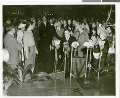
Photograph of Howard Hughes arriving at City Hall, New York City, July 15, 1938
Date
1938-07-15
Archival Collection
Description
Typed onto a piece of paper attached to the image: "New York welcoming Howard Hughes - close-up inside City Hall. 7/15/38."
Image
Photograph of the landing of Howard Hughes' Lockheed 14 aircraft, New York, July 14, 1938
Date
1938-07-14
Archival Collection
Description
The black and white, aerial view of Howard Hughes' Lockheed 14 aircraft performing its final landing on the Round the World flight in Floyd Bennett Airport, New York. Typed onto a piece of paper attached to the image: "Howard Hughes ready to land at Floyd Bennett Airport."
Image
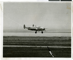
Photograph of the landing of Howard Hughes' Lockheed 14 aircraft, New York, July 14, 1938
Date
1938-07-14
Archival Collection
Description
The black and white, aerial view of Howard Hughes' Lockheed 14 aircraft preparing for its final landing on its Round the World flight in Floyd Bennett Field, New York. Typed onto a piece of paper attached to the image: "Aerial New of landing, 7-14-38. (Daily News.)" Typed onto a second piece of paper attached to the image: "Howard Hughes plane from a welcoming plane as the Round the World flight ended at Floyd Bennett Field."
Image
Photograph of the landing of Howard Hughes' Lockheed 14 aircraft, New York, July 14, 1938
Date
1938-07-14
Archival Collection
Description
The black and white view of a crowd of people watching Howard Hughes' Lockheed 14 aircraft performing its final landing on the Round the World flight at Floyd Bennett Airport, New York.
Image