Search Results

Photograph of the Lockheed 14 aircraft, July 10, 1938
Date
1938-07-10
Archival Collection
Description
The black and white view of the Lockheed 14 aircraft. Typed onto a piece of paper attached to the image: "Take-off from Floyd Bennett Airport for Paris on first lef of Round the World flight at 7:20 P.M. E.D.T. piloted by Howard Hughes with crew of four."
Image

Map of California, territories of New Mexico, Arizona, Colorado, Nevada and Utah, circa 1863
Date
1861 to 1865
Description
40 x 62 cm. Relief shown by hachures and spot heights. Prime meridians: Greenwich and Washington. "Historical and statistical view of the United States, 1860"--Verso. Atlas page numbers at top: 58-59. Arizona became a territory in 1863, and Nevada became a state on October 31, 1864, so this map was either published in 1863 or in 1864 before the end of October. Original publisher: Johnson and Ward.
Image
One of the two 34-ton wing sections of Howard Hughes's HK-1 Hercules is put on house-moving dollies in Culver City, California, before beginning the 28-mile journey to Los Angeles Harbor, 1946 June 12
Level of Description
File
Archival Collection
Howard Hughes Public Relations Photograph Collection
To request this item in person:
Collection Number: PH-00373
Collection Name: Howard Hughes Public Relations Photograph Collection
Box/Folder: Folder 20
Collection Name: Howard Hughes Public Relations Photograph Collection
Box/Folder: Folder 20
Archival Component
The Partridge Club of New York, Inc. opening luncheon, JW Marriott Essex House, New York City, New York: photographic print, 1946 October 07
Level of Description
Item
Archival Collection
International Food Service Executives Association Photograph Collection
To request this item in person:
Collection Number: PH-00363
Collection Name: International Food Service Executives Association Photograph Collection
Box/Folder: Oversized Box SH-068
Collection Name: International Food Service Executives Association Photograph Collection
Box/Folder: Oversized Box SH-068
Archival Component
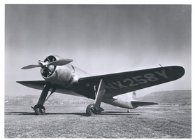
Photograph of Hughes H-1 Racer, November 1, 1945
Date
1945-11-01
Archival Collection
Description
The Hughes H-1 Racer, with its registration number NX 258Y on the underside of the port wing.
Image
Hughes's streamlined Stratoliner for another record-breaking transcontinental flight from Glendale, California, to New York, 1939 August 30
Level of Description
File
Archival Collection
Howard Hughes Public Relations Photograph Collection
To request this item in person:
Collection Number: PH-00373
Collection Name: Howard Hughes Public Relations Photograph Collection
Box/Folder: Folder 18
Collection Name: Howard Hughes Public Relations Photograph Collection
Box/Folder: Folder 18
Archival Component
Howard Hughes and Noah Dietrich, vice president of the Hughes Tool Company, look over their files and statements as the Senate War Investigating Subcommittee's hearing got under way, 1947 August 08
Level of Description
File
Archival Collection
Howard Hughes Public Relations Photograph Collection
To request this item in person:
Collection Number: PH-00373
Collection Name: Howard Hughes Public Relations Photograph Collection
Box/Folder: Folder 25
Collection Name: Howard Hughes Public Relations Photograph Collection
Box/Folder: Folder 25
Archival Component
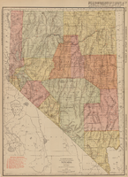
Rand-McNally new commercial atlas map of Nevada, 1912
Date
1912
Description
Original publisher: Rand, McNally & Co. Scale [ca. 1:1,203,840). 1 inch to 19 miles. Originally published as p. 316-317 of Rand McNally's commercial atlas of America. Title in right margin: Nevada : commercial atlas of America. Includes township and range grid. Includes index to Nevada railroads and index to principal cities with their populations. Index on verso to counties, towns and natural features in Oregon and Nevada.
Image
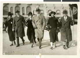
Photograph of Fleming and Ida Hubbard at J. C. Penney convention, Atlantic City, New Jersey, circa early 1900s
Date
1900 to 1939
Archival Collection
Description
Fleming Ballew Hubbard and Ida Mae Conklin Hubbard, far left, with others at a J. C. Penney convention on the boardwalk in Atlantic City, New Jersey.
Image