Search Results

neo000139-003
Description
Sign animation: Chasing, flashing, oscillating
Notes: the letters inside of the letters of the tower actually oscillate.
Notes: the letters inside of the letters of the tower actually oscillate.


Meeting minutes for Consolidated Student Senate, University of Nevada, Las Vegas, October 12, 1982
Date
1982-10-12
Archival Collection
Description
Includes meeting agenda and minutes. CSUN Session 12 Meeting Minutes and Agendas.
Text
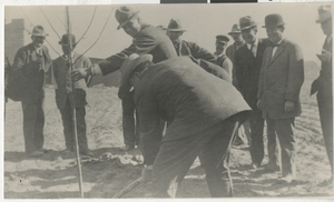
Photograph of people planting first tree in the courthouse park, Las Vegas in March 1911
Date
1911-03
Archival Collection
Description
Black and white photo taken by C. P. Squires on the occasion of planting the first tree in the courthouse park, Las Vegas, Nevada. Date, March 1911, as near as can be fixed. The building shown at left is the first Clark County Court House (now used for Las Vegas City Library) which had been constructed by popular subscription by Las Vegas Business men as promised by them during the county division campaign in 1908-1909. This building provided sufficient quarters for the county offices for five years, following which, the present court house was built. Persons shown, so far as their identity can be remembered are: holding the tree- Ed W. Clark and using the shovel is Judge E. J. L Taber. Others, left to right: Charlie Ronnow, Judge W. R. Thomas, unidentified, unidentified, Bob Dillon, Frank A. Stevens, Harley A. Harmon, and Dr. Roy W. Martin.
Image

Topographic map of groundwater in the southwest quadrangle of Las Vegas, Nevada, 1985
Date
1985
Description
'Las Vegas Area Map 3Bf.' 'Prepared in cooperation with the U.S. Geological Survey.' ' Water Resources Division, U.S. Geological Survey, Carson City, Nevada.' Scale 1:24,000 (W 115°15´00?--W 115°07´30? / N 36°07´30?--N 36°00´00?). Series: Las Vegas area map ; 3Bf. Urban area maps. Las Vegas area map ; 3Bf. Relief shown by contour lines and spot heights. Title in right and left margins: Las Vegas SW quad : ground water. Title on publications list on Nevada Bureau of Mines and Geology website: Groundwater map of the Las Vegas SW quadrangle. Series: Urban area maps [Las Vegas area map] from list of publications on Nevada Bureau of Mines and Geology website. Nevada Bureau of Mines and Geology
Text