Search Results
Howard R. Hughes College of Engineering: architectural plans, 1987 June 12
Level of Description
File
Archival Collection
J. A. Tiberti Construction Records
To request this item in person:
Collection Number: MS-00855
Collection Name: J. A. Tiberti Construction Records
Box/Folder: Roll 221
Collection Name: J. A. Tiberti Construction Records
Box/Folder: Roll 221
Archival Component
Howard R. Hughes College of Engineering: architectural plans, 1987 June 12
Level of Description
File
Archival Collection
J. A. Tiberti Construction Records
To request this item in person:
Collection Number: MS-00855
Collection Name: J. A. Tiberti Construction Records
Box/Folder: Roll 222
Collection Name: J. A. Tiberti Construction Records
Box/Folder: Roll 222
Archival Component
Howard Hughes Properties, Incorporated bankers meeting, 1986 January 14
Level of Description
File
Archival Collection
Thomas L. Morgan Real Estate Development Records
To request this item in person:
Collection Number: MS-01091
Collection Name: Thomas L. Morgan Real Estate Development Records
Box/Folder: Box 42
Collection Name: Thomas L. Morgan Real Estate Development Records
Box/Folder: Box 42
Archival Component
Thomas, Rich. The Real Howard Hughes?, Newsweek, 1972 April 10
Level of Description
File
Archival Collection
UNLV Libraries Collection of Articles on Gaming and Las Vegas, Nevada Topics
To request this item in person:
Collection Number: MS-00626
Collection Name: UNLV Libraries Collection of Articles on Gaming and Las Vegas, Nevada Topics
Box/Folder: Box 12
Collection Name: UNLV Libraries Collection of Articles on Gaming and Las Vegas, Nevada Topics
Box/Folder: Box 12
Archival Component
Howard Hughes signed contracts for Hell's Angels advertising, General Outdoor Advertising Company, includes description and examples of work, approximately 1930 July
Level of Description
File
Archival Collection
Howard Hughes Film Production Records
To request this item in person:
Collection Number: MS-01036
Collection Name: Howard Hughes Film Production Records
Box/Folder: Box 025 (Restrictions apply)
Collection Name: Howard Hughes Film Production Records
Box/Folder: Box 025 (Restrictions apply)
Archival Component
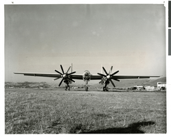
Photograph of the first XF-11 plane at the Hughes Airport, Culver City, California, July 3, 1947
Date
1946-07-03
Archival Collection
Description
The XF-11 plane before its first flight at the Hughes Airport in Culver City, California.
Image
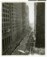
Photograph of a parade procession, New York, July 15, 1938
Date
1938-07-15
Archival Collection
Description
An overhead view of people looking up and waving during a parade procession.
Image
Camera logs for directors' Jules Furthman, Howard Hawks, and Howard Hughes, 1940 December 03 to 1948 September 10
Level of Description
File
Archival Collection
Howard Hughes Film Production Records
To request this item in person:
Collection Number: MS-01036
Collection Name: Howard Hughes Film Production Records
Box/Folder: Box 148 (Restrictions apply)
Collection Name: Howard Hughes Film Production Records
Box/Folder: Box 148 (Restrictions apply)
Archival Component
Howard Hughes speaking to Senators J. Howard McGrath, Claud Pepper, Homer Ferguson, and John J. Williams, 1947 August 08
Level of Description
File
Archival Collection
Howard Hughes Public Relations Photograph Collection
To request this item in person:
Collection Number: PH-00373
Collection Name: Howard Hughes Public Relations Photograph Collection
Box/Folder: Folder 26
Collection Name: Howard Hughes Public Relations Photograph Collection
Box/Folder: Folder 26
Archival Component
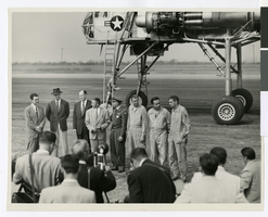
Photograph of Howard Hughes and others in front of the XH-17 helicopter, Culver City, California, October 23, 1952
Date
1952
Archival Collection
Description
Howard Hughes (second from left) standing in front of the experimental helicopter XH-17, Flying Crane, with others (from left to right): Rea Hopper, Director of the Aeronautical Division, Hughes Aircraft Company; Hughes; Clyde Jones, Director of Engineering, Hughes Tool Company Aeronautical Division; Warren Reed, Assistant; Colonel Carl E. Jackson from Air Research and Development Headquarters, Baltimore; Gale J. Moore, Pilot; possibly Chal Bowen, Flight Engineer/Co-pilot; and an unidentified man, October 23, 1952.
Image