Search Results

Map of California and territories of New Mexico and Utah, circa 1861
Date
1859 to 1862
Description
'Compiled, drawn, and engraved under the supervision of J.H. Colton and A.J. Johnson.' Relief shown by hachures and spot heights. Scale [ca. 1:3,041,280]. 1 in. to approx. 48 miles (W 124°--W 103°/N 42°--N 31°). Hand colored
Prime meridians: Greenwich and Washington
Plates 54 & 55 removed from Johnson's New illustrated family atlas of the world, with descriptions geographical, statistical and historical ... New York, 1862
Title page of atlas.
Prime meridians: Greenwich and Washington
Plates 54 & 55 removed from Johnson's New illustrated family atlas of the world, with descriptions geographical, statistical and historical ... New York, 1862
Title page of atlas.
Image

Las Vegas City Ordinances, July 18, 1911 to March 31, 1933
Date
1911-07-18 to 1933-03-31
Archival Collection
Description
Bound volume of Las Vegas City Ordinances, July 18, 1911 to March 31, 1933
Text
Howard Hughes after his around-the-world flight shaking hands with Secretary of State Cordell Hull as R. Walton Moore, Counselor of the Department of State, looks on, 1938 July 21
Level of Description
File
Archival Collection
Howard Hughes Public Relations Photograph Collection
To request this item in person:
Collection Number: PH-00373
Collection Name: Howard Hughes Public Relations Photograph Collection
Box/Folder: Folder 13
Collection Name: Howard Hughes Public Relations Photograph Collection
Box/Folder: Folder 13
Archival Component
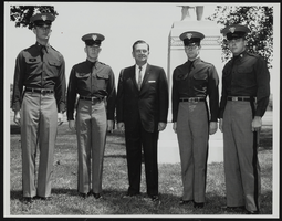
Howard Cannon visits West Point, New York with four unidentified cadets: photographic print
Date
1970-10-08
Archival Collection
Description
From the Howard Cannon Photograph Collection (PH-00192). Stamped on verso: "Signal Division File #USMA-64-1996 NR West Point New York 25 May 64 - Photo by Mr Murphy". Stamped on verso: "Please give credit as 'U.S. Army Photograph'"
Image
New Frontier images and videos, 2007 June-July
Level of Description
File
Archival Collection
Barbara Tabach Collection on the New Frontier Hotel and Casino, Las Vegas
To request this item in person:
Collection Number: MS-00800
Collection Name: Barbara Tabach Collection on the New Frontier Hotel and Casino, Las Vegas
Box/Folder: Digital File 00
Collection Name: Barbara Tabach Collection on the New Frontier Hotel and Casino, Las Vegas
Box/Folder: Digital File 00
Archival Component
Howard Hughes makes his first appearance before the press since the start of the U.S. Senate investigation into his multi-million dollar plane contracts, 1947 July 30
Level of Description
File
Archival Collection
Howard Hughes Public Relations Photograph Collection
To request this item in person:
Collection Number: PH-00373
Collection Name: Howard Hughes Public Relations Photograph Collection
Box/Folder: Folder 24
Collection Name: Howard Hughes Public Relations Photograph Collection
Box/Folder: Folder 24
Archival Component
Roy Pomeroy option agreement with Hughes Development Company for Multicolor equipment, 1931 July 16 to 1931 July 21
Level of Description
File
Archival Collection
Howard Hughes Film Production Records
To request this item in person:
Collection Number: MS-01036
Collection Name: Howard Hughes Film Production Records
Box/Folder: Box 516 (Restrictions apply)
Collection Name: Howard Hughes Film Production Records
Box/Folder: Box 516 (Restrictions apply)
Archival Component

Photograph of the Lockheed 14 aircraft at Floyd Bennett Field, New York, July 10, 1938
Date
1938-07-10
Archival Collection
Description
The black and white view of the Lockheed 14 aircraft being surrounded by people at Floyd Bennett Field in New York.
Image
Committee to Save the Hughes Flying Boat newspaper clippings, 1980 July
Level of Description
File
Archival Collection
Bob McCaffery Collection on the Save the Hughes Flying Boat Campaign
To request this item in person:
Collection Number: MS-00693
Collection Name: Bob McCaffery Collection on the Save the Hughes Flying Boat Campaign
Box/Folder: Box 01
Collection Name: Bob McCaffery Collection on the Save the Hughes Flying Boat Campaign
Box/Folder: Box 01
Archival Component
Anthony Fokker and Howard Hughes, Hell's Angels: photographic print, 1928
Level of Description
Item
Archival Collection
Howard Hughes Film Production Records
To request this item in person:
Collection Number: MS-01036
Collection Name: Howard Hughes Film Production Records
Box/Folder: Box 025 (Restrictions apply)
Collection Name: Howard Hughes Film Production Records
Box/Folder: Box 025 (Restrictions apply)
Archival Component