
Search the Special Collections and Archives Portal

Search Results

Display    Results Per Page
Displaying results 109961 - 109970 of 114301

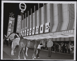
Photograph of horses and a crowd outside of the Horseshoe Casino, Las Vegas (Nev.), April 17, 1968

Date

1968-04-17

Description

Unidentified people stand with horses on the street outside of the Horseshoe Casino on April 17, 1968 while spectators on the sidewalk watch. Inscription with the image reads: "Quarter horse sale, Fremont Street." The stamp on back of photo says, "Allen Photographers. Inc. Post Office box 4253 Las Vegas, Nevada 89106." For other images of the same event, see pho026119 & pho026120.

Image

U-Wah-Un Study Club Records

Identifier

MS-00198

Abstract

U-Wah-Un Study Club Records (1919-1987) include a complete set of the organization's yearbooks from 1919 to 1977, a club scrapbook, meeting minutes, and financial records.

Archival Collection

UNLV Libraries Collection of American Advertising Federation ADDY Award Submissions

Identifier

MS-01023

Abstract

The UNLV Libraries Collection of American Advertising Federation: ADDY Award Submissions Collection is compromised of Las Vegas, Nevada ADDY award submissions dating from approximately 1980 to 1999. The collection contains submissions by many artists to the ADDYS competition.

Archival Collection

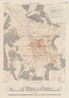
Map and basin profiles showing thickness of valley-fill deposits, Las Vegas Valley, Nevada, 1981 (color variation)

Date

1981

Description

At top of map: 'Department of the Interior. U.S. Geological Survey. Water supply paper2320-A, plate 5.' 'Prepared in cooperation with the Clark County Department of Comprehensive Planning.' At bottom of map: 'Base from U.S. Geological Survey, 1:100,000, Boulder City, Ariz.-Nev., Las Vegas, Nev.-Calif., Mesquite Lake, Nev.-Calif., 1978; Lake Mead, Nev.-Ariz., 1979.' 'Geology from Malmberg (1965); Longwell and others (1965); Haynes (1967); Bell and Smith (1980); Bell (1981) and J. R. Harrill, 1976. Thickness of valley-fill deposits by R.W. Plume, 1981.' Includes three profiles. Shows township and range lines. Scale 1:100.000 (W 115°30´--W 115°00´/N 36°30´--N 36°00´). Series: U.S. Geological Survey water-supply paper, 2320-A. Originally published as plate 5 of Ground-water conditions in Las Vegas Valley, Clark County, Nevada. Part I. Hydrogeologic framework / by Russell W. Plume, published by the U.S. Geological Survey in 1989 as Water-supply paper 2320-A.

Image

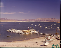
Film transparency of Las Vegas Bay, Lake Mead, Nevada, 1961

Date

1961

Description

Boats are moored at the marina, as well as offshore. Some boats are on the beach, waiting to launch. A few small islands are visible in the background. Las Vegas Bay is a bay at the western edge of Lake Mead, to the northeast of the city of Henderson, Nevada, near the junction of Lake Mead Drive and Lake Mead Boulevard. A public campground and boat access are available in Las Vegas Bay. Low water levels of Lake Mead have rendered the marina there inoperable, and it relocated to the Hemenway Boat Harbor, in the south end of the Boulder Basin in 2002. The launch ramp there has also been closed due to the water levels. The Lake Mead Marina was relocated to the Hemenway Boat Harbor in 2008. The bay is the natural discharge point for the Las Vegas Wash. Las Vegas Wash is in the southeastern portion of the Las Vegas Valley and is approximately 12 miles long, from its headwaters northwest of Las Vegas to its mouth at Las Vegas Bay on the western portion of Lake Mead. The bridge across the Wash on Northshore Road is approximately 1.2 miles north of the intersection of Lakeshore and Northshore Roads.

Image