Search Results
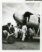
Photograph of the Lockheed 14 aircraft, Fairbanks, Alaska, July 15, 1938
Date
1938-07-15
Archival Collection
Description
The black and white view of several unidentified men and mechanics standing near the Lockheed 14 aircraft that was then being refueled. At the time, Howard Hughes was then on his Around the World Flight with the Lockheed 14 where he visited Paris, Moscow, Fairbanks, and Alaska.
Image

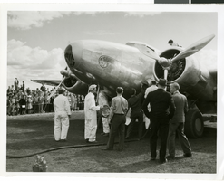
Photograph of Howard Hughes' plane at Floyd Bennet Airfield, New York, August 20, 1938
Date
1938-08-20
Archival Collection
Description
Description given with photograph: "Hughes sets new transcontinental transport mark. Floyd Bennet Field, NY--- Howard Hughes, millionaire flier, setting his famous round-the-world transport plane down here, early August 20th, after a record-smashing flight from Los Angeles. Hughes and three companions completed the trip in 10 hours 32 minutes and 20 seconds, shattering the record of 11 hours and five minutes set four years ago by Tommy Tomlinson. The flight was made most of the way in the substratosphere at an average altitude of 17, 000 feet. Credit Line ACME."
Image
#04975: Cannon, Howard - signing over papers, 1983 April 15
Level of Description
File
Archival Collection
University of Nevada, Las Vegas Creative Services Records (1980s)
To request this item in person:
Collection Number: PH-00388-02
Collection Name: University of Nevada, Las Vegas Creative Services Records (1980s)
Box/Folder: N/A
Collection Name: University of Nevada, Las Vegas Creative Services Records (1980s)
Box/Folder: N/A
Archival Component
Remarks at dedication of new Post Office in Pahrump, NV., 1967 July 09
Level of Description
File
Archival Collection
Howard Cannon Papers
To request this item in person:
Collection Number: MS-00002
Collection Name: Howard Cannon Papers
Box/Folder: Box 03 (Speeches)
Collection Name: Howard Cannon Papers
Box/Folder: Box 03 (Speeches)
Archival Component
Photograph of the Lockheed 14 aircraft, Fairbanks, Alaska, July 15, 1938
Date
1938-07-15
Archival Collection
Description
The black and white view of several unidentified men and mechanics standing near the Lockheed 14 aircraft that was then being refueled. At the time, Howard Hughes was then on his Around the World Flight with the Lockheed 14 where he visited Paris, Moscow, Fairbanks, and Alaska.
Image
Howard Hughes's plane taking off, Minneapolis, Minnesota, 1938 July 14
Level of Description
File
Archival Collection
Howard Hughes Public Relations Photograph Collection
To request this item in person:
Collection Number: PH-00373
Collection Name: Howard Hughes Public Relations Photograph Collection
Box/Folder: Folder 08
Collection Name: Howard Hughes Public Relations Photograph Collection
Box/Folder: Folder 08
Archival Component
Howard Hughes talking to W. D. Jim Guthrie at Roosevelt Field, 1938 July 18
Level of Description
File
Archival Collection
Howard Hughes Public Relations Photograph Collection
To request this item in person:
Collection Number: PH-00373
Collection Name: Howard Hughes Public Relations Photograph Collection
Box/Folder: Folder 13
Collection Name: Howard Hughes Public Relations Photograph Collection
Box/Folder: Folder 13
Archival Component
Howard Hughes and his crew thank Cordell Hull, 1938 July 21
Level of Description
File
Archival Collection
Howard Hughes Public Relations Photograph Collection
To request this item in person:
Collection Number: PH-00373
Collection Name: Howard Hughes Public Relations Photograph Collection
Box/Folder: Folder 13
Collection Name: Howard Hughes Public Relations Photograph Collection
Box/Folder: Folder 13
Archival Component