Search Results

Map of city of Las Vegas, Nevada, October 1, 1940
Date
1940-10-01
Description
'Compiled by C.D. Baker, Oct. 1, 1940.' Scale [ca. 1:11,400]. 1 in. to 950 ft. Cadastral map.
Image
Resorts International Hotel: Atlantic City, New Jersey, 1982-07-22
Level of Description
Series
Archival Collection
Martin Stern Architectural Records
To request this item in person:
Collection Number: MS-00382
Collection Name: Martin Stern Architectural Records
Box/Folder: N/A
Collection Name: Martin Stern Architectural Records
Box/Folder: N/A
Archival Component
North Las Vegas Libriary under construction and City Hall, Civic Center Drive, 1965
Level of Description
File
Archival Collection
North Las Vegas Library Photograph Collection on North Las Vegas, Nevada
To request this item in person:
Collection Number: PH-00277
Collection Name: North Las Vegas Library Photograph Collection on North Las Vegas, Nevada
Box/Folder: Folder 04
Collection Name: North Las Vegas Library Photograph Collection on North Las Vegas, Nevada
Box/Folder: Folder 04
Archival Component
Colburn's New Monthly Magazine and Humorist, no. 304. London: Chapman and Hall, 1846 April 01
Level of Description
Item
Archival Collection
Mavis Eggle "Books as They Were Bought" Collection
To request this item in person:
Collection Number: MS-01144
Collection Name: Mavis Eggle "Books as They Were Bought" Collection
Box/Folder: Box 05
Collection Name: Mavis Eggle "Books as They Were Bought" Collection
Box/Folder: Box 05
Archival Component

Map of the city of Las Vegas, Nevada, June 1, 1946
Date
1946-06-01
Description
Scale [ca. 1:9,600. 1 in. to approx. 800 ft.]. Cadastral map. 'Compiled by Pioneer Title Insurance &Trust Company.' 'By Jack Asher, State Nev. Reg. Engr. No. 305.' 'Issue 5, 6/1/46.' Includes indexes. Pioneer Title Insurance &
Trust Company
Trust Company
Image

Map of California, territories of New Mexico, Arizona, Colorado, Nevada and Utah, circa 1863
Date
1861 to 1865
Description
40 x 62 cm. Relief shown by hachures and spot heights. Prime meridians: Greenwich and Washington. "Historical and statistical view of the United States, 1860"--Verso. Atlas page numbers at top: 58-59. Arizona became a territory in 1863, and Nevada became a state on October 31, 1864, so this map was either published in 1863 or in 1864 before the end of October. Original publisher: Johnson and Ward.
Image
North Las Vegas Libriary under construction and City Hall, Civic Center Drive, 1965
Level of Description
File
Archival Collection
North Las Vegas Library Photograph Collection on North Las Vegas, Nevada
To request this item in person:
Collection Number: PH-00277
Collection Name: North Las Vegas Library Photograph Collection on North Las Vegas, Nevada
Box/Folder: Folder 04
Collection Name: North Las Vegas Library Photograph Collection on North Las Vegas, Nevada
Box/Folder: Folder 04
Archival Component
Sahara Boardwalk, Atlantic City, New Jersey, 1980; 1980 July 14
Level of Description
Series
Archival Collection
Martin Stern Architectural Records
To request this item in person:
Collection Number: MS-00382
Collection Name: Martin Stern Architectural Records
Box/Folder: N/A
Collection Name: Martin Stern Architectural Records
Box/Folder: N/A
Archival Component
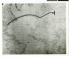
Photograph of a flight path map, 1938
Date
1938
Archival Collection
Description
Description printed on back of photograph: "Map of Howard Hughes' flight."
Image
Valley of Fire, Mount Charleston, Lost City, and Fremont Street, 1937 November 26-1938 February 14
Level of Description
File
Archival Collection
Robert Woodruff Papers
To request this item in person:
Collection Number: MS-00455
Collection Name: Robert Woodruff Papers
Box/Folder: Box 08
Collection Name: Robert Woodruff Papers
Box/Folder: Box 08
Archival Component