Search Results
Pile bridge at Milepost 7.71, St. Thomas Branch, will require new structure, 1938
Level of Description
File
Archival Collection
Union Pacific Railroad Photographs
To request this item in person:
Collection Number: PH-00043
Collection Name: Union Pacific Railroad Photographs
Box/Folder: Oversized Box 01
Collection Name: Union Pacific Railroad Photographs
Box/Folder: Oversized Box 01
Archival Component
New six span pile trestle was constructed immediately west of our present bridge, 1938
Level of Description
File
Archival Collection
Union Pacific Railroad Photographs
To request this item in person:
Collection Number: PH-00043
Collection Name: Union Pacific Railroad Photographs
Box/Folder: Oversized Box 01
Collection Name: Union Pacific Railroad Photographs
Box/Folder: Oversized Box 01
Archival Component
Constructing bridge over new channel east of existing bridge east of Pomona, California, 1938
Level of Description
File
Archival Collection
Union Pacific Railroad Photographs
To request this item in person:
Collection Number: PH-00043
Collection Name: Union Pacific Railroad Photographs
Box/Folder: Oversized Box 01
Collection Name: Union Pacific Railroad Photographs
Box/Folder: Oversized Box 01
Archival Component
Howard Hughes at a banquet held for him in the Biltmore Hotel in Los Angeles, California, 1938 August 01
Level of Description
File
Archival Collection
Howard Hughes Public Relations Photograph Collection
To request this item in person:
Collection Number: PH-00373
Collection Name: Howard Hughes Public Relations Photograph Collection
Box/Folder: Folder 16
Collection Name: Howard Hughes Public Relations Photograph Collection
Box/Folder: Folder 16
Archival Component

Map of California, Utah, Nevada, Colorado, New Mexico and Arizona, 1864
Date
1864
Description
'Johnson's California, with Utah, Nevada, Colorado, New Mexico, and Arizona, published by Johnson and Ward.' 'Entered according to Act of Congress in the Year 1864 by A.J. Johnson in the Clerks Office of the District Court of the United States for the southern district of New York.' Atlas page numbers in upper margin: 66-67. This is probably plate 67 from Johnson's New Illustrated Family Atlas, published in New York by Johnson & Ward in 1864. Shows natural features, locations of Indian tribes, proposed railroad routes, routes of explorers, trails, county boundaries and populated places ; "." ; Relief shown by hachures ; Prime meridians: Greenwich and Washington ; In top margin: 66-67 ; Hand colored ; On verso: Historical and statistical view of Mexico and central America (p. 79) and Historical and statistical view of the United States, 1860 (p. 78) Scale [ca. 1:3,484,800]. 1 in. to ca. 55 miles (W 124°--W 102°/N 42°--N 32°)
Text
#69247: New faculty members on August 15, 2013, 2013 August 15
Level of Description
File
Archival Collection
University of Nevada, Las Vegas Creative Services Records (2010s)
To request this item in person:
Collection Number: PH-00388-05
Collection Name: University of Nevada, Las Vegas Creative Services Records (2010s)
Box/Folder: Digital File 00
Collection Name: University of Nevada, Las Vegas Creative Services Records (2010s)
Box/Folder: Digital File 00
Archival Component
Samuels, Howard J., "The Off-track Betting Experiment in New York", 1973
Level of Description
File
Archival Collection
Eugene Martin Christiansen Papers
To request this item in person:
Collection Number: MS-00561
Collection Name: Eugene Martin Christiansen Papers
Box/Folder: Box 089
Collection Name: Eugene Martin Christiansen Papers
Box/Folder: Box 089
Archival Component

Map of the territories of New Mexico, Arizona, Colorado, Nevada, and Utah, 1855
Date
1855
Description
29 x 36 cm. Relief shown by hachures. Prime meridians: Greenwich and Washington. "Entered according to act of Congress in the year 1855 by J.H. Colton & Co. in the Clerk's Office of the Dist. Office of the U.S. for the Southern. Dist. of New York." Hand colored. Decorative border. Atlas p. number in lower-right margin: 67. Shows routes of explorers, proposed railroad routes, wagon route, mail route, Indian reserves and mines. On verso: History and statistical view of Mexico. Original publisher: J.H. Colton.
Image
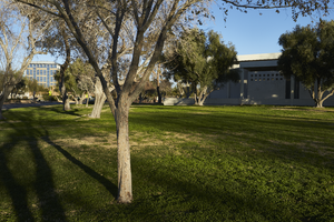
Landscaping in front of the former North Las Vegas City Hall building with new City Hall building in background in North Las Vegas, Nevada: digital photograph
Date
2019-02-06
Archival Collection
Description
From the UNLV University Libraries Photographs of the Development of the Las Vegas Valley, Nevada (PH-00394). Part of the collection documents the entire 19 mile length of the north/south Eastern Avenue / Civic Center Drive alignment. This photograph was captured in the section of Civic Center Drive between Las Vegas Boulevard and Lake Mead Boulevard.
Image
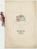
The New Fay Easter dinner menu, Sunday, April 7, 1912
Date
1912-04-07
Archival Collection
Description
Restaurant: The New Fay (Virginia, Minn.) Location: Virginia, Minnesota, United States
Text