Search Results
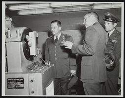
Howard Cannon during visit to Holloman Air Force Base, New Mexico with two other men: photographic print
Date
1964
Archival Collection
Description
From the Howard Cannon Photograph Collection (PH-00192). Stamped on verso: "Official Air Force Photo - Base Photo Branch - Holloman AFB, New Mexico"
Image
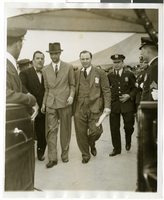
Photograph of Howard Hughes and Grover Whalen at Floyd Bennett Airfield, New York, July 14, 1938
Date
1938-07-14
Archival Collection
Description
A view of Howard Hughes being escorted by Grover Whalen and several guards at Floyd Bennett Airfield.
Image
#65841: Howard, Lisa (IT Tech) - New Faces Article, 2007 August 27
Level of Description
File
Archival Collection
University of Nevada, Las Vegas Creative Services Records (2000s)
To request this item in person:
Collection Number: PH-00388-04
Collection Name: University of Nevada, Las Vegas Creative Services Records (2000s)
Box/Folder: N/A
Collection Name: University of Nevada, Las Vegas Creative Services Records (2000s)
Box/Folder: N/A
Archival Component
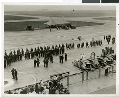
Photograph Howard Hughes arrival at Floyd Bennett Airport, New York, July 14, 2013
Date
1938-07-14
Archival Collection
Description
The black and white view of a crowd of people awaiting the arrival of Howard Hughes at Floyd Bennett Airport in New York. Typed onto a piece of paper attached to the image: "Just before world fliers landed, Floyd Bennett Airport, N.Y. -- A small army of policemen pictured on the runway here shortly before Howard Hughes and his four companions landed, ending their Round-The-World flight. Note newsreel photographers on the right. In the background is the tent from which Hughes and his fellow fliers spoke to a vast radio audience. Credit line (ACME) 7(3/4)/14/38."
Image
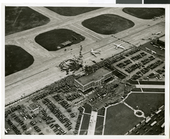
Photograph of the landing of Howard Hughes' Lockheed 14 aircraft, New York, July 14, 1938
Date
1938-07-14
Archival Collection
Description
The black and white, aerial view of Howard Hughes' Lockheed 14 aircraft performing its final landing on the Round the World flight at Floyd Bennett Airport, New York. Typed onto a piece of paper attached to the image: "Journey's End for World Fliers! Floyd Bennett Airport, N. Y. ---- The "World's Fair 1939.," Howard Hughes' silver monoplane, shown on the ground just after it landed here, concluding an amazing globe-girdling flight in total elapsed time of 3 days, 19 hours, 10 seconds. A crowd of officials surround the plane. Credit Line (ACME) 7/14/38."
Image
The New Fay Easter dinner menu, Sunday, April 7, 1912
Date
1912-04-07
Archival Collection
Description
Restaurant: The New Fay (Virginia, Minn.) Location: Virginia, Minnesota, United States
Text

Map of the territories of New Mexico, Arizona, Colorado, Nevada, and Utah, 1855
Date
1855
Description
29 x 36 cm. Relief shown by hachures. Prime meridians: Greenwich and Washington. "Entered according to act of Congress in the year 1855 by J.H. Colton & Co. in the Clerk's Office of the Dist. Office of the U.S. for the Southern. Dist. of New York." Hand colored. Decorative border. Atlas p. number in lower-right margin: 67. Shows routes of explorers, proposed railroad routes, wagon route, mail route, Indian reserves and mines. On verso: History and statistical view of Mexico. Original publisher: J.H. Colton.
Image
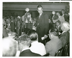
Photograph of Howard Hughes speaking at the National Press Club, New York City, July 15, 1938
Date
1938-07-15
Archival Collection
Description
Typed onto a piece of paper attached to the image: "Howard Hughes and his four companions honored at the National Press Club. Howard Hughes is speaking, with Mayor La Guardia and Secretary of State Cordell Hull at lower right. July 1938."
Image
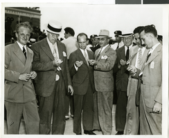
Photograph of a crowd of people awaiting the arrival of Howard Hughes, New York, July 14, 1938
Date
1938-07-14
Archival Collection
Description
The black and white view of members of the Aeronautical Association awaiting the arrival of Howard Hughes and his Lockheed 12 aircraft at the Floyd Bennett Airport in New York. Typed onto a piece of paper attached to the image: "Official timers of Aeronautical Association compare their precision chronometers as Lockheed-14 roars overhead, marking end of Round-the-World flight at Floyd Bennett Airport." Typed onto a second piece of paper also attached to the image: "Official timers of the Aeronautical Association shown at Floyd Bennett Field comparing their precision chronometers as Howard Hughes' plane roared overhead marking the end of his Flight Around The World. July 1938."
Image
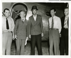
Photograph of Howard Hughes, Tom Thurlow, Harry Connor, Richard Staddart, and Dale Powers, New York, July 4, 1938
Date
1938-07-04
Archival Collection
Description
Howard Hughes, Tom Thurlow, Harry Connor, Richard Staddart, and Dale Powers with an unidentified aircraft behind them in New York. Typed on a piece of paper attached to the image: "Hughes flies to New York for hop to Paris. L to R L. Tom Thurlow and Harry Connor, Hughes, Richard Stoddart and Dale Powers. 7/4/1938."
Image