Search Results

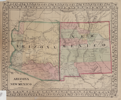
Map of Arizona and New Mexico, 1867
Date
1867
Description
26 x 32 cm. Relief shown by hachures. "Entered according to act of Congress in the year 1867 by S. Augustus Mitchell in the Clerks Office of the District Court for the Eastern District of Pennsylvania." Includes decorative border of grape vines. Shows Tucson as capital of Arizona; shows various trails including Cook's Wagon Route, Marcy's Route, and Kearney's Route. Written in pencil in lower right corner: 135. Original publisher: S.A. Mitchell.
Image
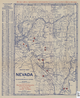
Sketch map of Nevada and the southeastern portion of California, 1906
Date
1906
Description
42 x 29 cm. Relief shown by hachures. Copyright held by George S. Clason. "Compliments of the Patrick Investment Co. ... Denver, Colorado." Includes index. Shows railroad routes. "We have offices, representatives and properties in every camp marked in red on this map." Original publisher: Clason Map Co..
Image