Search Results
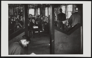
Volunteers of the Civilian Conservation Corps celebrating Christmas in the recreation hall of their camp in Boulder City, Nevada: photographic print
Date
1939-12
Archival Collection
Description
From the T.M. Parsons Photograph Collection (PH-00258) -- Recreation hall at camp number NP-6, Company 2536 Former Six Companies'.
Image
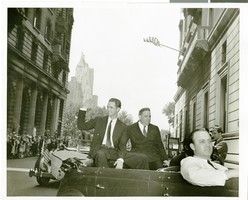
Photograph of Howard Hughes at his parade for Round the World flight, New York City, July 15, 1938
Date
1938-07-15
Archival Collection
Description
Typed onto the back of the image: "New York welcomes Howard Hughes. Howard Hughes and Mayor La Guardia in car. 7/15/38."
Image
Construction of library, City Hall and aerial photographs of North Las Vegas Library, 1965-1966
Level of Description
File
Archival Collection
North Las Vegas Library District Collection on Nevada
To request this item in person:
Collection Number: MS-00651
Collection Name: North Las Vegas Library District Collection on Nevada
Box/Folder: Box 12
Collection Name: North Las Vegas Library District Collection on Nevada
Box/Folder: Box 12
Archival Component
Negative: Oran K. Gragson and another person in his office at City Hall, 1961 December 21
Level of Description
File
Archival Collection
Oran K. Gragson Photographs
To request this item in person:
Collection Number: PH-00310
Collection Name: Oran K. Gragson Photographs
Box/Folder: Box SH-032
Collection Name: Oran K. Gragson Photographs
Box/Folder: Box SH-032
Archival Component
Plan entitled "New City Hall" and other unidentified building and site plans, 2009, undated
Level of Description
File
Archival Collection
Mark L. Fine Papers
To request this item in person:
Collection Number: MS-00696
Collection Name: Mark L. Fine Papers
Box/Folder: Oversized Box 7
Collection Name: Mark L. Fine Papers
Box/Folder: Oversized Box 7
Archival Component
City Swiss Club, annual banquet, menu, at The Monico International Hall, 1902 December 12
Level of Description
Item
Archival Collection
Bohn-Bettoni Menu Collection
To request this item in person:
Collection Number: MS-00793
Collection Name: Bohn-Bettoni Menu Collection
Box/Folder: Box 07
Collection Name: Bohn-Bettoni Menu Collection
Box/Folder: Box 07
Archival Component
North Las Vegas Libriary under construction and City Hall, Civic Center Drive, 1965
Level of Description
File
Archival Collection
North Las Vegas Library Photograph Collection on North Las Vegas, Nevada
To request this item in person:
Collection Number: PH-00277
Collection Name: North Las Vegas Library Photograph Collection on North Las Vegas, Nevada
Box/Folder: Folder 04
Collection Name: North Las Vegas Library Photograph Collection on North Las Vegas, Nevada
Box/Folder: Folder 04
Archival Component
Howard Hughes sitting in his XF-11 near Culver City, California, 1946
Level of Description
File
Archival Collection
Howard Hughes Public Relations Photograph Collection
To request this item in person:
Collection Number: PH-00373
Collection Name: Howard Hughes Public Relations Photograph Collection
Box/Folder: Folder 22
Collection Name: Howard Hughes Public Relations Photograph Collection
Box/Folder: Folder 22
Archival Component