Search Results
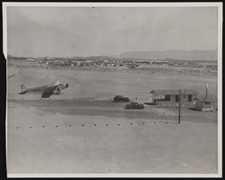
Photograph of an airport, Boulder City (Nev.), March 30, 1937
Date
1937-03-30
Archival Collection
Description
A photograph taken by Rupert B. Spearman of the hub of the Boulder City Airport as seen from the roof of the Grand Canyon Airlines hanger on March 30, 1937. Site Name: Boulder City Municipal Airport (Boulder City, Nev.)
Image

Map of California and territories of New Mexico and Utah, circa 1861
Date
1859 to 1862
Description
'Compiled, drawn, and engraved under the supervision of J.H. Colton and A.J. Johnson.' Relief shown by hachures and spot heights. Scale [ca. 1:3,041,280]. 1 in. to approx. 48 miles (W 124°--W 103°/N 42°--N 31°). Hand colored
Prime meridians: Greenwich and Washington
Plates 54 & 55 removed from Johnson's New illustrated family atlas of the world, with descriptions geographical, statistical and historical ... New York, 1862
Title page of atlas.
Prime meridians: Greenwich and Washington
Plates 54 & 55 removed from Johnson's New illustrated family atlas of the world, with descriptions geographical, statistical and historical ... New York, 1862
Title page of atlas.
Image

Photograph of the Lockheed 14 aircraft, July 14, 1938
Date
1938-07-14
Archival Collection
Description
The black and white, skyline view of New York City with Lockheed 14 aircraft flying in the foreground.
Image
Crowd greeting Howard Hughes at Floyd Bennett Field Airport, 1938 July 14
Level of Description
File
Archival Collection
Howard Hughes Public Relations Photograph Collection
To request this item in person:
Collection Number: PH-00373
Collection Name: Howard Hughes Public Relations Photograph Collection
Box/Folder: Folder 08
Collection Name: Howard Hughes Public Relations Photograph Collection
Box/Folder: Folder 08
Archival Component
Howard Hughes behind his plane at Le Bourget Airfield, France, 1938 July
Level of Description
File
Archival Collection
Howard Hughes Public Relations Photograph Collection
To request this item in person:
Collection Number: PH-00373
Collection Name: Howard Hughes Public Relations Photograph Collection
Box/Folder: Folder 06
Collection Name: Howard Hughes Public Relations Photograph Collection
Box/Folder: Folder 06
Archival Component