Search the Special Collections and Archives Portal
Search Results

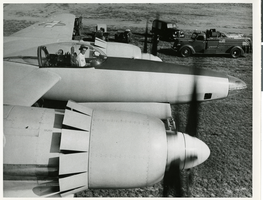
Photograph of Howard Hughes in the cockpit of the XF-11 preparing for his first test flight in Culver City, California July 7, 1947
Date
1947
Archival Collection
Description
Howard Hughes sits in the cockpit of the XF-11, a reconnaissance plane that Hughes built and designed in conjunction with Air Materiel Command engineers. Hughes is preparing for his first test flight in Culver City, California July 7, 1947.
Image

Photograph of Boulder City Company Store, Boulder City (Nev.), April 6, 1932
Date
1932-04-06
Archival Collection
Description
Boulder City Company Store at night. This completely equipped store provided for the needs of the Boulder Dam (now called Hoover Dam) construction workmen.
Image

Photograph of Howard Hughes and his crew at a parade, New York, July 15, 1938
Date
1938-07-15
Archival Collection
Description
The black and white view of Howard Hughes and his crew at a parade after he completed his Round-The-World flight in New York.
Image

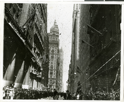
Photograph of a parade procession for Howard Hughes, New York, July 15, 1938
Date
1938-07-15
Archival Collection
Description
A picture of the crowd at a parade celebrating the completion of Howard Hughes' round the world flight. Typed onto a piece of paper attached to the image: "Parade - 7/15/38."
Image

Film transparency of Boulder City Visitors Bureau, Boulder City, Nevada, 1969
Date
1969
Archival Collection
Description
An image of the Visitors Bureau located on Arizona Street in Boulder City at night. Text across the white sign mounted on the front of the building: "Free Movies Building Of The Dam."
Image

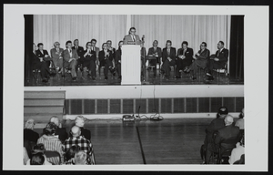
Officials present for Boulder City's incorporation ceremony in Boulder City, Nevada: photographic print
Date
1964-03-16
Archival Collection
Description
From the UNLV Libraries Single Item Accession Photograph Collection (PH-00171). L-R: unidentified; Art Olson, Clark County Commissioner; Harold Corbin, U.S. Bureau of Reclamation and Boulder City Manager; Dr. Henry J. Reining, Dean of the College of Administration, USC at Los Angeles; Albert Franklin, Boulder City Councilman; Bob Broadbent, Boulder City Mayor; Dr. Thomas S. White, Boulder City Councilman; Grant Sawyer, Governor of Nevada; William Byrne, Henderson, Nevada mayor; Morgan J. Sweeney, Boulder City Councilman; Arleigh West, Acting Regional Director, Bureau of Reclamation at Boulder City; Joe Manix, Boulder City Councilman; N.E. Broadbent, Mayor of Ely, Nevada; B. Mahlon Brown, Nevada state senator; Harley Harmon, Clark County Commission Chairman; Jake Dieleman, Nevada state assemblyman.
Image

Las Vegas Valley as seen from the City View Trail above Sun City MacDonald Ranch, Henderson, Nevada
Date
2016-09-14
Archival Collection
Description
Images of the Las Vegas Valley as seen from City View Trail above the Sun City MacDonald Ranch neighborhood of Henderson, Nevada.
Image

Las Vegas Valley as seen from the City View Trail above Sun City MacDonald Ranch, Henderson, Nevada
Date
2016-09-14
Archival Collection
Description
Images of the Las Vegas Valley as seen from City View Trail above the Sun City MacDonald Ranch neighborhood of Henderson, Nevada.
Image
Las Vegas City Attorney Howard Cannon pictured with Las Vegas city officials. Left to right are R. W. Notti (Assistant City Manager), A. H. Kennedy (City Manager), Cannon, Shirley Ballinger (City Clerk), Mayor C. D. Baker, Commissioner E. W. Fountain, Commissioner Reed Whipple, Commissioner Harris P. Sharp, and Commissioner Wendell Bunker: photographic print and photographic negative, approximately 1950 to 1958
Level of Description
Item
Archival Collection
Howard Cannon Photograph Collection
To request this item in person:
Collection Number: PH-00192
Collection Name: Howard Cannon Photograph Collection
Box/Folder: Folder 03, Box SH-026
Collection Name: Howard Cannon Photograph Collection
Box/Folder: Folder 03, Box SH-026
Archival Component

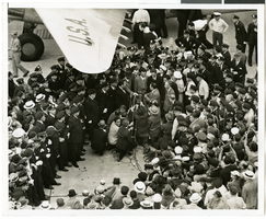
Photograph of Howard Hughes and crowds at Floyd Bennett Airfield, New York, July 14, 1938
Date
1938-07-14
Archival Collection
Description
The black and white view of Howard Hughes and his crew being surrounded by crowds as they exit the Lockheed 14 aircraft after finishing the Around the World flight at Floyd Bennett Airfield in New York. Description printed on photograph's accompanying sheet of paper: "Telling the world about Hughes' record flight. New York City-- Radio men setting up their microphones in front of the crew of Howard Hughes great Lockheed plane so that Hughes and his heroic crew could send a few words of greeting to the world over the air waves after their record smashing flight around the world. Credit Line (ACME) 7/14/38 (SS)"
Image
Pagination
Refine my results
Content Type
Creator or Contributor
Subject
Archival Collection
Digital Project
Resource Type
Year
Material Type
Place
Language
Records Classification
