Search Results

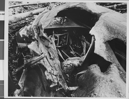
Photograph of crash of Howard Hughes' XF-11, Culver City, California, July 07, 1946
Date
Archival Collection
Description
Image

Photograph of crash of Howard Hughes' XF-11, Culver City, California, July 07, 1946
Date
Archival Collection
Description
Image

Photograph of crash of Howard Hughes' XF-11, Culver City, California, July 07, 1946
Date
Archival Collection
Description
Image
Photograph of crash of Howard Hughes' XF-11, Culver City, California, July 07, 1946
Date
Archival Collection
Description
Image

Photograph of crash of Howard Hughes' XF-11, Culver City, California, July 07, 1946
Date
Archival Collection
Description
Image

City of Las Vegas map, 1952
Date
Description
Text
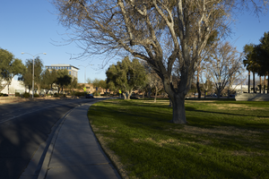
Landscaping along Civic Center Drive near City Hall in North Las Vegas, Nevada: digital photograph
Date
Archival Collection
Description
From the UNLV University Libraries Photographs of the Development of the Las Vegas Valley, Nevada (PH-00394). Part of the collection documents the entire 19 mile length of the north/south Eastern Avenue / Civic Center Drive alignment. This photograph was captured in the section of Civic Center Drive between Las Vegas Boulevard and Lake Mead Boulevard.
Image
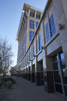
Exterior view of the North Las Vegas City Hall building in North Las Vegas, Nevada: digital photograph
Date
Archival Collection
Description
From the UNLV University Libraries Photographs of the Development of the Las Vegas Valley, Nevada (PH-00394). Part of the collection documents the entire 19 mile length of the north/south Eastern Avenue / Civic Center Drive alignment. This photograph was captured in the section of Civic Center Drive between Las Vegas Boulevard and Lake Mead Boulevard.
Image
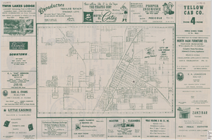
Street map of the city of Las Vegas, 1954
Date
Description
Image
Crowd of Hughes Tool Company employees holds a welcome rally for Howard Hughes in Houston, Texas, 1938 July 30
Level of Description
Archival Collection
Collection Name: Howard Hughes Professional and Aeronautical Photographs
Box/Folder: Folder 06
Archival Component