Search the Special Collections and Archives Portal
Search Results
Shaffer, Howard J., Matthew N. Hall, and Joni Vander Bilt, "Estimating the Prevalence of Disordered Gambling Behavior in the United States and Canada: A Meta-Analysis" report, 1997 December 15
Level of Description
Archival Collection
Collection Name: Katherine A. Spilde Papers on Native American Gaming
Box/Folder: Box 72
Archival Component

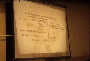
Slide presentation from a hearing at a City Hall in Nevada: photographic slide
Date
Archival Collection
Description
From the Sister Klaryta Antoszewska Photograph Collection (PH-00352). The presentation slide reads, "Total announced tests and radiation measured off the test range complex. Total above-ground tests = 126. Total sub0surface tests = 413. Total tests = 539. Number measured off the test range complex of above-ground tests = 89. Number measured off the test range complex of sub-surface tests = 40. Total number measured off the test range complex = 129."
Image
Howard Hughes sitting inside of a B-23 converted bomber before taking off for New York City in Los Angeles, California, 1946 September 11
Level of Description
Archival Collection
Collection Name: Howard Hughes Public Relations Photograph Collection
Box/Folder: Folder 22
Archival Component
Howard Hughes sitting inside of a B-23 converted bomber before taking off for New York City in Los Angeles, California, 1946 September 11
Level of Description
Archival Collection
Collection Name: Howard Hughes Public Relations Photograph Collection
Box/Folder: Folder 22
Archival Component
Howard Hughes sitting inside of a B-23 converted bomber before taking off for New York City in Los Angeles, California, 1946 September 11
Level of Description
Archival Collection
Collection Name: Howard Hughes Public Relations Photograph Collection
Box/Folder: Folder 22
Archival Component

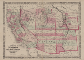
Map of California, with territories of Utah, Nevada, Colorado, New Mexico, and Arizona, 1864
Date
Description
Image
Howard Hughes talking with William Powell, Veronica Lake, André De Toth, and Johnny Meier, Hughes Public Relations head at the 21 Club in New York City, New York, 1946 February 17
Level of Description
Archival Collection
Collection Name: Howard Hughes Professional and Aeronautical Photographs
Box/Folder: Folder 07
Archival Component
Remarks at the dedication of North Las Vegas City Hall, 1966 December 04
Level of Description
Archival Collection
Collection Name: Howard Cannon Papers
Box/Folder: Box 02 (Speeches)
Archival Component

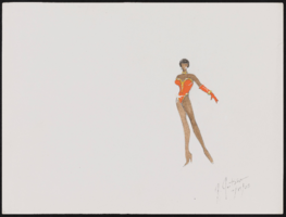
Aretha Franklin at Carnegie Hall, New York: costume design drawings, notes
Date
Archival Collection
Description
Series III. Professional work in the United States: show production materials -- Revues, concerts, and theater production materials
Mixed Content
Harry Hall oral history interview
Identifier
Abstract
Oral history interview with Harry Hall conducted by Dennis McBride on June 20, 1986 for the Boulder City Library Oral History Project. Hall discusses how the hope of work on the dam encouraged his move to Nevada with his mother and stepfather. He then talks at some length about living in a tent in Ragtown, the various illegal bootlegging establishments along the dirt road running between Las Vegas and Boulder City, Nevada, and working on the dam. He continues talking about working conditions, the heat, and the labor strike at the dam in August, 1931.
Archival Collection
