Search Results


neo000139-003
Description
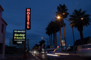
Sign animation: Chasing, flashing, oscillating
Notes: the letters inside of the letters of the tower actually oscillate.
Notes: the letters inside of the letters of the tower actually oscillate.


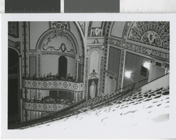
Photograph of the interior of the Shubert Theatre, Cincinnati (Ohio), 1970
Date
1970
Archival Collection
Description
The Shubert Theatre stage as seen from the upper house left side of the balcony seats. Two sections of box seats are visible. The intricate wall designs are visible above the box seats and above the exit for the balcony rows. The 3,000 seat Shubert Theater was built inside what was originally the city’s original YMCA (which opened in 1848). The theater opened in 1921 as a venue for legitimate theatrical performances. The Shubert Theater switched to a combined use venue for movies and stage shows in 1935. The theater was closed in 1953 and reopened as Rev. Earl Ivies' Revival Temple. Just two years later, however, the Shubert Theater was renovated and once again returned to legitimate theater. In 1976, the Shubert Theater was demolished to make way for a parking lot. Today, there is an office building on the site. Site Name: Shubert Theater (Cincinnati, Ohio) Street Address: 90 East 7th Street
Image
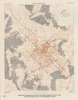
Index map showing locations of geologic sections on plate 2 and wells on plates 2 and 3, Las Vegas Valley, Nevada, 1981 (Water-supply paper 2320-A)
Date
1981
Description
'Department of the Interior, U.S. Geological Survey. Water-supply paper 2320-a, plate 4.' 'Prepared in cooperation with the Clark County Department of Comprehensive Planning.' 'Base from U.S. Geological Survey 1:100,000 , Boulder City, Ariz.-Nev., Las Vegas, Nev.-Calif., Mesquite Lake, Nev.-Calif., 1978, Lake Mead, Nev.-Ariz., 1979.' 'Geology from Malmberg (1965); Longwell and others (1965); Bell and Smith (1980); and J. R. Harrill, 1976.' Shows township and range lines. Scale 1:100,000 (W 115°30´--W 115°00´/N 36°30´--N 36°00´). Series: U.S. Geological Survey water-supply paper
2320-A. Originally published as plate 4 of Ground-water conditions in Las Vegas Valley, Clark County, Nevada. Part I. Hydrogeologic framework / by Russell W. Plume, published by the U.S. Geological Survey in 1989 as Water-supply paper 2320-A.
2320-A. Originally published as plate 4 of Ground-water conditions in Las Vegas Valley, Clark County, Nevada. Part I. Hydrogeologic framework / by Russell W. Plume, published by the U.S. Geological Survey in 1989 as Water-supply paper 2320-A.
Image