Search the Special Collections and Archives Portal
Search Results
Valley of Fire, Mount Charleston, Lost City, and Fremont Street, 1937 November 26-1938 February 14
Level of Description
File
Archival Collection
Robert Woodruff Papers
To request this item in person:
Collection Number: MS-00455
Collection Name: Robert Woodruff Papers
Box/Folder: Box 08
Collection Name: Robert Woodruff Papers
Box/Folder: Box 08
Archival Component

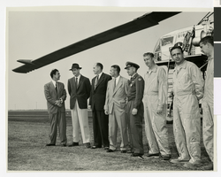
Photograph of Howard Hughes and others with the XH-17 helicopter, Culver City, California, October 23, 1952
Date
1952
Archival Collection
Description
Howard Hughes (second from left) standing in front of the experimental helicopter XH-17, Flying Crane, with others (from left to right): Rea Hopper, Director of the Aeronautical Division, Hughes Aircraft Company; Hughes; Clyde Jones, Director of Engineering, Hughes Tool Company Aeronautical Division; Warren Reed, Assistant; Colonel Carl E. Jackson from Air Research and Development Headquarters, Baltimore; Gale J. Moore, Pilot; possibly Chal Bowen, Flight Engineer/Co-pilot, and an unidentified man, on October 23, 1952.
Image
William D. Howard, Marcus Howard, Nancy Howard Copley, Mary Josephine Baxter Howard, Ollie Howard Lohr, Allie Howard Moxley, Lyght Howard, and Minnie Howard, Oregon, undated
Level of Description
File
Archival Collection
Josephine Johnson Foster Photograph Collection
To request this item in person:
Collection Number: PH-00056
Collection Name: Josephine Johnson Foster Photograph Collection
Box/Folder: Folder 01
Collection Name: Josephine Johnson Foster Photograph Collection
Box/Folder: Folder 01
Archival Component
Howard Hughes sitting in his XF-11 near Culver City, California, 1946
Level of Description
File
Archival Collection
Howard Hughes Public Relations Photograph Collection
To request this item in person:
Collection Number: PH-00373
Collection Name: Howard Hughes Public Relations Photograph Collection
Box/Folder: Folder 22
Collection Name: Howard Hughes Public Relations Photograph Collection
Box/Folder: Folder 22
Archival Component

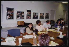
Union hall meetings and activities, Culinary Union, Las Vegas (Nev.), 1994, image 15
Date
1994
Description
Arrangement note: Series III. Internal: Work
Image
Pagination
Refine my results
Content Type
Creator or Contributor
Subject
Archival Collection
Digital Project
Resource Type
Year
Material Type
Place
Language
Records Classification
