Search Results
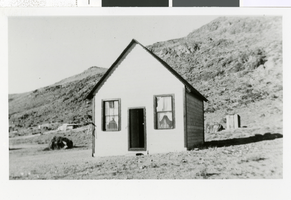
Photograph of a schoolhouse, Warm Springs (Nev.), 1937-1938
Date
1937 to 1938
Archival Collection
Description
A picture of a schoolhouse located 50 miles from Tonopah and 40 miles west of Ely. Transcribed from the notes attached to the picture, "Indians left 5- or 6 children m/m Wilson Dubin m/m Wolf Tibo had seen close bar, had a bar, natural springs."
Image
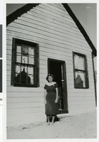
Photograph of a schoolhouse, Warm Springs (Nev.), 1937-1938
Date
1937 to 1938
Archival Collection
Description
A close-up of Alberta Chloe Calvin in front of a schoolhouse. The schoolhouse had only two students.
Image
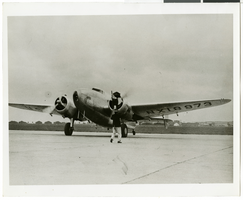
Photograph of the Lockheed 14 aircraft at Le Bourget Airfield, France, 1938
Date
1938
Archival Collection
Description
The black and white view of the Lockheed plane is shown as it taxied to a stop at Le Bourget Airfield near Paris, after a record-shattering flight across the Atlantic.
Image
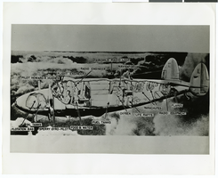
Photograph of a diagram showing the Lockheed 14 aircraft, June 10, 1938
Date
1938-06-10
Archival Collection
Description
A diagram showing various components of Lockheed 14 aircraft.
Image
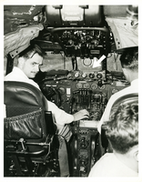
Photograph of Howard Hughes at the TWA Constellation controls, May 1, 1947
Date
1947-05-01
Archival Collection
Description
Howard Hughes at the controls of a TWA Constellation aircraft, demonstrating his new radar safety device, May 1, 1947.
Image
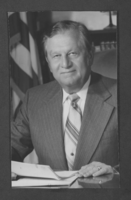
Photograph of Howard Cannon, Las Vegas, Nevada, circa 1980s
Date
1980 to 1989
Archival Collection
Description
U.S. Senator Howard Cannon.
Image
Howard Hughes Medical Institute
Level of Description
File
Archival Collection
Hughes Electronics Corporation Records
To request this item in person:
Collection Number: MS-00485
Collection Name: Hughes Electronics Corporation Records
Box/Folder: N/A
Collection Name: Hughes Electronics Corporation Records
Box/Folder: N/A
Archival Component
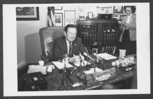
Photograph of Howard Cannon, Las Vegas, Nevada, circa 1980s
Date
1980 to 1989
Archival Collection
Description
U.S. Senator Howard Cannon sitting at his desk with an unidentified woman in the background. Microphones and tape recorders are on top of the desk.
Image
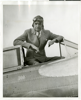
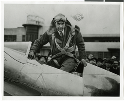
Photograph of Howard Hughes in his plane, January 1936
Date
1936-01
Archival Collection
Description
Black and white photograph of Howard Hughes posing in the cockpit of his plane, probably the Northrop Gamma Racer.
Image
Howard Hughes at the Newark Airport, New Jersey, January 1937
Date
1937-01
Archival Collection
Description
Howard Hughes alighting from his plane at Newark Airport after establishing a new transcontinental record.
Image