Search the Special Collections and Archives Portal
Search Results
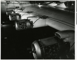
Photograph of Flying Boat engines after test flight, circa 1947
Date
1947
Archival Collection
Description
Press release attached to photo: "HUGHES FLYING BOAT Howard Hughes' massive wooden flying boat, which flew November 2, 1947, is shown in its Long Beach hangar in the first official photograph released since its flight. The airplane, with a wing span of 320 feet, remains today the largest ever constructed. The U. S. Navy has expressed interest in it for experimentation, although no transaction has yet been made." Stamped on photo: "HUGHES HELICOPTERS DIVISION OF SUMMA CORPORATION CULVER CITY, CALIFORNIA." Los Angeles Harbor is now known as Long Beach Harbor.
Image
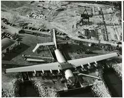
Aerial photograph of Hughes Flying Boat ready for tests, Terminal Island, California, October 13, 1946
Date
1946-10-13
Archival Collection
Description
Press Release attached to photo: "HUGHES HERCULES READY FOR TESTS. LONG BEACH, CAL. An aerial view shows Howard Hughes' giant plywood seaplane Hercules ready for taxi tests at Long Beach. The initial flight of the plane, which cost $20,000,000 and will seat 700 persons, will not be attempted until early in 1947. ACME 10/13/46." Los Angeles Harbor, Terminal Island are now known as Long Beach.
Image
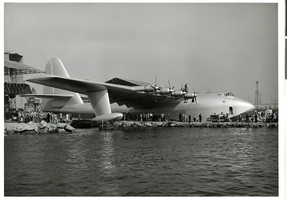
Photograph of launching world's largest plane, Los Angeles Harbor, November 1, 1947
Date
1947-11-01
Archival Collection
Description
Press release attached to back of photo: "LAUNCHING WORLD'S LARGEST PLANE The Hughes Flying boat was launched for the first time November 1, 1947. After the three concrete docks, one containing the hull and two the wing pontoons, were pumped with sea water to the outside level, gates were lowered and the Flying Boat was carefully towed forward by tractors, and by boats as the tail cleared the dock. During taxi tests the following day Howard Hughes made a surprise flight of a mile." Stamped on back of photo: "Hughes Aircraft Photo" and the date "Nov 1 1947." Los Angeles Harbor is now known as Long Beach.
Image
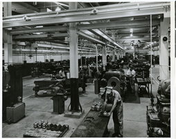
Photograph of new machine shop for Research, Product and Metallurgical engineering departments, circa 1924
Date
1924
Archival Collection
Description
Transcribed from press release attached to photograph: "LABORATORY MACHINE SHOP SPEEDS PRODUCT RESEARCH The Hughes Laboratory machine shop is devote to the building of full-scale test models of rock bits, tool joints and other drilling tools for laboratory and field testing. In connection with the latter, the shop is equipped to manufacture these tools in sufficient quantities to make possible extensive and simultaneous field trials. The machine shop handles a large amount of work for the Research, Product and Metallurgical engineering departments. This includes building new designs, new machines and new devices for preliminary testing."
Image
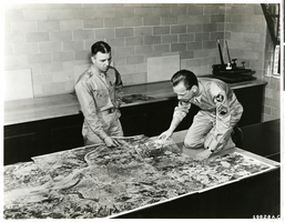
Photograph of aerial photographic map viewed by Lt Marvin R. Williams and Sgt. Erickson, circa 1940s-1950s.
Date
1940 to 1959
Archival Collection
Description
Sergeant Stanley R. Erickson puts together an aerial photographic map while Lieutenant Marvin R. Williams of Sligo, Pennsylvania looks on. Sergeant Erickson is the son of Mr. and Mrs. Gustav Erickson of 1922 Bernice Avenue, Chicago, Illinois. Erickson is a member of a mapping group in the Army Air Forces that was working with the Howard Hughes Company. The photo has the identification 19828 A. C. in the bottom right corner.
Image
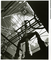
Photograph of Hughes Tool Company Derrick, Houston Texas, circa 1940s-1950s
Date
1940 to 1959
Archival Collection
Description
Transcribed from press release: "HUGHES TEST DERRICK This 118-foot field-size oil derrick tower above a block-long laboratory in Houston, Texas, where the Hughes Tool Company simulates every drilling condition in the world in order to produce tough, long-lasting drill bits for the oil industry. Rock bits are responsible for tapping of deep oil fields where today 90 per cent of the world's oil is found."
Image
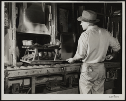
Photograph of a worker at Hughes Tool Company, Houston, Texas, circa 1940s-1950s
Date
1940 to 1959
Archival Collection
Description
Press release attached to back of photo: "A roughneck fits a new Hughes Jet bit into the drill collar preparatory to running the drill stem into the hold. In 1953 more than 500,000 rock bits produced by the Hughes Tool Company of Houston, Texas, were used in the United States alone. The invention of the rock bit by Howard R. Hughes, Sr., made it possible to drill far deeper into the earth beyond the shallow oil deposits which are now practically exhausted. Without rotary drilling equipment of this kind the world might revert to a horse and buggy economy."
Image
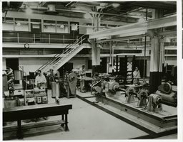
Photograph of the interior of Hughes Tool Co., Houston, Texas, circa 1950s
Date
1950 to 1959
Archival Collection
Description
Transcribed from attached press release: HUGHES TOOL COMPANY Cornerstone of the industrial empire of Howard Hughes is the Hughes Tool Company of Houston, Texas, which last year produced more than half a million rock bits for drilling the kind of deep wells now producing 90 per cent of the world's petroleum. In the company's mechanical testing section (above) engineers test the products under conditions simulating actual drilling. Howard Hughes' father's invention of the rock bit is believed to be one of the most important industrial developments of the century; without such a tool we might still be living in a horse and buggy era."
Image
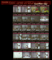
Photographs of banquet honoring Circus Circus executive Bill Bennett, culinary supporter during Frontier Strike, Culinary Union, Las Vegas (Nev.), 1990s (folder 1 of 1)
Date
1990 to 1999
Archival Collection
Description
Arrangement note: Series III. Internal: Work
Image
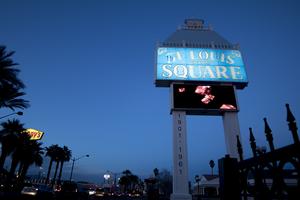
Photographs of St Louis Square sign at dusk, Las Vegas (Nev.), March 3, 2017
Date
2017-03-03
2017-09-08
Archival Collection
Description
The St. Louis Square sign sits in early evening light near the intersection of South Las Vegas Boulevard and East Louis Avenue. Information about the sign is available in the Southern Nevada Neon Survey Data Sheet.
Site address: 1945, 1921 S Las Vegas Blvd
Sign owner: St. Louis Square Inc.
Sign details: The original construction of this building was in 1987 as a shopping center. Currently this complex holds a variety of health centers.
Sign condition: 4- Has had some weathering but still in good condition
Sign form: Porte Cochere
Sign-specific description: Along Las Vegas Blvd. this Porte Cochere is placed right by the driveway to get into the parking lot with two white steel block beams as the base. There is a rectangular plasma screen that acts as a changing advertising screen. Above this there is a light blue rectangle with white plastic letters "St. Louis Square" in a subtle calligraphy font. Above this rectangle looks as though it is the light blue roof of a building, and actually matches what the roofs of the buildings in this complex.
Sign - type of display: Backlit plastic letters and LED screen
Sign - media: Steel and Plastic
Sign - non-neon treatments: Plasma screen and backlit plastic
Sign environment: Along Las Vegas Blvd. South this property in nearly across the street from the Stratosphere and about a block south of the Rummel Motel. This area is considered the transitional area between the strip and downtown.
Sign - thematic influences: Their sign relates to the property since it showcases the light blue roof which matches the buildings they have.
Sign - artistic significance: The theme of St. Louis is showcased throughout the architecture of the buildings and the sign.
Survey - research locations: Assessor's website
Surveyor: Emily Fellmer
Survey - date completed: 2017-09-08
Sign keywords: Backlit; Plastic; Steel; Plasma display; Pylon
Mixed Content
Pagination
Refine my results
Content Type
Creator or Contributor
Subject
Archival Collection
Digital Project
Resource Type
Year
Material Type
Place
Language
Records Classification
