Search Results
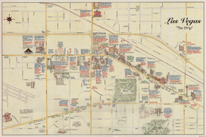
Maps of the Las Vegas Strip, downtown and metropolitan Las Vegas area, the Grand Canyon and southern Nevada, circa 1997
Date
1995 to 1999
Description
'Detail maps for downtown, neighborhoods, out of town, Grand Canyon' -- front panel. Maps on verso: Downtown -- Out of town and short adventures -- Greater Las Vegas -- Grand Canyon, South Rim Village. Major buildings and points of interest on the Las Vegas Strip shown pictorially. Includes text and notes. Originally published by MapEasy, Inc. Scale [ca. 1:10,560. 1 inch to approximately 1/6 mile].
Text
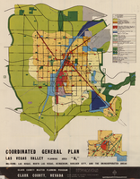
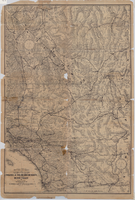
Map showing coordinated general plan for Las Vegas Valley, Planning Area A5, circa 1965-1968
Date
1963 to 1970
Description
Subtitle:'Including Las Vegas, North Las Vegas, Henderson, Boulder City, and the unincorporated areas.' 'Clark County Master Planning Program, Clark County, Nevada.' 'Eisner-Stewart and Associates, Planning Consultants, South Pasadena, California.' Includes inset of Boulder City. Text on verso about the general plan for the Las Vegas Valley, Clark County Master Planning Program Area. Published between 1965 and 1968? Scale [ca. 1:84,269. 1 inch to approximatley 1 1/3 miles].
Text

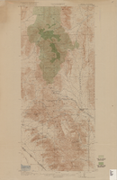
Topographic map of the Las Vegas Valley and surrounding northern and western mountain ranges, 1943
Date
1943
Description
'Edition of Mar. 1908, reprinted 1943.' 'E.M. Douglas, Geographer in charge. Topography and triangulation by R.H. Chapman, B.D. Stewart, J.E. Blackburn and D.F.C. Moor. Surveyed in 1906-1907.' Scale 1:250,000 ; polyconic proj. (W 116°00´--W 115°00´/N 37°00´--N 36°00´). Relief shown by contours and spot heights. 'Contour interval 100 feet.' 'Datum is mean sea level.' Includes township and range lines. Text and illustrations from the Topographic maps of the United States series on verso. Series: The topograhic maps of the United States. Map includes the Desert Range; Sheep Range; Pintwater Range; Las Vegas Range; Spring Mountains; Indian Springs Valley; Spotted Range. United States, Dept. of the Interior, Geological Survey
Text
Maps of flood-prone areas in Las Vegas, Nevada, 1973
Date
1973
Description
'Prepared by the U.S. Department of the Interior, Geological Survey, in cooperation with the U.S. Department of Housing and Urban Development, Federal Insurance Administration. 1973.' Sheet 1: Las Vegas NE, Nev.; Sheet 2: Las Vegas SE, Nev.; Sheet 3:Las Vegas SW, Nev.; Sheet 4: Las Vegas NW, Nev. Published by Geological Survey (U.S.). Scale 1:24,000. [1 in. to approx. 2,000 ft.]. Relief shown by contours. Flood information overprinted on U.S. Geological Survey 7.5 minute topographic quadrangles: [sheet 1] Las Vegas NE quadrangle, [sheet 2] Las Vegas SE quadrangle, [sheet 3] Las Vegas SW quadrangle, [sheet 4] Las Vegas NW quadrangle, 1967. Shows areas subject to flooding by a flood that has 1 in 100 chance on the average of occurring in any one year. "Flood boundaries were estimated from: regional stage-frequency relations." Includes notes.
Image
Satellite image map of the Las Vegas Valley, 1981
Date
1981
Description
'1981. Experimental edition 36114-A1-SI-250.' Scale 1:250,000 ; Transverse Mercator proj. (W 116°--W 114°/N 37°--N 36°). Series: Western United States 1:250,000. Western United States 1:250,000 ; NJ 11-12. Filing title: Las Vegas, Nev.; Ariz.; Calif. 'Imagery recorded with Multispectral Scanner (MSS) on NASA Landsat-3.' Includes image coverage diagram. Separate map on verso: Las Vegas / prepared by the U.S. Army Topographic Command ; revised by the U.S. Geological Survey 1969. Ed. 5. Washington, D.C. : Geological Survey, 1976, NJ 11-12 in the series Western United States 1:250,000. United States Geological Survey
Image
Map of a portion of southern California and southwestern Nevada embracing the arid region of Mojave & Colorado Deserts including Death Valley, circa 1936
Date
1934 to 1938
Description
78 x 52 cm. Relief shown by hachures and spot heights. Panel title: Road map of the Mojave and Colorado Deserts including Death Valley National Monument. In lower right-hand corner: 1379. In lower left-hand corner: Burke-Douglas. Indexes on verso to cities, towns, stations, junctions, resorts and natural features. On verso: Map showing roads and points of interest in Death Valley & vicinity. Originally folded to 27 x 11 cm. Original publisher: The Club.
Image

Topographic map of Arrow Canyon dam and reservoir site on the Muddy River, 1934
Date
1934
Archival Collection
Description
'Topography by Lee Morrison. Control by U.S. Geological Survey and U.S. Bureau of Reclamation. Surveyed in 1934.' Relief shown by contours and spot heights. 'Arrowhead Canyon Dam and reservoir site' hand-written on map. Map is part of a larger map and has been taped to a manila envelope sent from the Agricultural Administration to J.H. Wittwer on Sept. 25, 1939. Map has hand-drawn township and range lines and handwritten numbers. Verso has a hand-drawn map, calculations, and hand-written notes. U.S. Geological Survey
Text
Topographic map of Goodsprings quadrangle, Nevada and California, 1919
Date
1919
Description
'R.B. Marshall, Chief Geographer; Geo. R. Davis, Geographer in charge; Topography by N.E. Ballmer and Roscoe Reeves; Control by J.E. Blackburn and L.F. Biggs. Surveyed in 1915-1916.' 'Edition of 1919.' Relief shown by hachures and spot heights. Title in lower right margin: Goodsprings. In center of top margin: Topography. Includes compilation diagram. Indicates location and density of cedar trees. Shows small portion of San Bernardino County, California. Published by U.S. Geological Survey. Scale 1:62,500 (W 115°35'00"--W 115°24'00"/N 36°02'30"--N 35°42'30"). 'Contour interval 50 feet. Datum is mean sea level.'
Text

Map of California, Utah, Nevada, Colorado, New Mexico and Arizona, 1864
Date
1864
Description
'Johnson's California, with Utah, Nevada, Colorado, New Mexico, and Arizona, published by Johnson and Ward.' 'Entered according to Act of Congress in the Year 1864 by A.J. Johnson in the Clerks Office of the District Court of the United States for the southern district of New York.' Atlas page numbers in upper margin: 66-67. This is probably plate 67 from Johnson's New Illustrated Family Atlas, published in New York by Johnson & Ward in 1864. Shows natural features, locations of Indian tribes, proposed railroad routes, routes of explorers, trails, county boundaries and populated places ; "." ; Relief shown by hachures ; Prime meridians: Greenwich and Washington ; In top margin: 66-67 ; Hand colored ; On verso: Historical and statistical view of Mexico and central America (p. 79) and Historical and statistical view of the United States, 1860 (p. 78) Scale [ca. 1:3,484,800]. 1 in. to ca. 55 miles (W 124°--W 102°/N 42°--N 32°)
Text
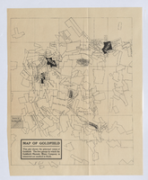
Map of Goldfield, circa 1904-1908
Date
1900 to 1912
Description
'This plat shows the principal mines of Goldfield. The five groups in which the Goldfield-Majestic Mines Company is interested are marked in black.'
Image