Search Results
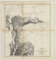
Maps of explorations and surveys for a railroad route from the Mississippi River to the Pacific Ocean, 1855
Date
1855
Description
Map no. 1. From the valley of Green River to the Great Salt Lake -- Map no. 2. From the Great Salt Lake to the Humboldt Mountains -- Map no. 3. From the Humboldt Mountains to the Mud Lakes -- Map no. 4. From the valley of the Mud Lakes to the Pacific Ocean. 'From explorations and surveys made under the direction of the Hon. Jefferson Davis, Secretary of War, by Capt. E.G. Beckwith, 3rd Artillery, E.G. Egloffstein, topographer for the route. 1855.' ''Selmar Siebert's Engraving & Printing Establishment, Washington, D.C.' Published by the War Dept. Scale 1:760,320. 12 miles to 1 in. Relief shown by hachures and spot heights.
Image
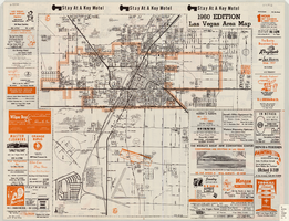
Las Vegas area map, 1960
Date
1960
Description
1960 ed. Scale [ca. 1:47,520. 1 in. equals approx. 0.75 miles.] 1 map : col. ; 41 x 43 cm., folded to 22 x 10 cm. Panel title: Welcome map : greater Las Vegas area and scenic routes to and from there. "1960-61 edition."--Panel. Irregularly-shaped map. Includes list of Las Vegas schools, inset maps of East Las Vegas (Whitney) and Wherry housing area on Nellis Air Force Base and advertisements for Las Vegas businesses. Index, mileages from cities in the United States to Las Vegas and sightseeing information on verso. Library's copy 1 has some art work and some lettering in orange and has "Las Vegas Nevada Chamber of Commerce" stamped in purple on panel. Library's copy 2 has some art work and some lettering in purple and has "Pioneer Title Insurance Co. of Nevada" stamped in black on panel. Nevada State Motel Association?
Text

Topographic map of Nevada-California, Las Vegas quadrangle, March 1908
Date
1908-03
Description
'Edition of Mar. 1908.' 'E.M. Douglas, geographer in charge; Topography and triangulation by R.H. Chapman, B.D. Stewart, J.E. Blackburn, and D.F.C. Moor. Surveyed in 1906-1907.' Scale 1:250,000 (W 116°00--W 115°00/N 37°00--N 36°00). Relief shown by contours and spot heights. Title in lower-right corner: Las Vegas. Contour interval 100 feet. Datum is mean sea level. "Topography"--Center of top margin. Text about the Topographic Maps of the United States series and symbols used on map on verso. U.S. Geological Survey
Text
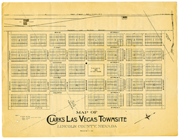
Map of Clark's Las Vegas Townsite, Lincoln County, Nevada, May 10, 1905
Date
1905-05-10
Archival Collection
Description
Scale: 1" = 100'. 1 map ; 28 x 22 cm. Verso of map is an announcement of the auction to be held May 15, 1905, for lots in the Las Vegas townsite. Pricing and lot information is included, as well as specials for railway tickets to Las Vegas from Los Angeles and Salt Like City. Las Vegas Land and Water Company
Text

Map of California, and territories of Utah, Nevada, Colorado, New Mexico and Arizona, 1864
Date
1864
Description
'Johnson's California, also Utah, Nevada, Colorado, New Mexico, and Arizona, published by A.J. Johnson, New York.' 'Entered according to act of Congress in the year 1864, by A.J. Johnson in the Clerks Office of the District Court of the United States for the southern district of New York.' Atlas page numbers in upper margin: 67-68. Relief shown by hachures. Prime meridian: Greenwich and Washington. Shows natural features, locations of Indian tribes, proposed railroad routes, routes of explorers, trails, county boundaries and populated places. Hand colored. On verso: 'Historical and statistical view of the West India Islands or Columbian Archipelago' (p. 80) and 'Historical and statistical view of Mexico and Central America' (p. 79). Scale [ca. 1:3,484,800]. 1 in. to ca. 55 miles (W 124°--W 102°/N 42°--N 32°).
Text
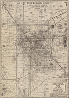
Road map of Hoover Dam and vicinity, circa 1949
Date
1947 to 1951
Description
'Cartography by W. C. Kainsinger, W.T. Taylor. Field mapping by K. R. Reed, G. Boyd. Typography by W. R. Williams.' 'Copyright by Automobile Club of Southern California. C-21351.' 'C-1352'--Panel. Index on verso. In lower right corner: 'Map number 1959.' Scale 1:415,210 (W 116°--W 114°/N 37°--N 35°). Relief shown by hachures and spot heights. Shows mines, ranches and springs. Not the same as the 1948 edition of this map. Cartographers', field mappers', typographers' names are different, and 2 out of 3 numbers on maps are different. Probably after 1947 as Boulder Dam has been changed to Hoover Dam, but before 1950 as Las Vegas Bombing and Gunnery Range has not been changed to Nellis Air Force Base. Automobile Club of Southern California.
Text
Map of desert area in southern Nevada and southeastern California, circa 1955
Date
1953 to 1957
Description
Covers the desert area in the Owens Valley, Death Valley, Las Vegas and Lake Mead region; bordered by Bishop and Inyokern, California, and Pioche and Lake Mead, Nevada. 'Cartography by W.T. Taylor, W.A. Neely. Color separation by H.P. Pflum; Relief by F.M. Burke; Typography by W.R. Williams. Field mapping by H.A. Cline, G.L. Boyd, K.R. Reed., W.A. Neely, R.P. Conklin.' 'Copyright by Automobile Club of Southern California.' Scale 1:483,537. 1 in. to approx. 8 miles (W 120°--W 114°/N 39°--N 33°). 'Map number 2217.'.
Text

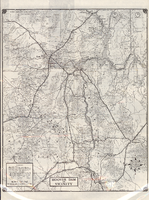
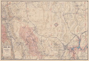
Map of Lincoln County, Nevada and Mohave County, Arizona area, 1892
Date
1892
Description
'Henry Gannett, chief geographer ; A.H. Thompson, geographer in charge ; triangulation by H.M. Wilson ; topography by H.M. Wilson and Powell survey.' 'Edition of Mar. 1892, reprinted 1929.' Handwritten legend on right-side margin of map. Original publisher: Dept. of the Interior, U.S. Geological Survey. Scale 1:250,000
polyconic proj. (W 115°--W 114°/N 37°--N 35°).
polyconic proj. (W 115°--W 114°/N 37°--N 35°).
Image
Map of Las Vegas Valley area, 1969
Date
1969
Description
'Featuring Las Vegas ... North Las Vegas ... Paradise Valley.' '1969 edition - revised' -- top of map. Original publisher: Front-Boy Service Co. 1969 ed. Scale [ca. 1:79,200]. 'Copyright - Russell A. Meador, 1968.' Front panel title: 'Front Boy's official 1969 edition street map.' Indexes on map verso. 'Walt Choik, editor, Front Boy Maps' -- back panel.
Text
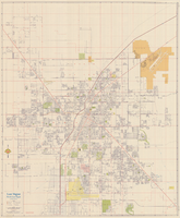
Map of Las Vegas, North Las Vegas, and vicinity, June 1975
Date
1975-06
Description
'Cartographic Department. Copyright by California State Automobile Association. C6-75.' 'Issued by California State Automobile Association and Automobile Club of Southern California. 6-75' on front panel. Indexes on map verso. Scale [ca. 1:32,400. 1 in. to approx. 2700 ft.]. California State Automobile Association.
Text