Search Results


Las Vegas SW quadrangle
Date
Description
'Prepared by the U.S. Department of the Interior, Geological Survey, in cooperation with the U.S. Department of Housing and Urban Development, Federal Insurance Administration. 1973.'
Image
Troutman, Porter
Alternate Names
Porter Troutman was born and raised in Newellton, a small farming community in Louisiana. He went to school to Ruth Wood Elementary School and graduated from a high school in St. Joseph, Louisiana. He then attended Southern University from 1961 to 1965 and earned his Bachelor's Degree. His father held a multitude of jobs to support the family and was highly involved in the Civil Rights movement.
Person
Gaming management and operational control files, 1965 to 2009
Level of Description
Scope and Contents
Materials contain manuals, statistics, reports, publications, research files, pamphlets, and newspaper articles created and collected by Gary W. Royer as a Nevada Gaming Control Board auditing agent, gaming consultant, and researcher (1965-2009). The series is primarily comprised of research files about various gaming facilities, mainly in Nevada, that include management and operational control procedure manuals, reports, and statistics. Also included are files about Native American gaming that include management and operational control procedure manuals, reports, and gaming compacts. The series also contains publications and reports created by Royer’s company, Casino Control Corporation (CCC). The series also includes manuals and reports about various aspects of casino management and operational control including accounting, auditing, lottery, automatic data processing, keno, and slots.
Archival Collection
Collection Name: Gary W. Royer Collection on Gaming
Box/Folder: N/A
Archival Component
UNLV Songleader Uniform
Identifier
Abstract
The UNLV Songleader Uniform (approximately 1975-1979) consists of one white, red, and blue uniform dress and jacket worn by a UNLV Songleader in the late 1970s.
Archival Collection
Gay Fiction Book Collection
Identifier
Abstract
The Gay Fiction Book Collection (1951-1976) is a small collection of fiction books published from the 1950s, 1960s, and 1970s that have gay men as the lead characters or storylines that relate to the gay community. The majority of the books were published in San Francisco, California and were collected and donated by Dennis McBride.
Archival Collection
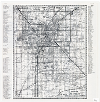
Map of greater Las Vegas area, 1964-1965
Date
Description
Text
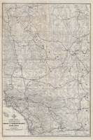
Map of a portion of southern California and southwestern Nevada, circa early 1930s
Date
Description
Text
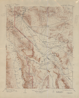
Topographic map of the Furnace Creek quadrangle, Nevada and California, 1947
Date
Description
'E.M. Douglas, geographer. R.H. Chapman, in charge of section. Topography by R.H. Chapman, B.D. Stewart, J.E. Blackburn and D.F.C. Moor. Traingulation by R.H. Chapman and D.F.C. Moor. Surveyed in1905-1906.' 'Edition of Apr. 1910, reprinted 1947.' Scale 1:250,000 ; polyconic proj. (W 117°00´--W 116°00´/N 37°00´--N 36°00´). Relief shown by contours and spot heights. 'North American datum.' 'Contour interval 100 feet.' 'Datum is mean sea level.' Text and illustrations from the Topographic maps of the United States series on verso. Series: The topograhic maps of the United States. United States, Dept. of the Interior, Geological Survey
Text
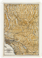
Map of a portion of southern California and southwestern Nevada embracing the arid region of Mojave & Colorado Deserts including Death Valley, circa 1937
Date
Description
Image