Search Results
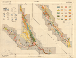
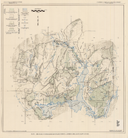
Soil map, Nevada, Moapa Valley sheet, 1923
Date
1923
Archival Collection
Description
'U.S. Department of Agriculture, Bureau of Chemistry and Soils; C.A. Browne, Acting Chief; Curtis F. Marbut, in charge, Soil Survey.' 'Macy H. Lapham, Inspector, District 5. Soils surveyed by F.O. Youngs, in charge, and E.J. Carpenter.' 'Field Operations, Bureau of Soils, 1923.' 'A, Hoen & Co. Lith. Baltimore, Md.' Shows township and range lines. Scale [1:63,360]. 1 in. = 1 mile (W 114°45´--W 114°18´/N 36°51´--N 36°24´). Library's copy has hand-written notes and has hand-drawn maps and notes on verso.
Image
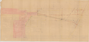
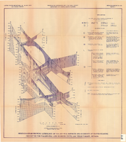
Map of Las Vegas Valley Water District, December 29, 1952
Date
1952-12-29
Archival Collection
Description
'Exhibit A.' 'Dec. 29, 1952.' 'I-128.' Scale [ca. 1:3,600]. 1 in.=300 feet. Shows water pipelines, other parts of the water system, and power lines to be removed or relocated when land is sold to the Las Vegas Valley Water District. Shows land to be sold and lists power requirements for water system. Includes township and range lines. Library's copy includes hand-written notations and calculations. Los Angeles & Salt Lake Railroad Company, Office of Vice President?
Image

Geologic map of Las Vegas Valley, Nevada, 1982
Date
1982
Description
At top of map:'Department of the Interior, U.S. Geological Survey. Prepared in cooperation with the Clark County Department of Comprehensive Planning. Water supply paper 2320-A, plate 1.' At bottom of map: ' Base from U.S. Geological Survey, 1:100,000, Boulder City, Ariz.-Nev., Las Vegas, Nev.-Calif., Mesquite Lake, Nev.-Calif., 1978; Lake Mead, Nev.-Ariz., 1979. Geology from Malmberg (1965); Longwell and others (1965); Haynes (1967); Bingler (1977); Bell and Smith (1980); Bell (1981); Matti and Bachhuber (1982); and Matti and Morton (1982a, b); modified by R. W. Plume, 1981.' Shows township and range lines. Scale 1:100,000 (W 115°30´--W 115°00´/N 36°30´--N 36°00´). Series: U.S. Geological Survey water-supply paper
2320-A. Originally published as plate 1 of Ground-water conditions in Las Vegas Valley, Clark County, Nevada. Part I. Hydrogeologic framework / by Russell W. Plume, published by the U.S. Geological Survey in 1989 as Water-supply paper 2320-A.
2320-A. Originally published as plate 1 of Ground-water conditions in Las Vegas Valley, Clark County, Nevada. Part I. Hydrogeologic framework / by Russell W. Plume, published by the U.S. Geological Survey in 1989 as Water-supply paper 2320-A.
Image
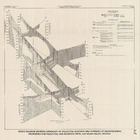
Fence diagram showing lithology of valley-fill deposits and summary of water-bearing properties for valley-fill and bedrock units, Las Vegas Valley, Nevada, 1981 (Water-supply paper 2320-A)
Date
1981
Description
'Department of the Interior, U.S. Geological Survey. Water-supply paper 2320-A, plate 2.' 'Prepared in cooperation with the Clark County Department of Comprehensive Planning.' 'Geology by R.W. Plume, 1981.' Scale [ca. 1:95,040. 1 in.=approx. 1.5 miles]. Series: U.S. Geological Survey water-supply paper
2320-A. Originally published as plate 2 of Ground-water conditions in Las Vegas Valley, Clark County, Nevada. Part I. Hydrogeologic framework / by Russell W. Plume, published by the U.S. Geological Survey in 1989 as Water-supply paper 2320-A. "Prepared in cooperation with the Clark County Department of Comprehensive Planning."
2320-A. Originally published as plate 2 of Ground-water conditions in Las Vegas Valley, Clark County, Nevada. Part I. Hydrogeologic framework / by Russell W. Plume, published by the U.S. Geological Survey in 1989 as Water-supply paper 2320-A. "Prepared in cooperation with the Clark County Department of Comprehensive Planning."
Text
Index map showing locations of geologic sections on plate 2 and wells on plates 2 and 3, Las Vegas Valley, Nevada, 1981 (Water-supply paper 2320-A)
Date
1981
Description
'Department of the Interior, U.S. Geological Survey. Water-supply paper 2320-a, plate 4.' 'Prepared in cooperation with the Clark County Department of Comprehensive Planning.' 'Base from U.S. Geological Survey 1:100,000 , Boulder City, Ariz.-Nev., Las Vegas, Nev.-Calif., Mesquite Lake, Nev.-Calif., 1978, Lake Mead, Nev.-Ariz., 1979.' 'Geology from Malmberg (1965); Longwell and others (1965); Bell and Smith (1980); and J. R. Harrill, 1976.' Shows township and range lines. Scale 1:100,000 (W 115°30´--W 115°00´/N 36°30´--N 36°00´). Series: U.S. Geological Survey water-supply paper
2320-A. Originally published as plate 4 of Ground-water conditions in Las Vegas Valley, Clark County, Nevada. Part I. Hydrogeologic framework / by Russell W. Plume, published by the U.S. Geological Survey in 1989 as Water-supply paper 2320-A.
2320-A. Originally published as plate 4 of Ground-water conditions in Las Vegas Valley, Clark County, Nevada. Part I. Hydrogeologic framework / by Russell W. Plume, published by the U.S. Geological Survey in 1989 as Water-supply paper 2320-A.
Image

Map showing general geology and areas of artesian flow of the Las Vegas, Pahrump, and Indian Spring Valleys, Clark and Nye Counties, Nevada, 1946
Date
1947
Description
'United States Department of Interior, Geological Survey, Water Resources Bulletin No. 6.' 'State Engineer of Nevada.' Relief shown by contours. Includes township and range lines. Scale [ca. 1:126,720. 1 in.=approx. 2 miles]. Series: Water resources bulletin (Carson City, Nev.)
no. 6. Originally published as plate 1 in Ground water in Las Vegas, Pahrump, and Indian Spring Valleys, Nevada : a summary / G. B. Maxey and T. W. Robinson, prepared in cooperation with the United States Department of the Interior, Geological Survey, and published as no. 6 of the Water resources bulletin.
no. 6. Originally published as plate 1 in Ground water in Las Vegas, Pahrump, and Indian Spring Valleys, Nevada : a summary / G. B. Maxey and T. W. Robinson, prepared in cooperation with the United States Department of the Interior, Geological Survey, and published as no. 6 of the Water resources bulletin.
Image
Generalized hydrogeologic map of lower Moapa-Lake Mead area, Clark County, Nevada, 1968
Date
1968
Description
'Hydrogeology by F.E. Rush, 1968. Geology adapted from Longwell and others 1965.' In lower left corner: ' Base: U.S. Geological Survey 1:250,000 topographic series; Las Vegas (1954).' At top of map: 'United States Department of the Interior, Geological Survey. Department of Conservation and Natural Resources, State of Nevada.' Relief shown by contoursIncludes township and range lines. Scale 1:250,000 (W 115°00´--W 114°15´/N 36°30´--N 36°15´). Series: Water resources-reconnaissance series report . Originally published as plate 1 in Water-resources appraisal of the lower Moapa-Lake Mead area, Clark County, Nevada / by F. Eugene Rush, published by State of Nevada Dept. of Conservation and Natural Resources in 1968 in volume 50 of the serial Water resources-reconnaissance series report.
Image

Surficial geologic map of Las Vegas Valley, Nevada, circa 1981
Date
1977 to 1985
Description
'United States Department of the Interior, Geological Survey. Open-file report, 84-130, plate 1.' 'Prepared in cooperation with the Clark County Department of Comprehensive Planning.' 'Base from U.S. Geological Survey 1:100,000, Boulder City, Ariz.-Nev., Las Vegas, Nev.-Calif., Mesquite Lake, Nev.-Calif., 1978, Lake Mead, Nev.-Ariz., 1979.'Geology from Malmberg (1965); Longwell and others (1965); Haynes (1967); Bingler (1977); Bell and Smith (1980); Bell (1981); Matti and Bachhuber (1982); and Matti and Morton (1982a and b); modified by R. W. Plume, 1981.' Shows township and range lines. Scale [ca. 1:102,960. 1 in.=approx. 1.625 miles] (W 115°30´--W 115°00´/N 36°30´--N 36°00´). Series: Open-file report (Geological Survey (U.S.))
84-130. Originally published as plate 1 of Ground-water conditions in Las Vegas Valley, Clark County, Nevada. Part I. Hydrogeologic framework / by Russell W. Plume, published by the U.S. Geological Survey in 1984 as Open-file report 84-130.
84-130. Originally published as plate 1 of Ground-water conditions in Las Vegas Valley, Clark County, Nevada. Part I. Hydrogeologic framework / by Russell W. Plume, published by the U.S. Geological Survey in 1984 as Open-file report 84-130.
Image
Fence diagram showing lithology of valley-fill deposits and summary of water-bearing properties for valley-fill and bedrock units, Las Vegas Valley, Nevada, 1981 (Open-file report 84-130)
Date
1981
Description
'United States Department of the Interior, Geological Survey. Open-file report 84-130, plate 2.' 'Prepared in cooperation with the Clark County Department of Comprehensive Planning.' 'Geology by R.W. Plume, 1981.' Scale [ca. 1:31,680. 1 in.=approx. .5 miles]. . Series: Open-file report (Geological Survey (U.S.))
84-130. Originally published as plate 2 of Ground-water conditions in Las Vegas .Valley, Clark County, Nevada. Part I. Hydrogeologic framework / by Russell W. Plume, published by the U.S. Geological Survey in 1984 as Open-file report 84-130. "Prepared in cooperation with the Clark County Department of Comprehensive Planning."
84-130. Originally published as plate 2 of Ground-water conditions in Las Vegas .Valley, Clark County, Nevada. Part I. Hydrogeologic framework / by Russell W. Plume, published by the U.S. Geological Survey in 1984 as Open-file report 84-130. "Prepared in cooperation with the Clark County Department of Comprehensive Planning."
Text
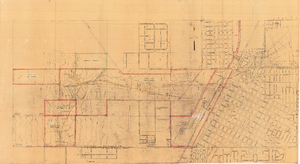
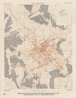
Map of Las Vegas showing areas owned by the Union Pacific Railroad Company, water pipes and other water utilities, circa 1942
Date
1938 to 1946
Archival Collection
Description
Map showing downtown Las Vegas and tracts to the west showing water supply lines, wells, springs, and settling basins. Various areas outlined in red and yellow. Scale [ca. 1:7,200] 1 in.=600 feet. Cadastral map. Blueline print. Areas owned by railroad outlined by hand in different colored markers. Library's copy includes hand-written calculations.
Image